 Faults of the Bohemian Massif
Source of Analytical Data on Main Faults and Faulted Areas with Seismic Potential
User Tools
Sidebar
Table of Contents
Rodl-Blanice Fault System (RBFS)
Structure ID:
Fault Section IDs:
Related terms:
Editor: Ivan Prachař
Last update: 6. 12. 2022
Blanice Furrow Faults
Drahotěšice Fault
Rudolfov Fault
Kaplice Fault
Rodl Fault
http://resource.geolba.ac.at/structure/182 | Kourim-Blanice-Kaplice-Rodl-Großstörungssystem nach Geologische Bundesanstalt /AT/
General description
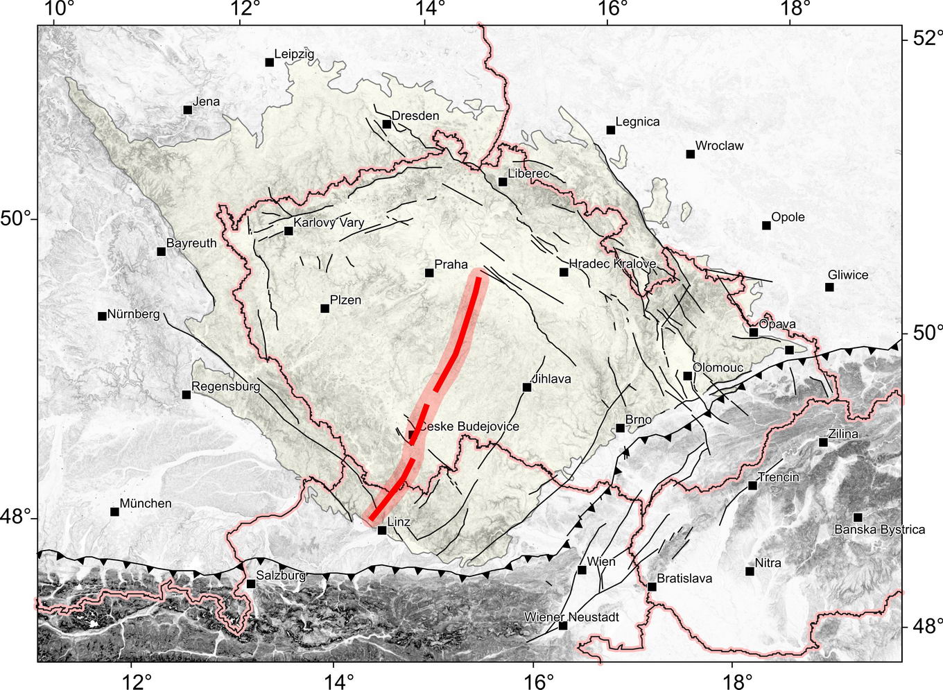
Kourim-Blanice-Rodl-Kaplice Large-scale Fault System is ca. 250 km long, approximately NNE-SSW trending large-scale fault system which extends from the Kouřim Furrow in the North, following the Blanice Furrow, crossing the basins of Třeboň and České Budějovice via Kaplice (CZ) and the valley of the Große Rodl to Gramastetten (A) and the basin of Eferding, where it is partly covered by Miocene sediments, but continues into the basin subsurface (see http://resource.geolba.ac.at/structure/182).
This large-scale fault system is divided into several partial faults or fault systems, which are from north to south: Blanice furrow faults, Drahotěšice fault, Rudolfov fault, Kaplice fault and Rodl fault. Although these faults belong to one large-scale system with many common features, each of them has its own specifics and should therefore be described separately. However, this large-scale system can be divided into two major parts, especially in terms of the occurrence of relics of Permo-carboniferous sediments. The Blanice furrow faults are related to these relicts, and it is necessary to associate these faults with the Drahotěšice fault and Rudolfov fault. The second group consists of Kaplice fault and Rodl fault, whose point of connection is determined essentially by the usage.
Blanice Furrow Faults
The Permo-Carboniferous of the Blanice furrow forms a discontinuous, up to 12 km wide strip of deposits, running in the direction of NNE-SSW from Český Brod to České Budějovice. In the north, around Český Brod, Kouřim and Kostelec nad Černými Lesy (northern part of the furrow), and in the south, between České Budějovice and Lhotice (southern part), these occurrences have the largest area. The middle part includes several smaller occurrences around Vlašim and Tábor (see Fig. 1). According to the fossil flora, the lower series present in the furrow is considered the Stephanian C in terms of age, while the deposits that follow above are assigned to the Autunian. The transition of the Upper Carboniferous sediments to the Lower Permian is continuous (see PEŠEK ET AL., 2001). See also Raster geological maps 1 : 50 000, Czech Geological Survey - sheet 22-44 Hluboká, 23-31 Soběslav, 23-13 Tábor, 23-11 Vlašim, 13-33 Benešov, 13-31 Říčany.
Fig. 1: Sketch of the course of the Blanice Furrow between Český Brod and České Budějovice. Adopted from PEŠEK (2001).
The Drahotěšice fault and parallel Lhotice fault, as well as the eastern marginal fault of the Lhotice Basin (so far referred to as RUD?_04), also belong to the faults of the Blanice furrow. The course of the Drahotěšice fault is best evident on its 20 km long section between Dolní Bukovsko in the north and Úsilné in the south (sections DRA_02 to DRA_05). However, it can be expected continuation of the fault to the north and south.
On a short, about 1.7 km long section near Úsilné, the Drahotěšice fault is the western limitation of the Permian Lhotice basin in the west according to the Raster geological map 1 : 50 000, Czech Geological Survey - sheet 32-22 České Budějovice. But this assumption contradicts the findings from the drill US-2 (see LÁNA, 1973). At a depth of 70.6 - 92.2 m, a layer of Permian-Carboniferous arkoses to arkose conglomerates of mostly light gray and gray-green color was found, up to “white-gray arkose boulder conglomerate” (91.6 - 92.2 m) on the base. Furthermore, weathered, migmatitized paragneiss were drilled up to 127.7 m, where the drilling was terminated. These sediments most likely belong to the basal Peklov layers (Stephanian C) – see PEŠEK ET AL. (2001). Therefore, it is not certain that the geological map 1 : 50 000 - sheet 32-22 České Budějovice shows the real marginal fault of the Lhotice Basin near Úsilné.
Further to the north, between Borek in the south and Baba hill in the north, the Drahotěšice fault is accompanied by an intrusion of Ševětín granodiorite. Limitation to Permian sediments here takes over the parallel Lhotice fault tending to NNE between Borek and Lhotice (see Raster geological map 1 : 50 000, Czech Geological Survey - sheet 22-44 Hluboká). Between Drahotěšice in the south and Dolní Bukovsko in the north, the fault limits a block of sediments of the Klikov Formation of the Třeboň Basin (more about the Klikov Formation see e.g. SLÁNSKÁ, 1974 and SLÁNSKÁ, 1976), situated to the east of the fault, with an offset documented by drills around 110 - 125 m (see Raster geological map 1 : 50 000, Czech Geological Survey - sheet 22-44 Hluboká).
In the section north of the Dolní Bukovsko, Drahotěšice fault becomes more difficult to track, but the presence of a fault is assumed (see KADLECOVÁ AND BURDA ET AL., 2016). In the surroundings of Dolní Bukovsko, sediments of the Klikov Formation extend across the fault line to the west, but in a very small thickness. E.g. the thickness of the Cretaceous sediments was only 15 m in the drill V-19 (see ZÍMA, 1961). In contrast, Cretaceous sediments with a thickness of 115 m were found in the eastern side of the fault (see drill V-18. ZÍMA, 1961). Behind the Třeboň Basin towards the north, the fault is no longer visible (see Raster geological map 1 : 50 000, Czech Geological Survey - sheet 22-42 Bechyně).
The course of the Rudolfov fault is characterized by the fact that it forms the eastern edge of the Budějovická Basin (see the Raster geological map 1 : 50 000, Czech Geological Survey - sheet 32-22 České Budějovice). In geological maps this fault is plotted along the surface boundary of the basin. According to the assumption of PRACHAŘ (2012) this applies only partially, at the southern part of the fault between the villages of Roudné and Plav. In the north, the fault is not curved, as shown by geological maps, but runs straight in the direction of NNE-SW, inside the basin.
According to interpretation of PRACHAŘ (2012), the crossing of Blanice faults system and fault zone of the Hluboká fault is separated into many blocks and tectonic slices with various level of the sedimentary formation basements. This complicated structure is a result of inverse movements on both faults system, some of them have character of the ramps - up thrusts with steep dip of the thrust plane.
When these tectonic blocks are mapped, it is very useful to monitor the positions of the Permo-Carboniferous blocks. Geological maps show the stepped displacement of blocks and slices of Permo-carboniferous towards the east when i tis observed from north to south. In the area of Červený vrch it is possible to observe the surface occurrence of Permo-carboniferous, which is limited by fsection RUD?_03 in the east. As the occurrence of Permo-carboniferous located under Cretaceous sediments was proven in the vicinity of the village of Nové Vráto (see drill NVr-1 /MALECHA, 1994/ and shaft »Jáma II«, which mined anthracite /see Geofond register of mines), it is possible, by analogy to northern block, to limit this block by faults in both west and east. We assume that this role has fsection RUD_02 in the east. The western limit of this block must be given by some fsection of the Drahotěšice fault (DRA_01 or DRA_01P). Furthermore, we assume that the edge of Cretaceous sedimentation has a transgressive character, and thus that fsection RUD_02P does not represent a fault.
Further to the south, between the villages of Roudné and Plav, the trace of the Rudolfov fault coincides with the edge of the basin.
Kaplice-Rodl Fault
The course of the Kaplice fault zone is characterized by a series of parallel fault lines, generally following the direction of NNE-SSW (see the Raster geological map 1 : 50 000, Czech Geological Survey - sheet 32-22 České Budějovice and 32-24 Trhové Sviny). It can be described as a shear zone. According to geological maps mentioned above, some faults separate the block of the Moldanubian metamorphites from different types of the granitic rocks of the Central Moldanubian Pluton.
There is no clear separation between the Rodl fault and Kaplice fault, but there is a custom that the fault is known as Rodl on Austrian territory and as Kaplice on Czech one. The Czech part - the Kaplice fault runs from Dolní Dvořiště in the south, along the town of Kaplice to Dolní Stropnice in the north (Fsections KPL_01 to KPL_03). In addition, the parallel section KPL_04P has been defined, which runs from Netřebice in the south to Straňany in the north, about 1.5 to 2 km west from KPL_03.
As Rodl fault s.s. is considered ca. 55 km long, approximately NNE-SSW trending fault system, which extends from Rybník (CZE), following the valley of the Große Rodl to Gramastetten and the basin of Eferding, where it is partly covered by Miocene sediments, but continues in the basin subsurface (see http://resource.geolba.ac.at/structure/185).
Rodl fault system includes partly parallel trending shear zones and faults, as e.g. Haselgraben subfault system. This ca. 15 km long N-S trending subfault system extends from Hellmondsödt, following the Haselgraben valley to Linz. It is part of the Rodl-Kaplice fault system and includes ductile parallel trending shear zones with left-lateral kinematics active during the Late Variscian (see http://resource.geolba.ac.at/structure/184).
Fault structure and dip
Blanice Furrow Faults
The faults of the Blanice furrow are described as western (marginal) faults (BF_xxW) and eastern (marginal) faults (BF_xxE). It is assumed that these faults are vertical or steep in dip, as the Drahotěšice fault. The dip is assumed steep to the east (western faults) or west (eastern faults). Information on the fault core, except for Drahotěšice fault, is not available, yet.
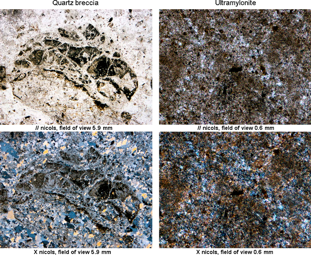
The dip of the Drahotěšice fault plane is assumed to be very steep with direction generally to the east, but opposite dip (to the west) is not excluded, as can be deduced from the log of the ŠV-2 drill (for detail see Fevidence DRA_A). In the surroundings of Drahotěšice the course of the fault is highlighted by a quartz vein (tectonic breccia – see Fig. 1). On the western edge of the Lhotice basin, between Borek and Lhotice, two parallel fault planes are running. Among them, the Ševětín granodiorite is pulled up into a thin, only about 150 m thick tectonic slice. The Lhotice fault separating granodiorite and Permian sediments is filled with a few meters thick grayish-black ultramylonite (see Fig. 2).
Fig. 2: Thin section of quartz breccia from the quartz vein outcrop near Drahotěšice (left). Thin section of ultramylonite from the fault core outcrop near Chyňava (right). Photo I. Prachař.
The dip of the Rudolfov fault plane is assumed to be very steep with direction generally to the west.  . More detailed data aren’t available.
Kaplice-Rodl Fault
The dip of the Kaplice fault plane is assumed to be very steep with direction generally to the west.  . More detailed data aren’t available.
The core of the Rodl fault is formed by mylonites to phyllonites. The mother rocks from which the mylonitic rocks originated are pearl gneisses, migmatites and Weinsberger-type granite (see IGLSEDER, 2013; WALLBRECHER ET AL., 1993). Depending on the direction and dip of the mylonite foliation, it can be concluded that the fault has a steep dip (about 80°) to NW. Mylonites have lineation in the direction of NE-SW (see WALLBRECHER ET AL., 1993).
Cross structures and Segmentation
Blanice Furrow Faults
Geological maps (see e.g. Raster geological maps 1 : 50 000 of Czech Geological Survey) show a series of transverse faults that either limit the occurrence of Permo-Carboniferous in the south or north, or divide the basins into blocks of varying depth. Two important cross structures that limits the occurrence of Permian sediments near České Budějovice show also Raster geological map 1 : 50 000, Czech Geological Survey – sheets 22-44 Hluboká and 32-22 České Budějovice in the zone of the Drahotěšice fault, incl. Lhotice fault.
In the south, Lhotice basin is limited by Hluboká fault towards filling of the Cretaceous Budějovice Basin. However, the drills show that the Permian sediments are spread even under the base of Cretaceous sediments, south of the Hluboká fault (see Fsection DRA_01). Northern limitation of the Lhotice Basin forms the Dobřejovice fault of the WNW-ESE direction. According to the geological map (see e.g. Raster geological map 1 : 50 000, Czech Geological Survey – sheets 22-44 Hluboká), Dobřejovice fault interrupts the line of the Drahotěšice fault near Chotýčany.
Leaving aside unconfirmed transverse faults breaking the eastern edge of the Budějovická Basin, the Rudolfov fault runs intact along the eastern edge of the basin from Vráto in the north to Straňany in the south. Segmentation of the fault, as shown by geological maps, was not confirmed, for example, by the work of PRACHAŘ (2012). To the north, if the eastern marginal fault of the Lhotice Basin is considered to be part of the Rudolfov fault, this fault is segmented by two branches of the Hluboká fault (HLU_07 and HLU_08) in the south and by a W-E fault running across the Lhotice Basin between Chýňová and Jelmo.
Kaplice-Rodl Fault
Geological map (see e.g. Raster geological map 1 : 50 000, Czech Geological Survey – sheet 32-24 Trhové Sviny) shows a series of transverse strike-slip faults that divide the Kaplice fault (Fsection KPL_02) into segments 2.5 to 4 km long. These segments limit the relics of the sediments of the Mydlovarský Formation near Kaplice. However, the limitation of these relics by faults with post-Miocene activity has not yet been proven. In the north, on the other hand, it is possible to define one uninterrupted section 12 km long (KPL_03) between Pořešinec and Dolní Stropnice. Similarly, the KPL_04 section appears as two 8.7 km and 4.1 km long uninterrupted sections.
On Raster geological map of Upper Austria 1 : 200 000 is not drawn any fault that would segmented the Rodl fault. But Pfahl shear zone and Danube fault are terminated by the Rodl fault.
Scarp morphology
Blanice Furrow Faults
The morphological manifestation of the Drahotěšice fault is not very pronounced. Nevertheless, it is possible to observe a slight lowering of the relief in the eastern side of the fault, in the Lhotice Basin (see Fig. 4).
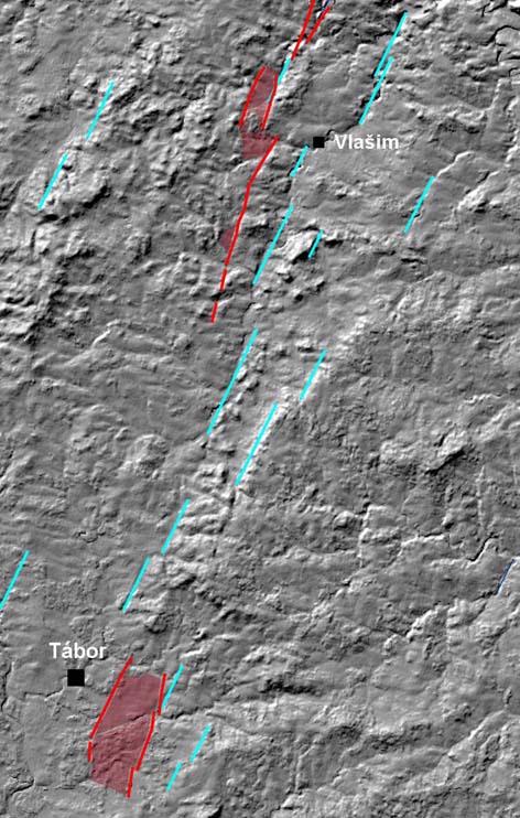
Between Tábor and Vlašim, in the Blanice furrow zone, it is possible to observe a number of topo-lineaments with an azimuth of 19° (NNE-SSW). However, these topo-lineaments do not positionally correlate with faults limiting Permo-Carboniferous occurrences (see Fig. 3). In the north, between Sázava and Kouřim, topo-lineaments and fault drawings correlate very well. The long topo-lineament (12 km) separates the higher and more broken relief in the west from the lower, smoothed relief in the east.
Fig. 3: Digital model of relief between Tábor and Vlašim with marked topo-lineaments (light blue), faults (red) and occurrences of Permo-Carboniferous (red brown).
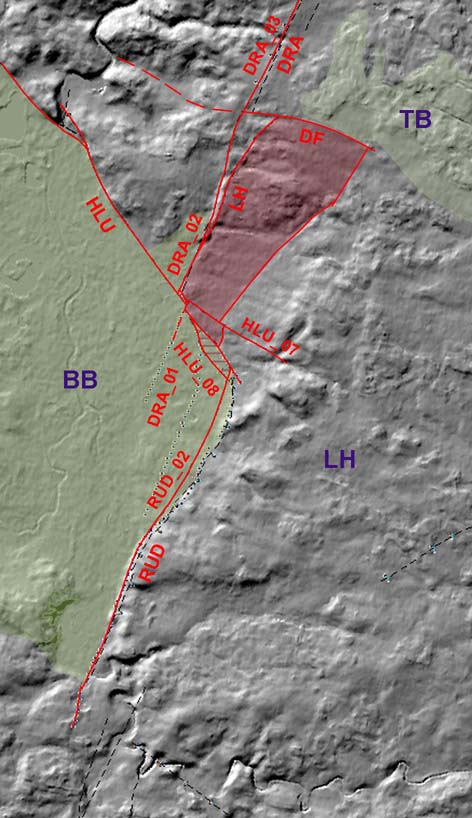
The eastern edge of the České Budějovice Basin is very distinctive in terms of morphology (See Fig. 4).
Fig. 4: Significant morphological slope on the eastern edge of the České Budějovice Basin with marked major faults and their Fsections: HLU – Hluboká fault; DRA – Drahotěšice fault; RUD – Rudolfov fault; LH – Lhotice fault; DF - Dobřejovice fault. Geological units: TB – Třeboň Basin, BB - Budějovice Basin; LH – Lišov horst. Green colour – Cretaceous basins; Red-brown – Permo-carboniferous; Green with red-brown lines – Permo-carboniferous covered by Cretaceous.
Kaplice-Rodl Fault
Kaplice fault: It has not been monitored yet. 
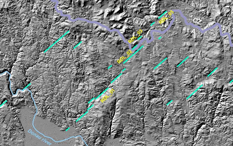
The course of the Rodl fault is particularly pronounced between Gramastetten (A) in the south and Unterstiftung (A) in the north, where the course of the fault coincides with the Große Rodl valley. Fig. 5 shows a group of converged topo-lineaments with azimuth 41° (NE-SW) in section RDL_01. Towards the northeast, it is possible to observe several parallel topo-lineaments following the course of the fault sections of the NE-SW direction. These sections are interconnected by sections of the fault, where the fault run in a direction rather NNE-SSW.
Fig. 5: Topo-lineaments related to the Rodl fault zone.
Seismicity
Blanice Furrow Faults
No earthquake epicenters were recorded in the Blanice Furrow fault zone. Except for two micro-earthquake, first near Planá nad Lužnicí (49.355°N, 14.762°E on August 21, 2005, which had ML = 0.1 and second near Veselí na Lužnicí (49.207°N, 14.606°E on October 24, 2005, which had ML = 0.
Kaplice-Rodl Fault
No earthquake epicenters were recorded in the Kaplice fault zone. In case of the Rodl fault it will be revisited after completion of earthquake catalogue. 
Pre-Miocene evolution
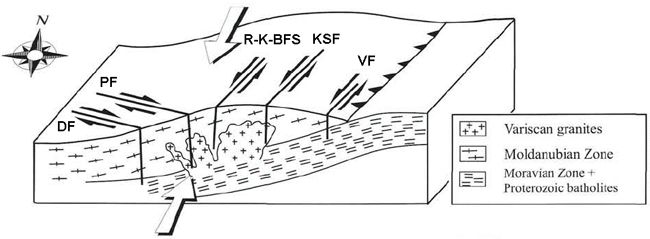
The beginning of Kourim-Blanice-Rodl-Kaplice shear zone formation is dated to the Early Paleozoic in connection with the formation of the Moldanubian nappes as a result of large-scale northeastward directed transpression of an Early Paleozoic terrane. After this main tectonic event, shear activity initiated on the dextral shear zone set of the Pfahl and Danube Shear Zones and in the sinistral Kaplice-Rodl, Karlstift and Vitis Shear Zones (see BRANDMAYR ET AL., 1997), as shown in Fig. 6. However, the main ductile deformation phase is dated to the Late Variscian, showing mainly right-lateral movement (see http://resource.geolba.ac.at/structure/185). A long-lasting and multiphase deformation history can be assumed at these zone, among other during the Permian and Cretaceous Era. Proofs of NE-SW-trending left-lateral strike-slip ductile mylonitic shear zones during Upper Carboniferous and Permian times on the Kaplice-Rodl fault were presented by BRANDMAYR, ET AL.(1995); BÜTTNER (2007) or IGLSEDER (2013).
Fig. 6: Initial shear zone activity in the Danube (DF), Pfahl (PF), Rodl-Blanice (R-K-BFS), Karlstift (KSF) and Vitis (VF) Shear Zones. Arrows indicate major compression directions. Adopted from BRANDMAYR ET AL. (1997).
Blanice Furrow Faults
The asymmetric structure of the Blanice furrow originated on a pre-sedimentary-developed system of faults that were oriented in the NNE-SSW direction, and which was revived during the intra-Stephanian phase of Variscan orogenesis. Either primary depression or tectonically predisposed ditches were created. The subsidence axis was usually located at the eastern edge of accommodation space. Permo-Carboniferous occurrences are mostly tectonically limited on both sides, but occurrence around Český Brod, Kouřim and Kostelec nad Černými Lesy is limited only in the east. In addition to the NNE-SSW faults, which in some cases also turn to the NNW-SSE direction, E-W and NW-SE faults were also created, which allowed occurrence of transverse depressions. Faults acted as normal faults as well as oblique faults. Both the intensive syn-sedimentary and post-sedimentary subsidence occurred in the Blanice furrow (see PEŠEK ET AL., 2001).
The sediments in Blanice furrow are usually inclined to the east under an angle of 10° - 40°. The furrow filling is built by two formations – Kostelec and Český Brod. The oldest layers of the sequence are the Peklov layers, which were deposited during Stephanian C. The age of the lower Autunian was determined for the Lhotice layers. The younger Český Brod Formation consists of the Chýnov layers (the upper part of the lower Autunian) and the “Bulánské” layers (the beginning of the upper Autunian) - see PEŠEK ET AL. (2001).
In case of the Drahotěšice fault there are observations that the fault was reactivated many times, and inverse movements of the individual blocks of the fault occurred. According to MALECHA (1994) and VRÁNA ET AL. (1994), the dip-slip movements alternated with the reverse-slip movements, and the dip of the fault plane also changed in terms of angle and direction. Drahotěšice fault, as well as Rudolfov fault played a very important role during opening and development of the Permian and Cretaceous basins. Paleogene movements are also likely, but convincing observations are not available, yet.
Fault activity in late Cenozoic
Tertiary
According to IGLSEDER (2013) the deformation on the Kaplice-Rodl fault continuous with left-lateral strike-slip faulting during Cretaceous and Miocene times, indicated by sediment deposits. IGLSEDER (2013) suggests displacement up to 35 km (see also http://resource.geolba.ac.at/structure/183). Geological map (see e.g. Raster geological maps 1 : 50 000 of Czech Geological Survey, sheet 23-13 Tábor) indicates that tertiary (Miocene) sediments are faulted by Blanice furrow faults, too. However, such Miocene activity of these faults has not been proven. Miocene activity of the Drahotěšice fault was also assumed by A. Malecha (SEE MALECHA, 1994). Later surveys, however, did not confirm the Malecha’s concept of Miocene tectonic ditches, as e.g. nearby Pořežany ditch (see PRACHAŘ, 2012). Post Miocene activity of the whole Kouřim-Blanice-Kaplice-Rodl fault system has not been proven.
Quaternary
There is no evidence that this fault system was active in the Quaternary.
Related local evidence
(See layer Local evidence on a map. The sites are listed in south-to-north order.)
Local evidence was processed only for Drahotěšice fault.
Drahotěšice: Deep drill ŠV-2
evi_ID: DRA_A
fsec_IDs: DRA_04
editor: Ivan Prachař
The nature of the fault zone can be inferred from the log of the deep drill ŠV-2 (see MALECHA, 1994) excavated by Czech geological survey northeast of Drahotěšice in 1986. The borehole was placed in close proximity to the quartz vein, to the western side of the fault. The silicified tectonic breccia was passed by drill from 6 m up to 128.4 m, then, until the final depth of 259 m, a dark gray to black clay breccia with fragments of vein quartz was drilled. At a depth of 190.2-194.0 m, the breccia was light gray and contained a vein of pink carbonate. A similar fragment of breccia was found at a depth of 225.6 m. The fragments contained slightly clayey sandstone to conglomerates surrounded by tectonic breccia. The author (A. Malecha) assigned it to the Klikov Formation (Upper Cretaceous) and considers it to be evidence of inverse movements at the Drahotěšice fault in the post Cretaceous period.
Úsilné: Trench for waterpipe
evi_ID: USI_D
fsec_IDs: DRA_02
editor: Ivan Prachař
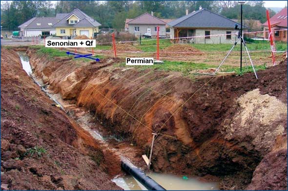
The contact between the Permian and Cretaceous sediments was investigated in the R-V trench for waterpipe about 700 m long on the southern edge of Úsilné (see Fig. 7), approximately at the point where the Drahotěšice fault is drawn on the geological maps.
Fig. 7: View of the western end of the water pipe excavation south of the village of Úsilné. The contact between the Senonian sediments of the Budějovice Basin and the Permian sediments of the Lhotice Basin was uncovered by the trench. Senonian sediments and contact are covered by a layer of fluvial sands and slope sediments affected by gelifluction. Photo I. Prachař, 2009.
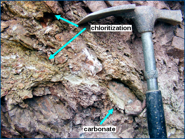
Permian sediments were affected by faulting, as shown the upturned beds of siltstones and claystones in the profile. The direction of bedding was in the range of 10° - 20° (NNE-SSW). The same direction had tectonic dislocations, generally also towards the NNE-SSW. The dip of the fault planes was very steep, both towards the ESE and WNW. Permian rocks were considerably cracked to crushed, with a few slickensides, oblique striations and occasionally with signs of chloritization (see Fig. 3 and Fig. 4). Towards the east, the frequency of faults decreased (see PRACHAŘ ET AL., 2012 and PRACHAŘ, 2012).
However, the contact zone was covered by Quaternary fluvial sands and partly also by slope sediments, so it was not possible to determine unambiguously the character of the contact between these units. As drilling in the surrounding area has shown, transgression of Senonian sediments over Permian is very likely. This is assumed only in the embayment of Budějovice Basin near Borek, where the Cretaceous sediments cross the line of the Hluboká fault towards the north.
Fig. 8: Detail view of the wall of the R-V trench with exposed Permian siltstones with slickensides and oblique striations on the divisional planes. Photo I. Prachař, 2009.
Fig. 9: Tectonically affected and altered Permian siltstones dusters in the zone of Drahotěšice fault with carbonate veins and crushed zones with chlorite. Úsilné, R-V trench. Photo I. Prachař, 2009.
Main data sources for fault map
See text above.
Other notes
…
References
- BRANDMAYR, M., LOIZENBAUER, J. & WALLBRECHER, E., 1997. Contrasting P-T conditions during conjugate shear zone development in the Southern Bohemian Massif, Austria.- Mitteilungen der Österreichischen Geologischen Gesellschaft 90, p. 11-29.
- BÜTTNER, S.H., 2007. Late Variscan stress-field rotation initiating escape tectonics in the south-western Bohemian Massif: A far field response to late-orogenic extension.- In: Journal of Geosciences 52, Nr. 1-2, S. 29-43.
- IGLSEDER, C., 2013. Bericht 2011-2012 über geologische Aufnahmen im Kristallin der Böhmischen Masse auf Blatt 4319 Linz. - Jahrbuch der Geologischen Bundesanstalt 153, 1-4, 434-438. [in German]
- KADLECOVÁ, R., BURDA, J., ET AL., 2016. Rebilance zásob podzemních vod. Příloha č. 2/14 – Stanovení zásob podzemních vod. hydrogeologický rajon 2151 – Třeboňská pánev – severní část. Final report, Česká geologická služba, 2016. [in Czech]
- LÁNA, V., 1973. Průzkumný hydrogeologický vrt US-2 Úsilné. Manuscript, Vodní zdroje, Praha. Geofond archive, sign. GF V070291. [in Czech]
- MALECHA A. (1994): Geologická a tektonická stavba jihovýchodní části budějovické pánve a její vývoj. Unpublished manuscript
 . Dolní Bukovsko, 1994, 27 pp. [in Czech]
 - PEŠEK, J. ET AL., 2001. Geologie a ložiska svrchnopaleozoických limnických pánví České republiky. Český geologický ústav, 243 p., Praha, 2001. [in Czech]
- PRACHAŘ, I., 2012. Lokalita JE Temelín. Komplexní charakteristika lokality z hlediska splnění geologických a seismologických požadavků na lokalitu jaderného zařízení. Unpublished manuscript
 , RNDr. Ivan Prachař, CSc. Praha. 2012. [in Czech]
 - SLÁNSKÁ, J. 1974. Continental Cretaceous and Tertiary Sedimentation in the South Bohemian Basin. Neues Jahrbuch für Geologie und Paläontologie, Abhandlung 146(3), 385–406.
- SLÁNSKÁ, J. 1976. A red-bed formation in the South Bohemia Basin, Czechoslovakia. Sedimentary Geology 15(2), 135–164. DOI 10.1016/0037-0738(76)90041-5
- WALLBRECHER, E., BRANDMAYR, M., HANDLER, R., LOIZENBAUER, J., MADERBACHER F., PLATZER, R., 1993. Konjugierte Scherzonen in der südlichen Böhmischen Masse: Variszische und Alpidische kinematischen Entwicklungen. Mitt. Österr. Miner. Ges. 138 (1993), 237-252. [in German]
- http://resource.geolba.ac.at/structure/182 (state to 2020-03-02).
- http://resource.geolba.ac.at/structure/183 (state to 2020-03-02).
- http://resource.geolba.ac.at/structure/184 (state to 2020-03-02).
- http://resource.geolba.ac.at/structure/185 (state to 2020-03-02).
