 Faults of the Bohemian Massif
Source of Analytical Data on Main Faults and Faulted Areas with Seismic Potential
User Tools
Sidebar
Table of Contents
Haná Fault Zone
Structure ID: HFZ
Fault Section IDs: BUS_1-3; DRO_1-2; HOL_1-12; KOS_1-9; LUT_1-2, 1a; MOR_1-10; MOS_1-4; NEC_1-7; NEZ_1; PRIK_1-2; ROZ_1, 1b; RUDA_1-2; TEM_1-16; VITO_1-4; ZVO_1-5; HFZ_1-3
Related terms: cze: zlomové pásmo Hané; Temenice fault (cze: temenický zlom); Holešov fault (cze: holešovský zlom); Morava river fault (cze: zlom řeky Moravy), Nectava-Kvasice fault system and other, see below.
Editor: Petr Špaček
First published: Aug 2019 | Last update: 6. 12. 2022
General description
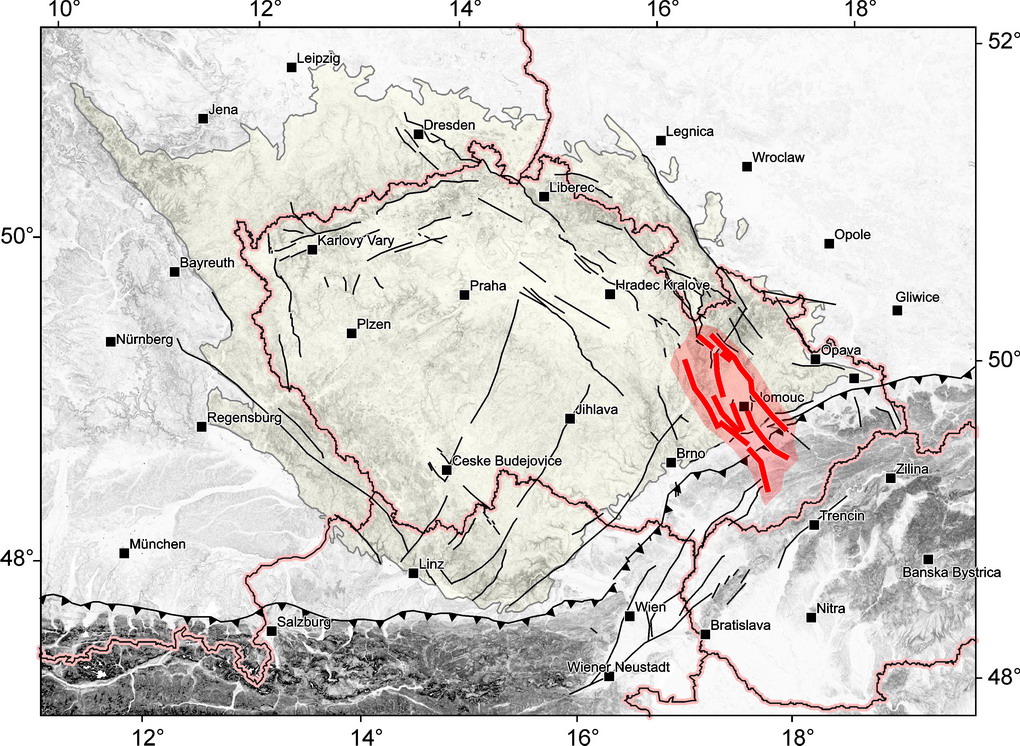
Haná Fault Zone (HFZ; term introduced by Mísař 1965) is a prominent NW-SE oriented, 30 to 40 km wide and at least 100 km long fault zone transecting the contact of the Bohemian Massif with the Outer Western Carpathians. Faults of NW–SE to N–S trends with large dip-slip component dominate. The HFZ coincides with distinct negative Bouguer gravity anomaly and hosts graben-like basins with Late Miocene to Middle Pleistocene sediment fill (the Upper Morava basin system; Růžička 1989, Špaček et al. 2015 and refs. therein).
HFZ is located in the southern part of seismically active region called the Nysa-Morava Zone (NMZ; Špaček et al. 2006, 2011, 2015) and it is formally delimited against the main part of NMZ (faults of the eastern Sudetes) by the Temenice Fault at the NE.
The SW limits against the aseismic region of southern Moravia is defined by the Nectava-Kvasice Fault System (link).
At the NW, the faults join those of the Bohemian Cretaceous basin and the limits of HFZ are formal there.
To the SE, the faults of HFZ continue into the flysch nappes of the Outer Carpathians, however, their role further to SE becomes unclear. The distribution of microearthquakes as well as the patch of volcanic rocks and springs of carbonated mineral water suggest increased mobility of NNW to NW striking faults far beneath the flysch zone. Disruption of transversally elongated gravity minimum of the Outer Carpathians in this direction suggests that this structure can continue towards the Pieniny Klippen Belt. Therefore, some faults in this region are included too and the HFZ, as defined here, extends between the towns of Moravská Třebová, Štíty, Šternberk, Lipník n. Beč., Fryšták, Luhačovice, Uherský Brod, Kroměříž and Konice.
Faults‘ structure, morphology and dip
HFZ is formed by a rather dense mesh of faults which have been mapped and linked together in various ways by different geologists. Some faults are associated with clear indications in gravity or magnetic fields, some form margins of deeper sedimentary grabens confirmed by drills.
Fault scarp morphology is assumed to be largely erosion-dominated (as I suggest for most scarps in CZ). Pronounced scarps, locally over 200 m high are developed on many faults which bound the basin against the bedrock (Temenice f., Droždín f., Morava river f., Kosíř f., Lutín f., Vitošov f. Bušín f.).
In geological maps most of the faults within the basin are not represented perhaps due to their weak indications at the surface. Here, I prefer interpreting all the more pronounced discontinuities as faults because UMB is perspective for research of young faulting and these structures should not be missed. On the contrary, in the SE part of HFZ likely more faults are present than defined here but only those with clear indications continuing over longer distance are currently included.
In our map, shorter faults are grouped formally into several larger fault structures where their collinearity allows it, for sake of simplicity of their naming. Some traditional names are adopted and some faults are given new names (these are marked by an asterisk in the list below).
The fault dip is inferred for some sections based mainly on ERT and few observations in trenches, or estimated from gravity field (via Linsser filtering). For some faults rough dip estimate is given based on the graben model. Reflection seismic profiles are not available in the north-western and central parts of the HFZ and they are mostly low resolution in the South-East.
Major faults:
- Bušín fault (BUS_1-3)

- Droždín fault (DRO_1-2)

- Holešov fault (HOL_1-12)

- Kosíř fault (KOS_1-9) Primarily defined at southern marginal fault of Kosíř elevation where the most intense research has been carried out. The results of trenching at two sites: Čelechovice CEL_B and Stařechovice STAR_A are described below. Mean fault dip of 70° is inferred from ERT profiles and trenches at KOS_1 section. Some landsliding is inferred at this section based on EM conductivity mapping and ERT profiles. Slope-related faulting is also indicated at Stařechovice (Špaček et al. 2017 and unpublished data).

- Lutín fault (LUT_1-2, 1a)

- Morava river fault (cze: zlom řeky Moravy; MOR_1-10)

- Nectava fault (cze: nectavský zlom; NEC_1-7;sometimes called Konice fault or undestood as a part of Nectava-Kvasice fault system together with Morava river fault)

- Nezdenice fault (NEZ_1) In SE part of HFZ, some carbonated mineral water springs collocated and Middle Miocene sub-volcanics likely associated with this fault (Krejčí and Poul 2010).

- Rozvadovice fault (ROZ_1, 1b) Still hypothetical but rather strongly supported by gravity field, local shallow ERT and topographical relief.

- Temenice fault (TEM_1-16)

- Vitošov fault (VITO_1-4)

Minor faults:
- Mostkovice fault (MOS_1-4)

- Příkazy fault (PRIK_1-2)

- Ruda fault (RUDA_1-2)

- Zvole fault (ZVO_1-5)

Seismicity
To be revisited after completion of earthquake catalogue. 
Pre-Miocene evolution

Fault activity in late Cenozoic
Tertiary

Quaternary

Related local evidence
(See layer Local evidence in the map. The sites are listed in south-to-north order.)
Brodek: Inferred faulting of strata
evi_ID: BRO-A
fsec_ID:
editor: Petr Špaček
Faulted high terrace gravel (Brodek terrace; Elsterian?) observed in trench and by drill survey. Agrees with reflection seismic profile. Macoun and Růžička (1967), Špaček et al. (2015).

Bohdašín: Microseismic cluster and ofset of river valley
evi_ID: BOH-A
fsec_IDs: TEM_2, TEM_1, TEM_2a, TEM_2b, TEM_2c
editor: Petr Špaček
Horsetail-like splay sections of Temenice fault adjacent to this point seem to offset the river valley (this likely relates to older tectonic phases + lithological control on river downcutting) and are collocated with microseismic cluster.

Čelechovice B: Observed faulted strata
evi_ID: CEL_B
fsec_ID: KOS_1
editor: Petr Špaček
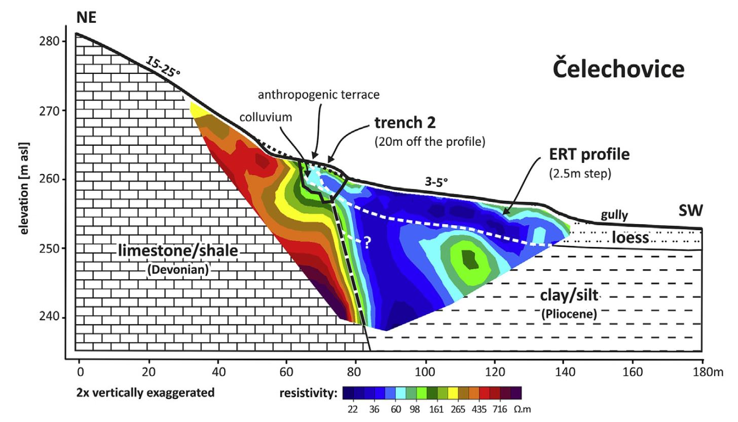
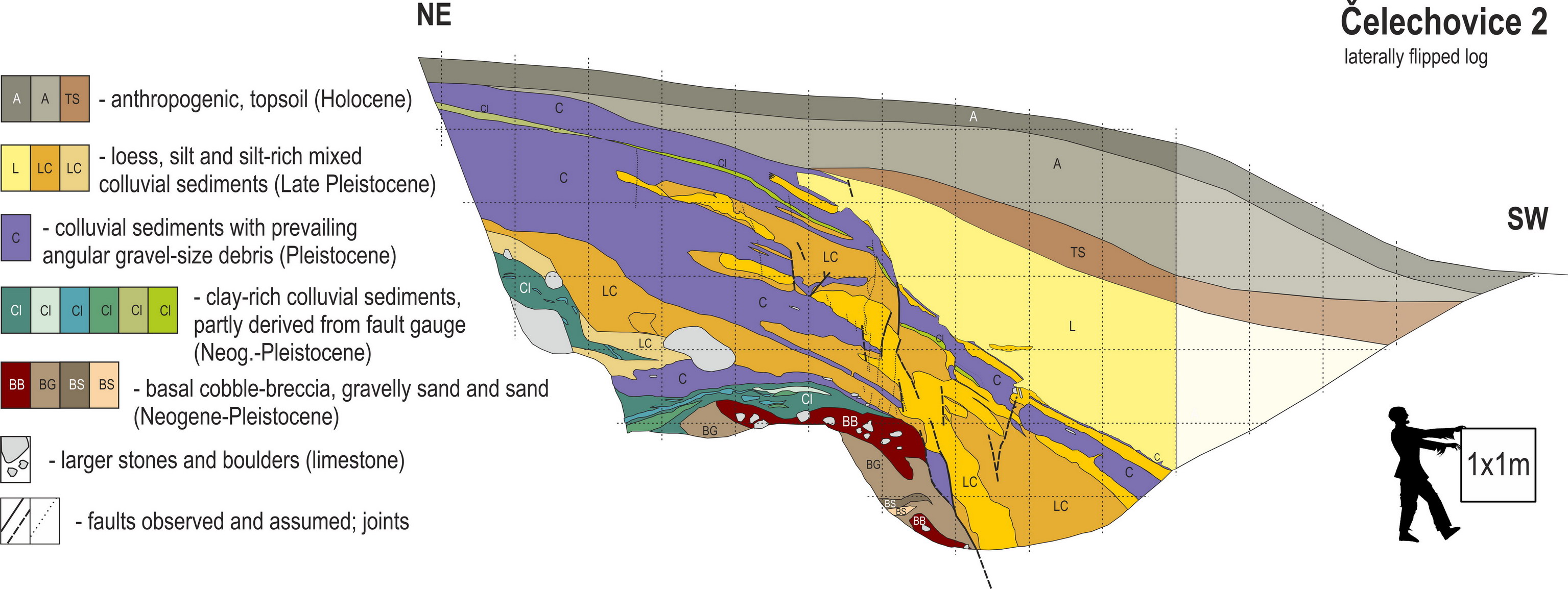
- Shorter of the two trenches at the site Čelechovice, 15 m long and 5-6 m deep; WGS84: 49.5278°N, 17.0830°E) at the foot of scarp with flat (5°slope) relief beneath. Slight anthropogenic modifications to shallow depth indicated. Trenching at this site was made to help unravelling the contributions of slope-related and tectonic faulting observed at STAR_A, as here no suitable conditions for deep-reaching slope deformation are expected.
- The succession of colluvia and loess exposed in a trench and a 16.8 m deep drill made ca 2 m downslope from the SW end of the trench was OSL-dated to give depositional ages of 38-62 ka for the colluvia and 20-24 ka for the loess (Špaček, unpublished).
- In the trench, the sedimentary sequence is cut by a NW-SE striking fault (here expressed as a loosely bound shear zone) dipping 70-75° to the SW, consistently with the the ERT profile.
- The coarse grained facies developed in the lower portion of the colluvial succession of the footwall block are missing in the hanging wall block. The boulders of limestone, likely representing the uppermost part of this facies, were reached at depth of 16.2 m by the drill. This suggests, consistently with the ERT profile, large apparent dip slip of ~16 m.
- The architecture of the middle part of the succession is only poorly correlated in the two blocks and the kinematics is therefore interpreted as an oblique normal fault with significant strike slip component. This implies that the 16 m slip is only a minimum value and the mean slip rate on the fault between ~62 and <20 ka must have exceeded 0.26 mm/a. Similarly as in STAR-A, deceleration of the fault slip towards the end of Pleistocene is suggested by small offset of the loess base and undisplaced topsoil observed in trench CEL-B.
- See more details in Špaček et al. 2017. New data to be published in 2021.
Čelechovice profile with ERT, interpreted geology and position of the trench. Note vertical exaggeration. From Špaček et al. 2017.
Javoříčko: Broken speleotheme
evi_ID: JAV-A
fsec_ID:
editor: Petr Špaček
Pre-60 ky fracturing of speleothems interpreted as seismogenic by Bábek et al. (2015).

Lutín: Inferred faulting of strata
evi_ID: LUT-A
fsec_ID: LUT_1
editor: Petr Špaček
Displaced Kralice terrace of assumed Holsteinian-Middle Saalian age. Locally confirmed by detailed drill survey. Růžička (1973), Špaček et al. (2015)

Luběnice: Inferred faulting of strata
evi_ID: LUB-A
fsec_ID: LUT_1
editor: Petr Špaček
Displaced Kralice terrace of assumed Holsteinian-Middle Saalian age. Locally confirmed by detailed drill survey. Růžička (1973), Špaček et al. (2015)

Mladeč: Broken speleotheme
evi_ID: MLA-A
fsec_ID:
editor: Petr Špaček
Pre-60 ky fracturing of speleothems interpreted as seismogenic by Bábek et al. (2015).

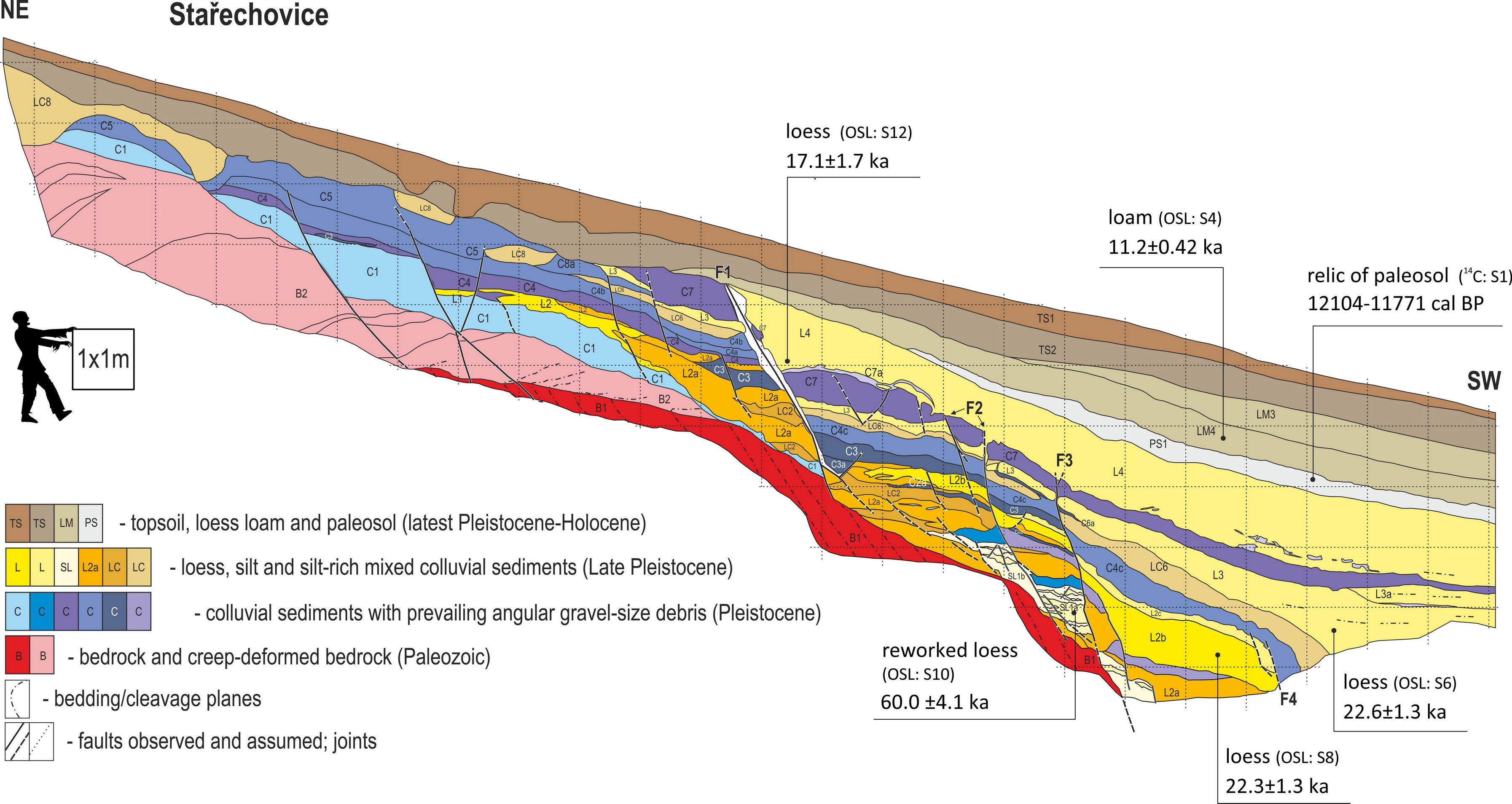
Stařechovice: Observed faulted strata and sealing strata
evi_ID: STAR_A
fsec_ID: KOS_1
editor: Petr Špaček
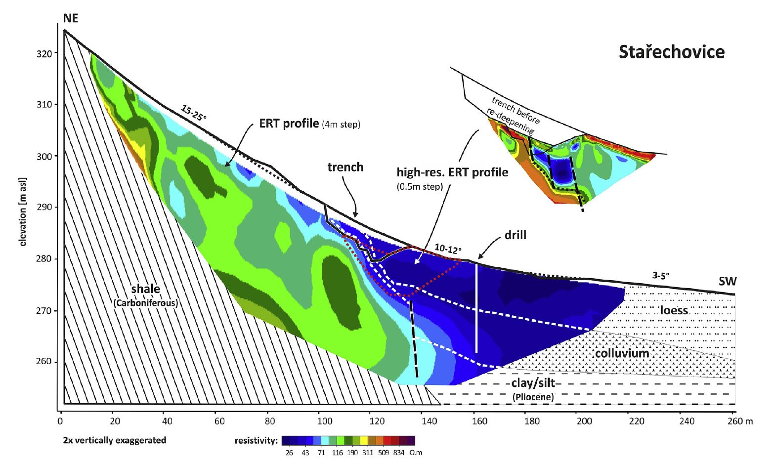
- Trench near Stařechovice (30 m long and 4-6 m deep; WGS84: 49.5348°N, 17.0639°E) located in a relatively steep slope (~15°) with >17 m thick sediment accumulation verified by a shallow drill. This was the first trench made at Kosíř fault in 2014.
- The succession of several generations of 12-75 ka old loess with paleosol and colluvia on top of the bedrock is disrupted by numerous moderately to steeply (60-80°) dipping synthetic faults and minor antithetic faults, both exhibiting dip slips ranging from <1 cm to 1.4 m. Prevailing normal slip with significant horizontal component was inferred for major faults.
- Observations in trench indicate fast faulting prior to 21-23 ka (estimated av. slip rate of >1mm/a at fault F3), deceleration to 0.2-0.3 mm/a in period 17-11 ka (fault F1 with youngest slip of min. 1.4 m) and absence of significant slip after 11 ka.
- In spite of inferred prevailing tectonic origin of these faults, some structures indicate significant detachment and shear deformation at the base of Quaternary strata and likely slope-related deformation. The situation does not allow to simply separate the effects of tectonic slip and the hypothetical near-surface slope related slip at this site alone.
- Despite the lack of clear colluvial wedges indicative of local differential erosion at broken surface we cannot rule out the episodic deformation related to strong earthquakes.
- See more details in Špaček et al. 2017.
Stařechovice profile with ERT, interpreted geology and position of the trench. Note vertical exaggeration. From Špaček et al. 2017.
Main data sources for fault map
…
Other notes
…
References
- …
