Table of Contents
Diendorf - Boskovice fault system
Structure ID: DBF
Fault Section IDs: DF_1-10; BF_1-17; WEI_1-3
Related terms: Diendorf fault (ger: Diendorfer Störung), Boskovice Graben fault (cze: okrajový zlom boskovické brázdy), Weitzendorf fault (ger: Weitzendorfer Störung; cze: weitzendorfský zlom)
Editor: Petr Špaček
First published: Aug 2019 | Last update: 29. 5. 2024
General description
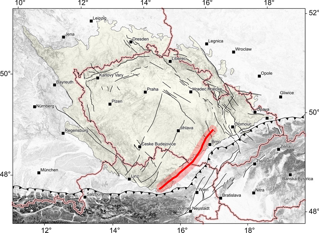
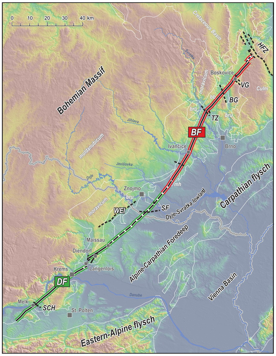
Diendorf-Boskovice fault system (DBF) is more than 200 km long fault structure running in the general NE-SW direction from the Alpine thrust front in Austria to the transverse faults of the Haná fault zone in the Czech Republic. It is formed by two major faults: the Diendorf fault (DF) to the south and the eastern marginal fault of the Boskovice half-graben, here termed the Boskovice Graben fault (BF), to the north (Fig. 1). Physical linking of both faults in the flat area of the Alpine molasse/Carpathian foredeep basins is strongly supported by geophysical data (see Špaček at el. 2018). Here, the formal border between DF and BF is located in the external part of the Carpathian foredeep basin. Southwestward continuation of DF beneath the Alpine nappes is unclear. To the north-northeast the BF is terminated by cross-cutting faults with apparently younger slip (the Haná Fault Zone). The parallel Weitzendorf fault and some minor faults (not necessarily included in the database) are formally assigned to DBF.
Fault structure and dip
At shallow levels the fault is always steep, dipping either due W or E or vertical in both BF and DF. At general scale the BF is expected to be steeply inclined to WNW. The azimuth of the fault trace ranges between <20° and >45°.
- At BF, steep dip to the west (Zapletal 1924, 1929, Polák 1959) or east (Suess 1907; Zapletal 1924; Jaroš 1958) were observed. In case of the latter, observations of overturned Permian strata were reported from the fault neighborhood (Jaroš 1958). In the Miroslav horst and further south (BF_1 and 2) a steep western dip is indicated by natural outcrop in an erosional gully, observations in trenches and shallow geophysical profiles (Lesonice, Kadov and Hostěradice; Špaček et al. 2015a, 2017, 2018).
- In the commonly adopted models of the Boskovice graben (Jaroš 1961a; Malý 1993; Jaroš & Malý 2001) the BF is shown as a steeply east-dipping fault. However, it must be stressed that clear evidence for deeper geometry is missing and these models should be taken as the authors' concepts. The seismic reflection profile referred to by the authors was made at a short line south of Rosice (Štelcl et al. 1985). Primary data is unavailable but generally low quality is expected considering the technical setting of the survey and the published line-drawing of the profile.
- The importance of thrust component repeated in literature seems to me overrated. Local variations observed near the surface could partly represent flower structures related to the expected prevailing strike-slip kinematics of the post-Stephanian fault displacements.
- At DF, rare observations were reported from excavation near Maissau (DF_4; Posch-Trotzmüller and Peresson 2012) and quarry Limberg (DF_4 to 5; secondary faults; Decker 1999). In both cases the faults are close to vertical.
The fault core, where observed, is often built by several meter wide mélange with fragments or bodies of limestones and greywackes (sections BF_2 through BF_14; Špaček et al. 2002) locally containing dark coloured clays. Surface observations near Zöbing (vineyards north of Kammern) suggest that the strongly deformed zone may be >10 m broad there. Similar width is expected elsewhere in Permian and crystalline rocks. In trench near Hostěradice, a 5-6 m wide zone of strong shearing and additional >5 m wide damage zone with dense small-scale faults is exposed in Lower Miocene clays and sands. The former contains frequent small fragments of weathered crystalline rocks.
A <20 to 250 m wide damage zone of the main fault is documented in Early Miocene sediments across a large part of BF_1 section by EM conductivity mapping (Fojt and Špaček, unpublished) and by observations in aerial photographs.
Parallel fault sections (splays of primary fault) are indicated by geological mapping and relief morphology in some parts of DF and BF, in a zone up to 800 m wide. Multiple parallel and oblique faults (observed and assumed) located in a broader zone (within up to 10 km to both sides of the BF and DF) indicate distributed faulting reflecting the complexity of long term evolution in different stress fields.
Cross structures and Segmentation
Cross structures, mostly of general NW-SE strike, traverse the DBF at multiple places, preferentially at its northern, Czech part. These are mainly (from north to south):
- Fault-bounded Valchov and Blansko „grabens“ (Fig. 1) representing subsided blocks with preserved Upper Cretaceous sediments (e.g. Kettner 1941, Zvejška 1944, Skoršepa and Melichar 2017). These important structures directly disrupt the BF and bring evidence against significant horizontal slip in the northern part of the BF (sections BF_10 through BF_14) after the formation of the depressions in their present-day shape. The sediments of the Blansko depressions are likely disrupted by normal faults collinear with the BF (section BF_11, so called Klemov fault). Relict Miocene sediments are present in both depressions.
- Minor cross faults of NW-SE to NNW-SSE direction along the whole eastern margin of the Boskovice graben (BF_3 through BF_15) are often drawn in geological maps and mentioned in texts. They are reported to offset the Permian-Carboniferous fill of the basin both at the surface and in coal mines (např. Čepek 1946, Polák 1954, Jaroš 1960, 1961, 1964a, 1972c). However, their position and geometry differ substantially in different maps and hence I assume they are difficult to trace and probably had very small slip in most cases (comp. Jaroš and Malý 2001).
- Three zones of low relief with relics of Miocene sediments cross the BF in its central and southern parts: The Tišnov-Kuřim zone, the Jihlava river valley near Ivančice and the southern margin of the Boskovice graben. These structures represent either tectonically subsided areas or erosional paleovalleys or combination of both. Post-Early Badenian vertical slip was inferred in the Tišnov-Kuřim fault zone (Fig. 1; currently not included in database) where Early Badenian sediments are juxtaposed to Eggenburgian/Ottnangian ones along a fault of NW-SE strike (Hanžl et al. 2001a). Similarly, at the southern margin of the Boskovice graben (between Rakšice and Lesonice), NW-SE trending faults seem to terminate the relic of Badenian sediment and small-scale slip at one of these cross faults was observed to offset Early Miocene strata in a trench (Prachař et al. 2017a).
- Lower Miocene and relict Middle Miocene sediments of the Dyje-Svratka Lowland (Fig. 1) cover the fault sections DF_6 through DF_8 and BF_1. These sediments represent marginal facies of Alpine-Carpathian Foredeep. It is likely that the sediments are part of subsided area affected by normal faulting (comp. Dlabač et al. 1969, Dlabač 1976, Prachař 1970a, 1970b, Čtyroký 1982). ERT measurements made at two topolineaments near Hnízdo and Strachotice (Špaček et al. 2016) likely indicate faults with substantial offset of strata. Small scale faults are documented at localities Lechovice and Stošíkovice. However, faults with significant slip have never been observed directly and there is no geophysical indication of clear significant offset in a map. Therefore, only small slip and/or prevailing normal slip component must be assumed.
- One of the more expressive faults in the Dyje-Svratka Lowland with larger normal slip component has been reported as the Slup fault (Fig. 1; Buday et al. 1963; Kalášek et al. 1963, Batík et al. 1970, 1977, Dornič et al. 1984, 1985a,b; currently not included in the database). It has been drawn in geological maps between Šatov, Hnízdo and Slup, with general N-E strike, crossing the DF_6 section. Its geometry, however, seems to be poorly constrained. Based on drills, relative vertical offset of 100-150 m has been inferred between the southern, subsided block with Karpathian sediments and the northern block with only Eggenburgian-Ottnangian sediments preserved.
 Segmentation near Langenlois.
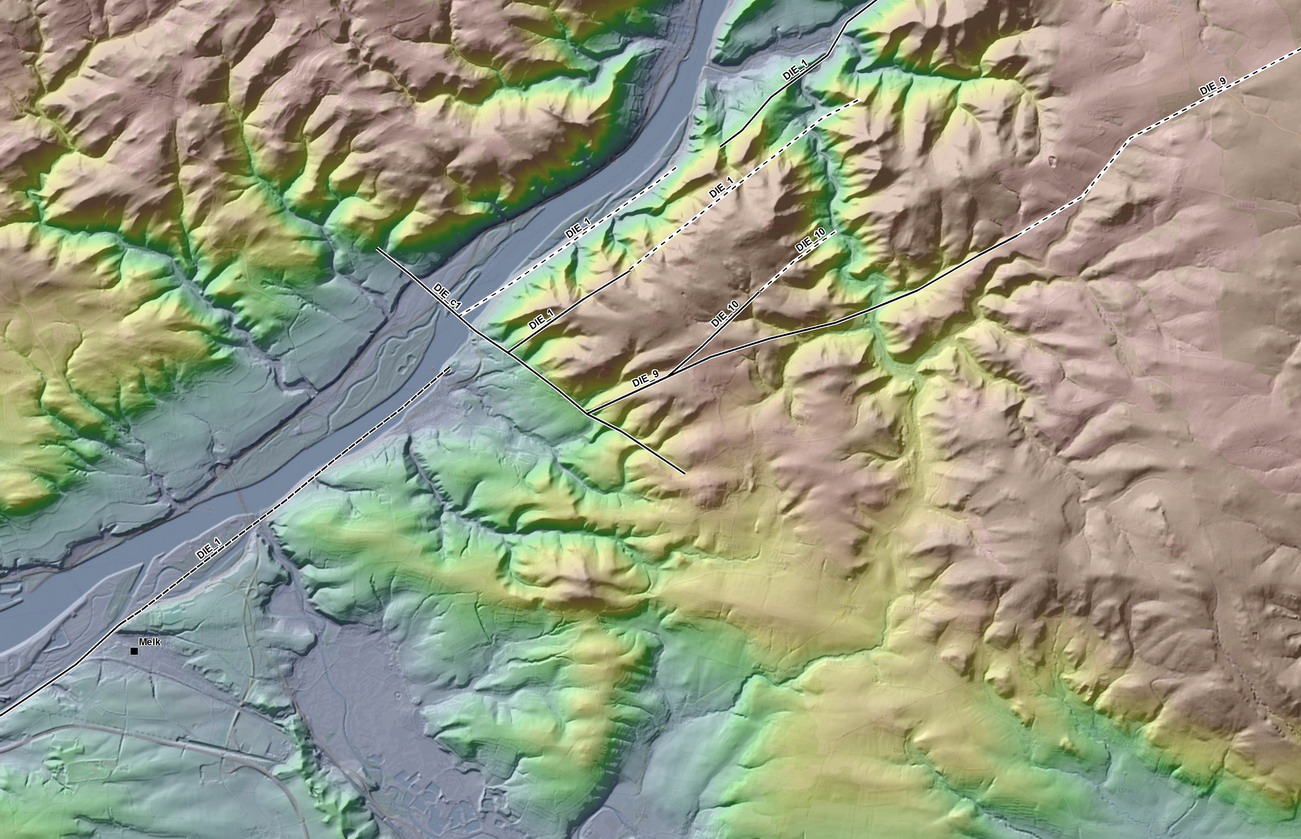
 - South of Melk, near Schönbühel a.d. Donau (Fig. 1), a pronounced scarp of WNW-ESE direction, very likely a fault, crosses the DF. As it is not offset by the DF, it provides evidence against significant strike slip at sections DF_1, 1a and 9.
Fig.1. Schematic map of DBF with some basic features mentioned in text: Acronyms alphabetically: bb – Boskovice graben, BF – Boskovice graben marginal fault, BG – Blansko graben, DF – Diendorf fault, HFZ – Haná fault zone, mh – Miroslav horst, SCH – scarp near Schönbühel, SF – Slup fault, TZ – Tišnov—Kuřim zone, VG – Valchov graben, WEI – weitzendorf fault.
Scarp morphology
Surface morphology at the fault trace varies significantly, largely due to different degree of differential erosion at contacts of rocks with similar vs. contrasting mechanical properties.
- Well developed linear fault scarp is observed where Lower Miocene sediments were juxtaposed to crystalline rocks due to the fault slip and were later partly or entirely denudated (fault sections DF_4, BF_2 and very likely DF_1.2 through 1.4). The scarp of fault section BF_2 exhibits number of gullies with disequilibrium profiles breaking at the fault line, suggesting fast fall of erosional base (which I interpret as due to fast erosional exhumation of the old fault scarp; see Fault activity in late Cenozoic.
- Eroded scarp is common in parts with relics of Middle Miocene sediments on bedrock (sections BF_3, 5, 9, 10.1, 16 through 17) and with increased local river erosion (sections DF_1.5 and BF_7 to 8).
- Inexpressive to absent scarp is characteristic for large parts of the Boskovice graben where Permian clastic sediments are in contact with crystalline or Carboniferous greywackes and no larger rivers are present (sections BF_4, 6 through 8, 10, 12, 14 to 15).
- In parts where Mesozoic and Tertiary sediments are present at both sides of the fault line the scarp is entirely absent (sections DF_2, 5, 6, 8, BF_1, 11 and 13).
Observed seismicity
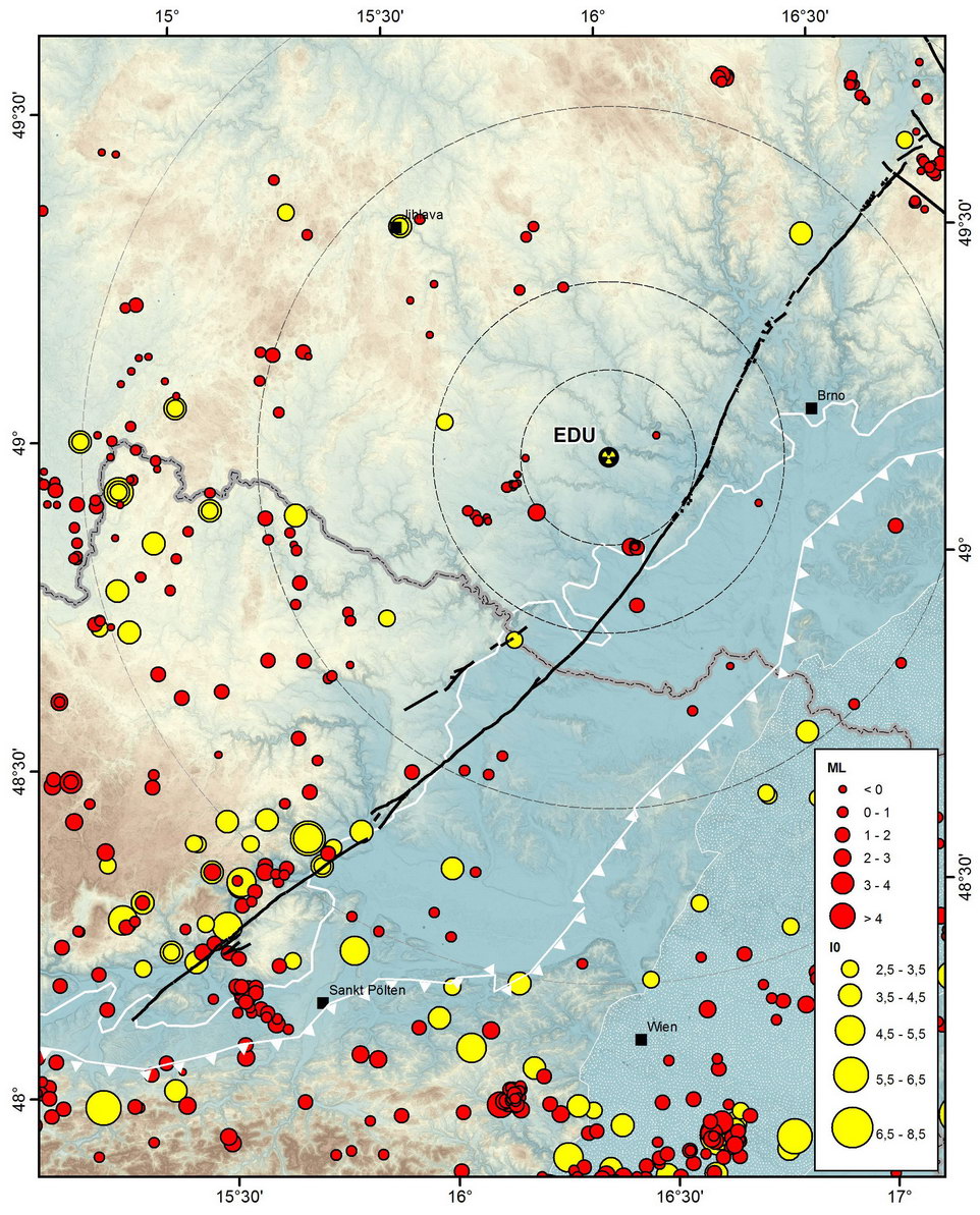
This section will be revisited after completion of earthquake catalogue (submitted deliverable of Prachař and Pazdírková for WP1)! It is now based on review in Lenhardt et al. (2007) and preliminary compilations of ZAMG Vienna and IPE Brno (Pazdírková, unpublished) - see Fig. 2.
- Repeated occurrence of weak earthquakes near the southern part of DF is most noticeable feature along the whole DBF. This cluster of epicentres seems slightly anomalous even on the scale of the southernmost Bohemian Massif. Maximum macroseismic intensities observed for earthquakes near Krems and Melk are I0=5-6° EMS-98 (largest intensity reported earthquake near Senftenberg in 1959). The corresponding estimated maximum magnitude is Mw≈3.5
 .
. - Coverage by seismic stations of this part of Austria has been loose until recently and large location errors in order of several kilometres must be expected for older instrumentally recorded earthquakes. The error of location exceeding 10 km should be considered everywhere for historical earthquakes based on infrequent macroseismic observations. Our knowledge on the earthquake foci spatial distribution is still too poor to allow clear identification of the active structure, however, its association with DF (sections DF_1a, 1 and 2) is not unlikely.
- Few other known instrumentally or macroseismically recorded earthquakes are scattered along DBF, with magnitude up to ML=2.5 (near Hostěradice, >3 km away from BF_1 and BF_2; years 2000 and 2014) and (I0=4-5° (near Kunštát, <6 km away from BF_11; year 1916).
- In general, modern seismicity along BF and northern DF is very weak and similar to background seismicity both in terms of rate and magnitude.
Pre-Miocene evolution
- Both DF and BF have been considered major structures with partly shared evolution since the early geological research (e.g. Suess 1926, Shermann 1966, Jaroš & Mísař 1967, Matura 1976, Figdor and Scheidegger 1977).
- DBF corresponds with the surface trace of Variscan terrane boundary between Brunovistulicum and Moldanubicum. It also correlates with western termination of the Lower Carboniferous flysch (comp. Melichar 1995), i.e. the root zone of Variscan externide nappes.
- Significant synsedimentary slip with vertical component (>1600m) took place at BF during Upper Carboniferous-Permian and produced the Boskovice half graben with StephanianC-Autunian sedimentary fill. Fans of coarse Rokytná conglomerates are associated with BF-bounded eastern margin of the graben. This faulting is assumed to be of normal geometry, related to orogen gravitational collapse (e.g. Jaroš 1961a, Malý 1993, Jaroš and Malý 2001). Locally, dikes and sills of basalt-andesite (sub-)volcanics were observed to penetrate the sediments (e.g. Přichystal 1994). Relic of Permian sediments near Zöbing suggests that analogical subsidence may have been associated with northern/central part of DF.
- Locally observed steep reverse geometry at BF (e.g. Suess 1907, Zapletal 1924, Jaroš 1958, Jaroš 1962) and the intra-basin deformation structures (reverse faults and long wavelength folds, Jaroš a Malý 2001) indicate post-Permian compression or transpression. The age of this phase is unknown and likely pre-Cretaceous as no corresponding structures were observed in Cretaceous strata (Zapletal 1924).
- At DF, strike-slip geometry is accentuated with cumulative post-Variscan (post-collision) left-lateral slip estimated in the range 25-70 km (as inferred from offset of crystalline bodies with mutual affinity; Schermann 1966; Matura 1976; Figdor and Scheidegger 1977).
Fault activity in late Cenozoic
Tertiary
- The post-Eggenburgian/Ottnangian (post-earlier Burdigalian) slip is indisputable for the southern part of Diendorf-Boskovice fault as far as to section BF_3. This is based on direct observations of faulted rocks and geophysical observations of the sharp and steeply dipping contacts of Lower Miocene (Eggenburgian, Ottnangian) sediments with crystalline at segments DF_4,5,7 and BF_1 to 3.
- Strike-slip or oblique slip kinematics is evidenced by fault striations and structure (Kadov and Hostěradice sites at BF_1 and 2; Limberg site near DF_5) but complex kinematics with changing geometry can not be ruled out.
- More precise time constraint of this phase of activity is problematic as a sound evidence from relics of Karpatian and early Badenian (late Burdigalian to early Langhian) is not available and younger Tertiary sediments are missing regionally. I assume, basing on a regional tectonic model and some local observations, that the activity peaked near the early/middle Miocene boundary and ceased towards later Badenian (younger-than-late Badenian faulting on a similarly oriented fault is documented e.g. in Troskotovice pit, situated 11 km to the east of DF).
- Significant large scale post-Badenian strike-slip at DBF is
 counterevidenced by cross structures described above. The transverse Valchov and Boskovice “grabens” (BF_10,11,13) with well defined, fault-bounded margins and Cretaceous and early Badenian sedimentary fill practically rule out the strike-slip taking place at the northern part of BF after early Badenian (the latter have been locally mapped as continuous bodies on top of BF). Some other depressions (valleys) crossing the central and southern parts of BF and hosting concentrated relics of early and middle Miocene fine clastic sediments (depressions near Čebín, BF_8 to BF_10; Jihlava river valley near Ivančice, BF_5,6; Lesonice depression, BF_3) also do not show any signs for horizontal offset and thus testify against large-scale strike slip.
 - Termination of the early Miocene strike-slip phase at BF is further affirmed by development of a system of small-amplitude faults with average NW-SE strike. On the DF such faults are not present in geological maps, however, they are often clearly indicated in relief (e.g. near Schönbühel a.d. Donau).
- In the Dyje basin crossing the DBF in segments DF_6-8, post-Lower Miocene faulting is indicated by apparent strata cut-offs at several ERT profiles crossing some major topolineaments in the basin (Špaček et al. 2016). Steeply dipping faults of WNW-WSE to NNW-SSE strike were described from near Stošíkovice na Louce.
- Magnitude and timing of dip-slip component is difficult to constrain at most fault sections as the data on well dated stratigraphic bases of Tertiary deposits on the fault are insufficient.
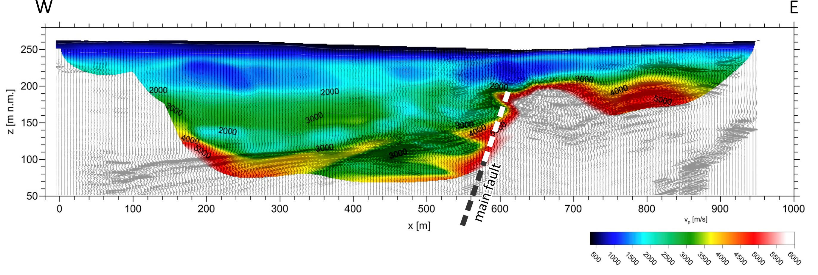
- At fault sections BF_1 (Lesonice) and BF_3 (Hostěradice), however, high resolution refraction seismic survey combined with ERT and seismic reflection (Alexa 2017) shows clearly a fault-related vertical offset of >50m at the base of low-velocity layer (assumed Early Miocene and/or strongly weathered crystalline). Furthermore, at Lesonice profile a pediment (or paleovalley bottom) developed in crystalline and covered by non-offset strata of assumed Eggenburgian/Ottnangian age indicates the
 termination of vertical-component faulting during or before the Lower Miocene deposition (while the smaller scale strike-slip component is not ruled out).
Quaternary
Following evidence is considered in the assessment of Quaternary activity:
- Continuity of overlying strata
- The sealing strata observed in detail in trenches in sections BF_1, BF_2 (Hostěradice and Kadov) bring
 evidence against surface fault slip after ~23 ka.
 - Termination of older strata in Kadov trench on a fault plane allow considering slip with min. vertical component of 2 m in 100 - <23ka time window, however, the non-tectonic model of origin of this structure is preferred (see references for site Kadov) as the tectonic origin would be in conflict with observations at adjacent segments.
- Sealing strata in a trench at DF_7 (Tasovice) bring
 local evidence against surface fault slip after at least 100 ka and probably much longer.
 - Vertically non-displaced base of high terrace and its relics mapped in detail in section BF_4 (site Budkovice) brings
 evidence against vertical slip component larger than approx. 1 m since the deposition. The assumed age of the terrace is late Early to early Middle Pleistocene based on regional model of a fluvial terrace system evolution.
 - Likewise, vertically non-displaced base of high terrace between villages of Dyje, Lechovice, Božice and Hodonice (“Hodonice fluvial level”) brings
 evidence against vertical slip component larger than approx. 2-3 m at section DF_8 since late Early to early Middle Pleistocene.
- Geomorphology
- Total absence of systematic horizontal offsets of geomorphological features (or any other piercing lines), including the deeply incised cross-cutting valleys in hard rocks (mainly BF_2, 4, 8, 12), brings
 evidence against significant active horizontal slip since river incision in Middle Pleistocene.
 - The fault scarp morphology reflects the lithologically controlled denudation rather than young or even ongoing dip-slip. Best developed linear scarps are present in those sections where the fault line corresponds with the contact of Early Miocene sediments with crystalline rocks. Conversely, scarp is never developed in soft sediments, regardless of whether young cover is present or absent. Therefore, scarp morphology does not provide clues on Quaternary slip. However, the features of scarps at sections DF_4 and BF_2 require fast exhumation. The disequilibrium profiles in erosional gullies breaking at the fault line at section BF_2 are interpreted as due to fast erosional exhumation of the old fault scarp. Significant contribution of active vertical tectonic slip is considered unlikely as it would make this fault section anomalous in the regional context.
- Seismicity and paleoseismicity
- A cluster of epicentres of weak earthquakes between the towns of Langenlois, Gfohl, Ybbs an der Donau and Melk (see Observed seismicity) suggest possible relation to southern Diendorf fault (sections DF_1, 2, 5 and 6). However, the causality is unclear as the cluster shape (possibly affected by poor accuracy of location) allows for different conclusions. In the area of southern Bohemian Massif the increased seismicity seems to be characteristic. Some observations suggest that unmapped NW-SE striking faults may be responsible for at least part of these earthquakes (see site Schönbühel a.d. Donau as an example). The concerned sections of DF are admitted to take part in this deformation but activation of large segments by a single earthquake seems unlikely.
- To the north of Langenlois the low number and magnitude of historical and instrumental earthquakes and their low spatial correlation with fault line do not allow affiliation of seismicity to any known structures.
- Rare local observations of soft sediment deformation structures are interpreted as due to paleoearthquakes with minimum intensity of 6-7° (sites Lechovice and Tasovice). The source of these hypothetical earthquakes is entirely unknown and they are not necessarily related to Diendorf fault. In case of epicentre located close to observation sites, the minimum magnitude of Mw=5 should be considered.
- Geodesy
- Results of some long-term geodetic measurements in the region were interpreted as tectonic deformation in several studies (Pospíšil et al. 2009, 2010, 2012; Roštínský et al. 2013). However, editor of this text is skeptical to interpretation of these observations as due to tectonic strain because:
- the reported strain rates and slip rates are too large (slip rate of 10-1 mm/y, i.e. same order as the faults in the eastern Alps) to be in agreement, on a regional scale, with concept of active Alpine orogen vs. stable foreland;
- the locally observed geological records rule out that such deformation at BF could have been operative on a long-term scale during Quaternary;
- the non-tectonic deformation (climatic/hydrogeological, slope instability, problematic long-term stabilization of measurement points) of the surface is expected to compete with such strain rates or exceed them (see the extensive literature on the effects of water management and climatic change on surface deformation and Vyskočil 1996). For example, repeated levelling on a profile crossing the BF near Tetčice (section BF_6; Roštínský et al. 2013) and suggesting vertical slip rate of 10-1 mm/y order, was partly carried out in the area of former pond (see maps of the 1st military mapping from 1764-1768) and therefore likely affected by ongoing sediment compaction.
![]() Basing on this local evidence the fault activity is currently evaluated in a following way:
Basing on this local evidence the fault activity is currently evaluated in a following way:
- In the southern part of DBF, the sections DF_1 to BF_2 are ranked class 3, i.e. assumed or admitted to be active but without direct evidence. Quaternary slip rate at fault sections north of DF_3 is assumed very low (<0.01 mm/y). Southern sections may later be ranked class 1 (demonstrably active) when new earthquake data (better location, focal mechanism) bring clear evidence.
- In the northern part of DBF, the sections BF_3 to BF_ 17 are ranked class 4, i.e. assumed or demonstrated to be inactive.
On a theoretical basis, the evaluation of similarly oriented sections of DBF by different activity ranks may be justified by:
- expected northward decrease of rate of stress build-up (and hence crustal strain rate), and
- expected northward decrease of slip potential due to rotation of stress orientation near junction of the Alpine and the West-European stress domains.
Related local evidence
(See layer Local evidence in the map. The sites are listed in south-to-north order.)
Schönbühel a.d. Donau: Cross-structure
evi_ID: SCHO_A
fsec_IDs: DF_1, DF_1a, DF_9
editor: Petr Špaček
- Pronounced scarp of WNW-ESE direction dividing the hilly terrain with narrow valley of Danube to the NE from comparatively flat area with wide Danube valley to the SW. Interrupted and multiple topolineament continues in ESE direction towards Hafnerbach, partly reflecting the structure of the crystalline basement. This scarp, very likely a fault (not identified in geological maps), possibly a minor dip-slip fault once terminating now eroded Tertiary Molasse sediments or thick regolith, seems to lack any horizontal offset by Diendorf fault (sections DF_1, 1a and 9), therefore providing evidence against significant strike slip of the latter after the formation of the former.
- This structure is likely a part of a system of WNW- to NW- striking faults with small slip amplitude documented by multiple observations and indicated by penetrative presence of topolineaments in an extensive area hosting the whole DF and southern BF. The age of these faults is largely unknown but some of them were observed to displace Quaternary strata. In Dunkelsteiner Wald and Wachau this fault system may host sources of weak seismicity.
- Also note the N-S oriented topolineaments near Aggasbach Dorf north of here which seem to coincide with deflected valley of Danube river (out of extent of the map shown here).
Limberg: Secondary faults. Timing of dip-slip
evi_ID: LIM_A
fsec_ID: DF_4
editor: Petr Špaček
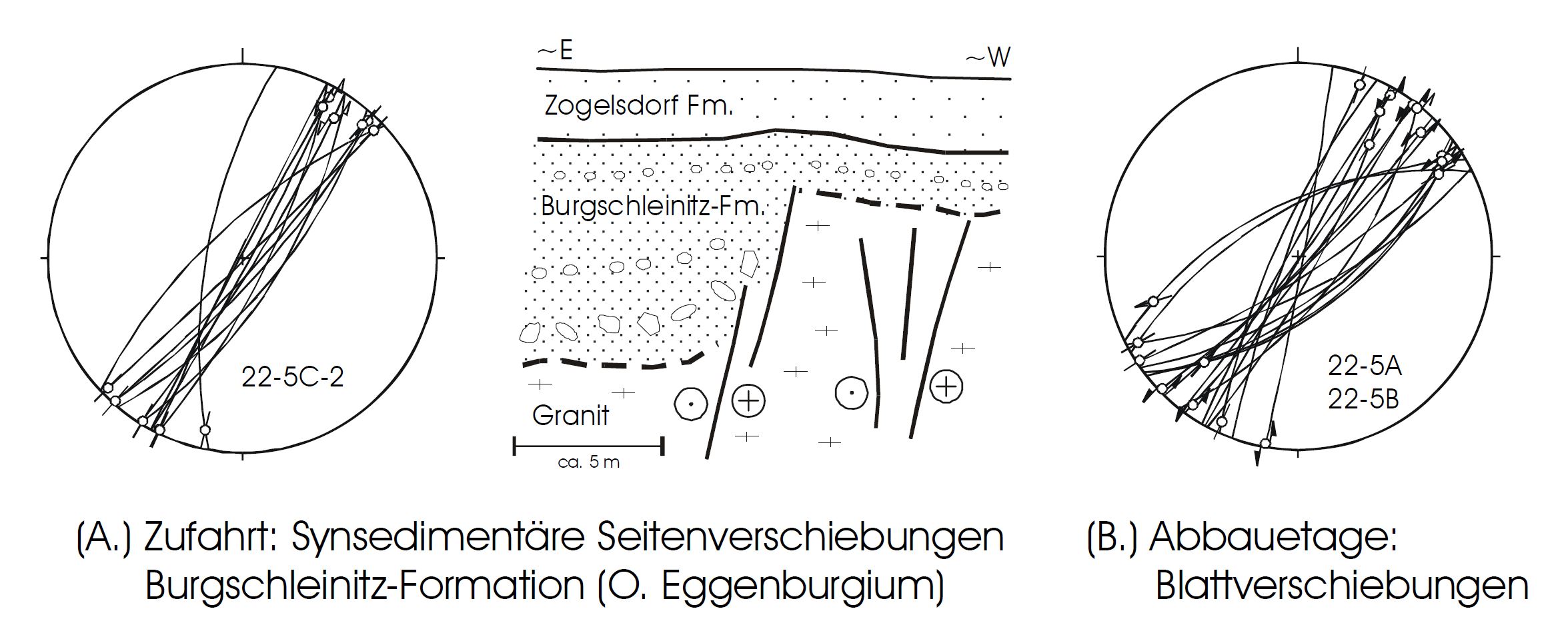
- Early Miocene synsedimentary faulting near Diendorf fault - parallel secondary faults in Hengel quarry in Limberg (Decker 1999). Faults are steep, on stereodiagrams they seem to be vertical on average with strike-slip kinematics. Both the faulted lower and the non-faulted upper parts of sedimentary sequence were dated as Eggenburgian.
Tasovice: Observed sealing strata and inferred paleoearthquake
evi_ID: TAS_A
fsec_ID: DF_7
editor: Petr Špaček Ivan Prachař
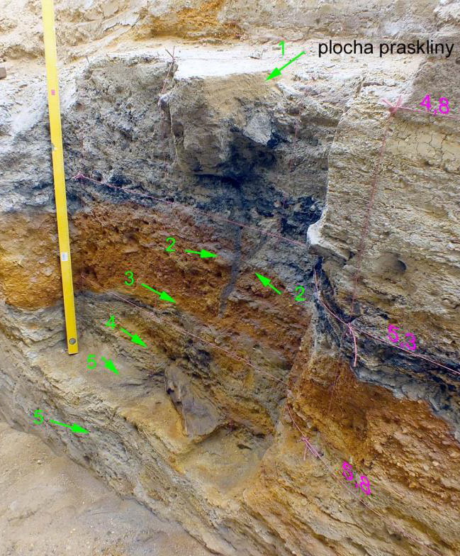
- Trench RTAS-3 (length 39 m, max. depth 7.5 m; at profile with several trenches and drills) with sedimentary sequence sealing the bedrock with Diendorf fault, here exposed as broad shear zone juxtaposing metaconglomerate and mylonite.
- The 7 m thick sediment succession includes (from bottom to top; see photo an scheme below left): sandy eluvium, coarse gravels (partly cemented), silty clays with angular detritus, layer of colluvium, fine loams with paleosol, and loess loams to loess with interlayer of laminated or cross bedded fine sands. While the layers no. 6 and 7 (see figure) give OSL ages within the span of 36-63 ka, dating of the deeper strata remains problematic. Ages largely exceeding 100 ka are very likely and Tertiary age is not ruled out (Prachař 2017).
- Clay-filled fault within the shear zone contains slickenside (dipping 66° to NW) with 2 sets of slickenlines, the younger showing normal dip-slip. The fault does not continue to the covering sediment (Prachař 2017).
- Thin blind sand dike cuts through the lower part of the sedimentary sequence above the fault. The dike connects directly to the fault, but no systematic offset of hosting strata was observed, only local disturbation of single bed of coarse sand adjacent to the dike (Prachař 2017).
- This clastic dike is interpreted as an effect of local liquefaction generated by earthquake-induced shaking. Its location above the observed fault is likely an effect of stress concentration within loose and water-saturated deposit above the breakpoint in bedrock topography and lithology (structurally controlled failure of gravitationally unstable sediment) as the coseismic slip at the fault (dynamic control) is ruled out by the absence of strata offset (Špaček et. al. 2018).
- Although the inferred hypothetical earthquake is not necessarily related to Diendorf fault, it is recommended to be assumed related for purpose of SHA (Špaček et. al. 2018).
Lechovice: Cross-structure and inferred paleoearthquake
evi_ID: LECH_A
fsec_ID: BF_1
editor: Petr Špaček
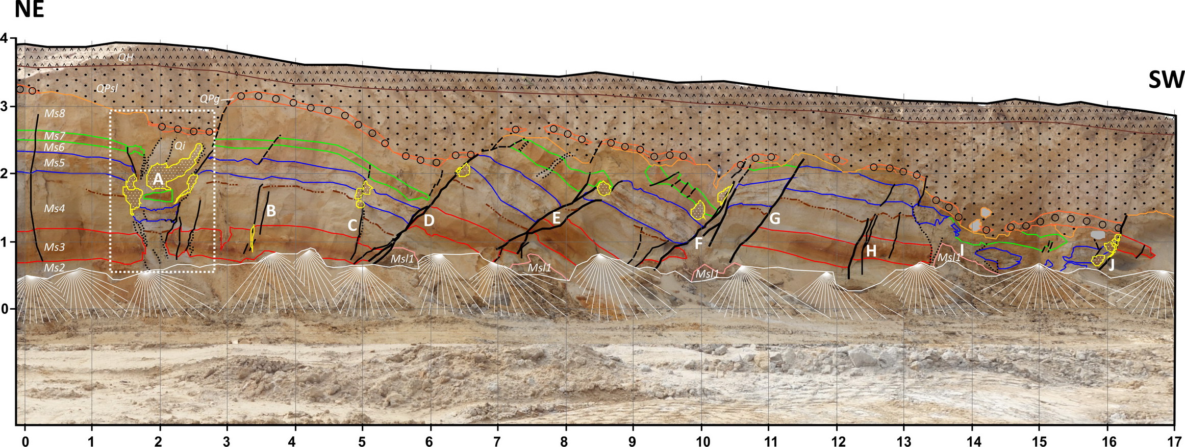
- Roadcut (presently rehabilitated) situated ~1.5 km from the Diendorf fault line. System of NNW-striking normal faults displacing Lower Miocene sands (Ms1-8) and Quaternary fluvial sandy gravels (QPg; below left) associated with sand intrusions (Qi; yellow patches in figure below left and detail view on photograph below right). All feeder dikes are blind. Strong block rotation on the observed faults, formation of small-scale graben structures and collocation with sand-intrusions suggest formation by lateral spreading, possibly near-synchronous with deposition of Early to early Middle Pleistocene terrace. The causal link between the hypothetical earthquake and the Diendorf fault or the NW-SE to NNW-SSE oriented cross-faults has not been resolved. The observed faults are similarly oriented as those at Stošíkovice (below) and also sub-parallel to local scarp and to general-scale trend of the Jevišovka river valley. Structural control of the observed faults by either of these features and later reactivation by lateral spreading is possible. (Špaček et al. 2018)
Stošíkovice: Cross-structure
evi_ID: STOS_A
fsec_ID: BF_1
editor: Petr Špaček
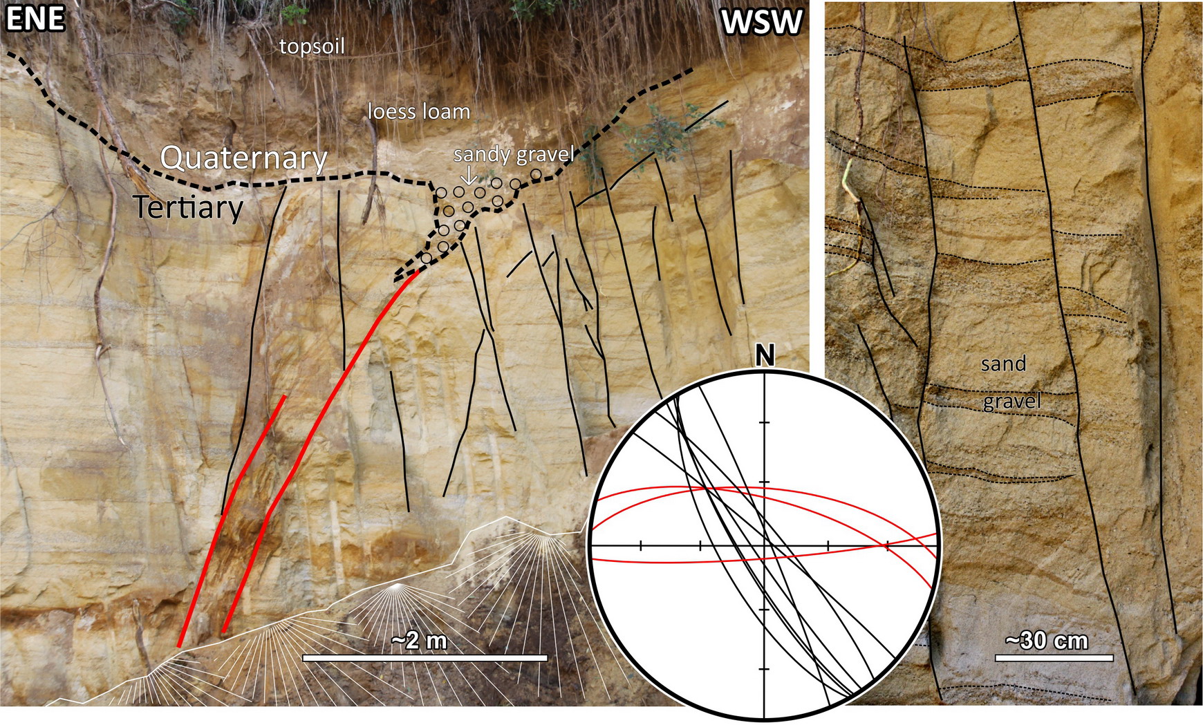
- Small sand pit in L. Miocene sands situated ~250 m from the Diendorf fault line. WNW-WSE striking fault with incorporated gravel of high terrace relic (explained either by active faulting or structurally controlled cryoturbation) and a system of older, small-displacement, NW-SE to NNW-SSE trending faults (Špaček et al. 2015b). These faults are probably a part of important larger-scale cross-structure of the Dyje basin (link Cross-structures and Segmentation) which may and may not include the faults near Lechovice (see above).
Hostěradice: Observed sealing strata
evi_ID: HOS_A
fsec_ID: BF_1
editor: Petr Špaček
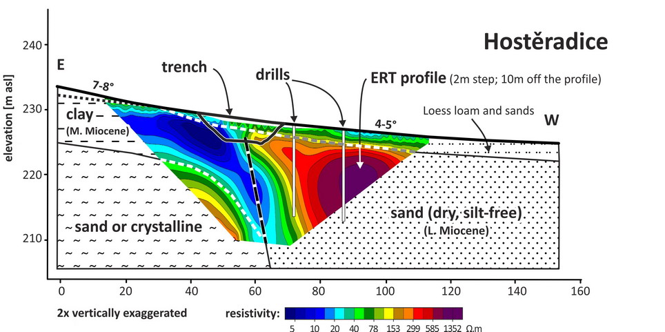
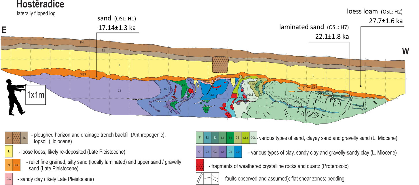
- Trench HOS-1 (25 m long and 4 m deep; WGS84: 48.9476°N, 16.2726°E) with fault in Lower Miocene sediments sealed by Late Pleistocene sands and loess loam. Špaček et al. (2017, 2018)
- Strong imbrication, large density of deformation bands and content of tectonic clasts of kaolinized crystalline rocks at the contact of clays and sands indicate large slip on the fault after deposition of Miocene sediments (assumed age Eggenburgian-Ottnangian based on lithostratigraphic correlation). Horizontal slip component was inferred on small faults which offset the thin clayey beds in sands, but the sense of slip was not resolved.
- Deformed Neogene sediments are unconformably overlain by Pleistocene strata. The irregular, up to 30 cm thick basal layer of sands and gravelly sands with mostly angular clasts of local provenance has a sharp base and the luminescence dating of a single sample gives the age of 16-18 ka. Locally, at the base of Quaternary a thin sub-horizontal layer of parallel-laminated sand is developed and partly incorporated in coherently bended or apparently undeformed parts of Miocene sand. Luminescence age of a single sample from this layer is 20-24 ka.
- The above described sediments are overlain by 1-1.8 m thick layer of loess loam which is mixed with sands at the base. Its luminescence age is 26-29 ka. This age inversion (if real) suggests the emplacement of the loess loam without resetting of the luminescence signal (e.g. in a form of mudflows derived from older loess). Apparent age inversion due to dating errors can not be ruled out, however.
- These observations together provide evidence against episodic surface fault slip, both vertical and horizontal, at least since 16 ka.
- Younger slope-related deformation reaching the depth of 3 m is indicated by small-scale sub-horizontal shear zones, bending of Miocene strata and wedge-shaped apophyses of Quaternary sand and silt incorporated to small scale NW- to SW-vergent thrusts which fade out within first 85 cm below the surface of Miocene strata.
Hostěradice profile with ERT, interpreted geology and position of the trench. Note vertical exaggeration. From Špaček et al. 2017.
Kadov: Observed sealing strata
evi_ID: KAD_A
fsec_ID: BF_2
editor: Petr Špaček
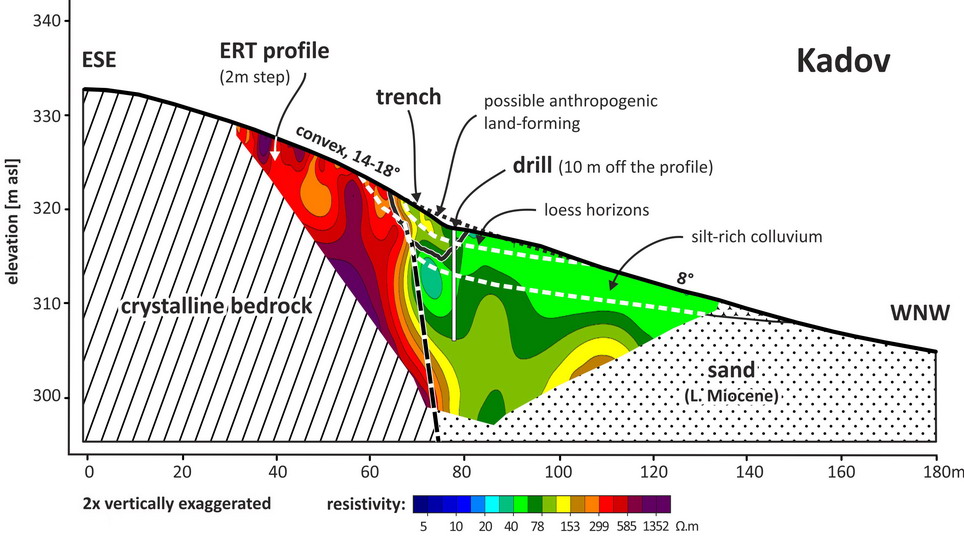
- Trench KAD-1 (20 m long and 4 m deep; WGS84: 48.9747°N, 16.2937°E) situated at the foot of a relatively low scarp with local slope of 14-18°. The exposure of fault contact crystalline vs. E. Miocene sediment in an erosional gully some 120 m NE from here provided steep fault with slickensides and striations plunging 50° to the NNE.
- The trench exposed a steep fault dipping 75° to the NW with crystalline bedrock in a footwall and Neogene sands in the hanging wall, consistently with two ERT profiles made at the site.
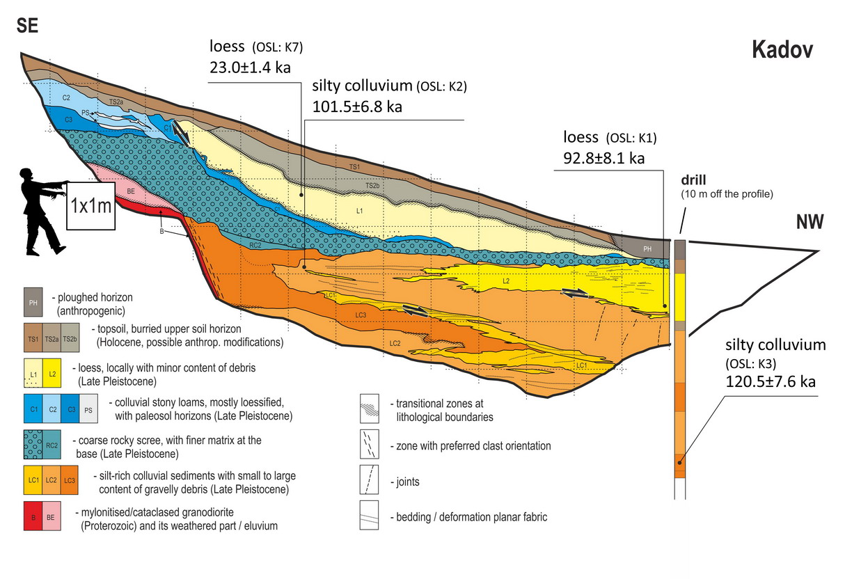
- The fault in the trench is sealed by the 22-24 ky old loess (OSL) and by the non-dated pre-loess scree providing evidence against episodic surface fault slip, both vertical and horizontal, at least since LGM. The origin of coarse scree horizon is assumed to be climatically controlled (via frost shattering in cold and humid climate, likely pre-LGM).
- The silt-rich colluvium beneath the scree, OSL-dated at 85-128 ka (incl. 1 sigma uncertainty) terminates on a sharp and steep contact with cataclased mylonite of granitic protolith. This sediment is strongly deformed (likely by gelifluction but shaking effect is not ruled out) resulting in jagged bedding planes and locally well developed lamination. This penetrative shear deformation seems to have partly affected the overlying strata, likely resulting in the listric termination of top loess in direct continuation of the step in the bedrock.
- Shallow drill located near the lower end of the trench shows that the thickness of this Pleistocene succession is 5 m and it is underlain by 2.5 m-thick loamy sands of uncertain age and the fine sands of assumed Lower Miocene age.
- Total absence of any discrete faults or joints applies to whole exposed part of Quaternary sediment.
- Problematic is the 20 cm broad contact zone of older part of colluvia with the bedrock where increased content was observed of cm- to dm-size slab-shaped clasts oriented parallel with steep bedrock surface. This can be explained either as due to detachment of pieces of jointed bedrock into the colluvium by repeated freezing and thawing or as a result of shear deformation. In the latter case, fault slip in the time range 100 to <23 ka (pre-dating the formation of scree layer) would be likely. However, we did not observe any slickensides or other macroscopic signs of shear deformation within this zone and failed to obtain any data on its microscopic internal structure wherefore its origin can not be resolved.
- From Špaček et al. (2017, 2018)
Profile Kadov with ERT, interpreted geology and position of the trench. Note the vertical exaggeration. From Špaček et al. 2017.
Lesonice: Eroded fault scarp, Timing of last dip-slip
evi_ID: LES_A
fsec_ID: BF_3
editor: Petr Špaček
- Refraction and reflection seismic profile crossing the fault line (Alexa 2017; diploma thesis supervised by J. Valenta) showing a >50 m vertical offset at the base of low-velocity strata (assumed Lower Miocene sediment and/or strongly weathered crystalline) and a >40 m thick, apparently vertically undisplaced, top layer with even lower velocity, covering this offset and a buried pediment in crystalline rocks. The upper sedimentary body is of assumed Eggenburgian/Ottnangian age (~17-21 Ma) and it fills up adjacent paleovalley. The structure documents the erosional destruction of older fault scarp near (or in) the paleovalley and the absence of vertical slip component on the fault after Early Miocene (which is the minimum age of the paleovalley). Note the qualitative similarity of this observation with that at Limberg site. Small younger horizontal slip is not ruled out here.
Budkovice: Sealing strata
evi_ID: BUD_A
fsec_ID: BF_4
editor: Petr Špaček
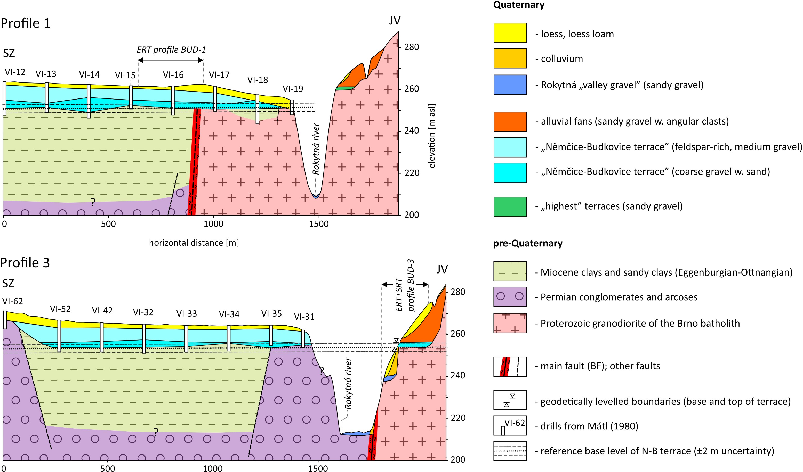
- Gravels of high level river terrace (40-50 m above present floodplain) with base well defined by drill survey (Mátl 1980), detailed mapping (Špaček et al. 2015a, 2015b) and levelling survey (Špaček and Zacherle 2017) serve as alostratigraphic marker providing evidence against vertical slip on the Boskovice graben fault since the deposition.
- The continuous terrace body is either observed to seal the fault locally (see profile 1 below) or its separated relics are at the same height on both sides of the fault (profile 2). The terrace base is undisplaced within the precision of its definition which is 2 m.
- The age of gravel stratum is estimated from its relative height at Lower to early Middle Pleistocene, based on regional correlation scheme of Zeman (1984). Assuming the uncertainties of age and maximum offset, the maximum average slip rate at this section of BF is calculated at <0.003 mm/year.
- At the same locality (and many other places along the fault), talwegs of numerous valleys deeply incised in bedrock crossing the fault as well as contours of plateaus between, lack any (a fortiori systematic) offset on the fault in the highly accurate DEM, suggesting that horizontal slip must have been small ( likely <0.01 mm/year) or zero since the start of incision in Middle Pleistocene.
- More detailed summary in Špaček et al. (2018)
Main data sources for fault map
Geological maps and explaining texts:
- scale 1:25000:
- sheet 34-133 Hatě (Čtyroký et al. 1978, 1987; Batík et al. 1978)
- sheet 34-132 Božice (Dornič et al. 1983, 1984)
- sheet 34-131 Šatov (Batík et al. 1977, 1982, 1983)
- sheet M-33-117-C-a Šatov (Dlabač et al. 1970)
- sheet M-33-117-C-b Jaroslavice (Batík et al. 1972)
- sheet 34-114 Prosiměřice (Dornič et al. 1985a,b)
- sheet 34-113 Znojmo (Čtyroký et al. 1978, 1983a,b)
- sheet 34-112 Miroslav (Dornič et al. 1987)
- sheet M-33-117-B-a Miroslav (Dornič 1972)
- sheet M-33-105-D-c Moravský Krumlov (Dlabač et al. 1975)
- sheet M-33-105-D-b Ivančice (Jaroš 1964a,b)
- sheet 24-341 Oslavany (Buriánek et al. 2011a,b)
- sheet M-33-105-B-d Rosice (Jaroš et al. 1972c)
- sheet M-33-105-B-b Veverská Bitýška (Mísař and Jaroš 1972; Jaroš et al. 1972a,b)
- sheet 24-321 Tišnov (Hanžl et al. 2001a,b)
- sheet 24-322 Blansko (Hanžl et al. 2000a,b)
- sheet M-33-94-A-d Knínice z Boskovic (Dvořák et al. 1964)
- scale 1:50000:
- sheet 37-Mautern (Matura et al. 1983)
- sheet 23-Hadres (Rötzel et al. 2007)
- sheet 22-Hollabrun (Rötzel et al. 1998)
- sheet 21-Horn (Frasl et al. 1991)
- sheet 9-Retz (Rötzel et al. 1999)
- sheet 34-13 Dyjákovice (Čtyroký et al. 1987; Müller et al. 2003)
- sheet 34-11 Znojmo (Matějovská et al. 1988; Müller et al. 2002)
- sheet 24-33 Moravský Krumlov (Matějovská et al. 1991)
- sheet 34-12 Pohořelice (Havlíček et al. 1988; Müller et al. 1995)
- sheet 24-34 Ivančice (Pálenský et al. 1994; Müller et al. 1994; Batík et al. 1994)
- sheets 24-32, 24-14, 24-23, 24-21 (ČGS 2014)
- scale 1:200 000: sheet Niederösterreich Nord (Schnabel 2002)
- special maps: (Čížek 1976; Mátl 1980; Kolektiv 1994; Špaček et al. 2015, 2016)
Geophysics:
- Regional gravimetry a aeromagnetic survey (compiled maps of Švancara in Špaček et al. 2018; Blaumoser 1992)
- Local airborne magnetic and electromagnetic survey (DF_5, WEI_2; Sieberl et al. 1996, 1997)
- Local gravimetry (DF_1 to DF_5, Figdor and Scheidegger 1977; BF_7-10, Halíř et al. 1987)
- Electrical resistivity tomographic profiles, seismic refraction and reflection profiles (Valenta and Tábořík et al. in Špaček et al. 2016, 2018 and references therein; Alexa 2017)
- Local high-resolution electromagnetic conductivity survey between Hostěradice and Lechovice (BF_1; as yet unpublished data by Fojt and Špaček)
- Vertical electrical sounding in the sediments on sections DF_6-8, BF_1 and BF_9,10 (Kraus 1989, Synek 1980, Hron 1980, Bláha a Synek 1987, none of these surveys have good enough resolution and none of them shows changes of physical properties or structure which could be associated with the fault).
Other:
- DEM: Lidar based models of the Czech Republic (DMR4g and 5g; ČÚZK 2013, 2016) and Lower Austria
- Drill survey: mainly shallow drilling (mostly from CGS/Geofond archive, see references in Špaček et al. 2015b)
Other notes
Ongoing research and possible future work to be done:
- EM conductivity mapping of fault and covering sediments south of Hostěradice (Fojt and Špaček, ongoing), near Ivančice, Lesonice and Bořitov (planned)
- studies on cross structures
References
- Alexa, M. (2017): Studium Diendorf-Boskovické stuktury pomocí geofyzikálních metod. Diplomová práce MS. PřF UK Praha.
- Batík, P., Dlabač, M., Gabriel, M., Neubauer, M., Zeman, A. (1970): Vysvětlující text k základní geologické mapě 1:25 000 M-33-117-C-a Šatov. MS, ČGS – Geofond, Praha.
- Batík, P., Dlabač, M., Dudek, A., Skořepa, J., Zeman, A. (1972): Vysvětlující text k základní geologické mapě 1:25 000 list M-33-117-C-b Jaroslavice. MS, ČGS – Geofond, Praha.
- Batík P. et al. (1977) : Vysvětlivky k základní geologické mapě 1:25000 list 34-131 Šatov. ÚÚG Praha.
- Batík, P. et al. (1978): Vysvětlivky k základní geologické mapě 1:25 000 34-133 Hatě. ČGS/Geofond, Praha.
- Batík, P. et al. (1982): Vysvětlivky k základní geologické mapě ČSSR 1:25 000; 34-131 Šatov. ÚÚG, Praha.
- Batík, P. et al. (1983): Geologická mapa ČR 1:25 000, list 34-131 Šatov. ÚÚG, Praha.
- Bláha, V. and Synek, V. (1987): Neogénní sedimenty jihozápadní části karpatské předhlubně (reinterpretace). Geofyzika Brno, GF P055751.
- Blaumoser N.H. (1992): Eine erste gesamte aeromagnetische Karte von Österreich und ihre Transformationen. Mitt. österr. geol. Ges. 84 (1991), 185-203.
- Buday, T. et al. (1963): Geologická mapa ČSSR 1:200.000, list Brno. ÚÚG, Praha.
- Buriánek, D. et al. (2011a): Základní geologická mapa České republiky 1:25 000, list 24-341 Oslavany. Česká geologická služba. Brno.
- Buriánek, D. et al. (2011b): Vysvětlivky k základní geologické mapě České republiky 1 : 25 000 list 24-341 Oslavany. Závěrečná zpráva, 257 s. MS, Česká geologická služba.
- Čepek, L. (1946): Tektonika boskovické brázdy. – Věst. Ústř. Úst. geol., 20, 128-130. Praha.
- ČGS (2014): Bezešvá geologická mapa 1:50 000. Česká geologická služba, Praha. On-line, http://mapy.geology.cz/geocr_50/
- Čížek, P. (1976): Mapování a vývoj miocénních sedimentů v okolí Ivančic a Oslavan. MS, Přírodovědecká fakulta MU, Brno.
- Čtyroký, P. et al. (1978): Geologická mapa ČR 1:25 000, list 34-133 Hatě. ÚÚG, Praha.
- Čtyroký, P. et al. (1978): Vysvětlivky k základní geologické mapě 1:25 000 34-113 Znojmo. Ms. ČGS – Geofond, P000169/1978, Praha.
- Čtyroký, P. et al. (1983a): Geologická mapa ČR 1:25 000, list 34-113 Znojmo. ÚÚG, Praha.
- Čtyroký, P. (1982): Spodní miocén (eggenburg a ottnang) jz. části čelní hlubiny na Moravě. – Zem. Plyn Nafta, 27, 4, 379–394.
- Čtyroký, P. et al. (1983b): Vysvětlivky k základní geologické mapě ČSSR 1:25 000; 34-113 Znojmo. ÚÚG, Praha, 80 s.
- Čtyroký, P. et al. (1987): Vysvětlivky k základní geologické mapě ČSSR 1:25 000; 34-133 Hatě. ÚÚG, Praha, 22 s.
- Čtyroký, P. red. (1987): Geologická mapa ČR 1:50 000, list 34-13 Dyjákovice. ÚÚG, Praha.
- ČÚZK (2013): Digitální model reliéfu ČR 4. generace. Český úřad zeměměřický a katastrální, Praha.
- ČÚZK (2016): Digitální model reliéfu ČR 5. generace. Český úřad zeměměřický a katastrální, Praha.
- Decker, K. (1999): Tektonische Auswertung integrierter geologischer, geophysikalischer, morphologischer und strukturgeologischer Daten. (Projekt N-C-036/F/98 Geogenes Naturraumpotential Horn-Hollabrunn). Ms. Geol. B.-A., Wien.
- Dlabač, M., Gabriel, M., Homola, V., Martinec, P., Neubauer, M., Zeman, A. (1969): Základní geologická mapa 1:25 000 list M-33-117-A-b Višňové (s vysvětlivkami). Ms. ČGS – Geofond, Praha.
- Dlabač, M., Batík, P., Gabriel, M., Neubauer, M., Zeman, A. (1970): Vysvětlující text k základní geologické mapě 1:25 000 M-33-117-C-a Šatov. MS, ČGS – Geofond, P022311, Praha.
- Dlabač M., Jaroš J., Matějovská O. (1975): Základní geologická mapa 1:25 000 M-33-105-D-c Moravský Krumlov s vysvětlivkami. Ústřední ústav geologický Brno.
- Dlabač, M. (1976): Neogén na jihovýchodním okraji Českomoravské vrchoviny. Výzk. práce ÚÚG, 13, 7–21.
- Dornič J. (1972): Základní geologická mapa 1:25000, list M-33-117-B-a (Miroslav) a vysvětlivky. Ústřední ústav geologický Praha.
- Dornič, J. et al. (1983): Geologická mapa ČR 1:25 000, list 34-132 Božice. ÚÚG, Praha.
- Dornič, J. et al. (1983): Geologická mapa ČR 1:25 000, list 34-132 Božice. ÚÚG, Praha.
- Dornič, J. et al. (1984): Vysvětlivky k základní geologické mapě ČSSR 1:25 000; 34-132 Božice. ÚÚG, Praha.
- Dornič, J. et al. (1985a): Geologická mapa ČR 1:25 000, list 34-114 Prosiměřice. ÚÚG, Praha. Geofond, P110641, Praha.
- Dornič, J. et al. (1985b): Vysvětlivky k základní geologické mapě ČSSR 1:25 000; 34-114 Prosiměřice. ÚÚG, Praha, 50 s.
- Dornič, J. et al. (1987): Geologická mapa ČR 1:25000, list 34-112 Miroslav. ÚÚG, Praha.
- Dvořák J., Jaroš J., Malecha A. 1964: Geologická mapa M-33-94-A-d (Knínice u Boskovic). Přírodovědecká fakulta UK. Praha.
- Frasl, G., Fuchs, G., Höck, V., Rötzel, R., Steininger, F., Vasicek, W., Vetters, W. (1991): Geologische Karte Blatt 21 Horn, 1:25 000. Geologische Bundesanstalt, Wien.
- Halíř, J. et al. (1987): Gravimetrické mapování v měřítku 1:25 000 v oblasti Tišnov - Veverská Bítýška. Geofyzika Brno. MS Geofond, GF P057141
- Hanžl P. et al. (2000a): Vysvětlivky k základní geologické mapě ČR 1:25000, 24-32 Blansko. Český geologický ústav, Praha.
- Hanžl P. et al. (2000b): Základní geologická mapa České republiky 1:25 000. List 24-322 Blansko Český geologický ústav, Praha.
- Hanžl P. et al. (2001a): Vysvětlivky k základní geologické mapě ČR 1:25000, 24-321 Tišnov. Český geologický ústav, Praha.
- Hanžl P. et al. (2001b): Základní geologická mapa České republiky 1:25 000 List 24-321 Tišnov. Český geologický ústav, Praha.
- Havlíček, P. et al. (1988): Geologická mapa ČR 1:50 000, list 34-12 Pohořelice. ÚÚG, Praha.
- Hron, J. (1980): Hydrogeologie karpatské formace. Geoelektrické měření 1977–1979. Ms. ČGS – Geofond, Brno.
- Janoštík, M. (1975): Zpráva o geofyzikálním průzkumu kvartéru v oblasti Hodonice – Kyjovice. Ms. ČGS – Geofond, P024455, Praha.
- Janoštík, M. (1977): Zpráva o geofyzikálním průzkumu kvartéru v oblasti Valtrovice – Božice. Ms. ČGS – Geofond Praha. P023891
- Jaroš, J. (1960): Mapování jižního konce Boskovické brázdy v okolí Moravského Krumlova. – Zpr. geol. Výzk. v Roce 1958, 65-67. Praha.
- Jaroš, J. (1961): Geologický vývoj jižní části Boskovické brázdy (oblast Moravský Krumlov – Veverská Bitýška) v permokarbonu. Práce brněn. zákl. ČSAV, 33, 12, spis 425, 545–569.
- Jaroš J. (1964a): Podklad pro geologickou mapu 1 : 50 000 list Ivančice - mapa s vyhodnocenými technickými pracemi. Listy M-33-105-D-c (Moravský Krumlov) a M-33-105-D-b (Ivančice). MS UK Praha
- Jaroš J. (1964b): Vysvětlivky ke geologické mapě 1 : 50 000 list Ivančice M-33-105-D. Část Permokarbon boskovické brázdy. MS Geofond CGS P000124/1964
- Jaroš, J. et al. (1972a): Vysvětlivky k základní geologické mapě 1 : 25 000 (M-33-105-B-b) Veverská Bítýška. – Archiv ČGÚ. Praha.
- Jaroš, J. et al. (1972b): Zpráva o mapování na listu M-33-105-B-d (Veverská Bitýška). – MS PřF UK. Praha.
- Jaroš, J., Mísař, Z., Nekovařík, Č., Zeman, A. (1972c): Základní geologická mapa 1: 25 000 list M-33-105-B-d (Rosice). UK Praha.
- Jaroš, J. and Malý, L. 2001. Boskovická brázda. In: Pešek J. et al. (eds.): Geologie a ložiska svrchnopaleozoických limnických pánví České republiky. ČGÚ Praha.
- Kalášek, J. et al. (1963): Vysvětlivky k přehledné mapě 1:200.000, list Brno. ÚÚG, Praha, 256 s.
- Kettner, R. (1941): Blanenský prolom. – Sbor. Čes. společ. zeměp., 46, 113–118. Praha
- Kolektiv (1994) Soubor map a vysvětlivek z mapovacího kurzu posluchačů geologie PřF MU. (vedení R. Melichar). Manuskript MU Brno.
- Kraus, L. (1989): Zpráva o geofyzikálním měření na akci Lechovice - Hrušovany (hydrogeologie). MS Geofyzika Brno, GF P065662.
- Lenhardt, W., Švancara J., Melichar P., Pazdírková J., Havíř J., Sýkorová Z. (2007) Seismic activity of the Alpine-Carpathian-Bohemian Massif region with regard to geological and potential field data. Geol Carpathica 58 (4):397–412.
- Matějovská, O. red. (1988): Geologická mapa ČR 1:50 000, list 34-11 Znojmo. ÚÚG, Praha.
- Matějovská, O. et al. (1991): Geologická mapa ČR 1:50 000, list 24-33 Moravský Krumlov. ÚÚG, Praha.
- Mátl, V. (1980): Syrovice – Ivaň, vyhledávací průzkum živcové štěrkopísky. Ms. ČGS – Geofond, Praha.
- Matura A., Fuchs. W., Grill. R. (1983): Geologische Karte der Republik Österreich 1:50000, 37 Mautern. Geologische Bundesanstalt Wien.
- Melichar R. and Čech. S (1999): Stop 7. Blansko - Dolní Lhota. Abstracts of Contributions and Excursion Guide to the 4 th Meeting of the Czech Tectonic Studies Group (Česká Tektonická Skupina, Associated to the Czech Geological Society held in Blansko-Češkovice on April 15-18, 1999, Geolines 8, 90.
- Mísař Z. and Jaroš Z. (1972) Základní geologická mapa M-33-105-B-b (Veverská Bítýška). UK Praha.
- Müller V., Batík P., Čurda J., Kašpárek M., Lysenko V., Maňour J., Pálenský P., Růžička M., Růžičková B., Tomášek M. (1994): Vysvětlivky k souboru geologických a ekologických účelových map přírodních zdrojů v měřítku 1:50000- List 24-34 Ivančice. ČGS Brno.
- Müller, V. et al. (1995): Vysvětlivky k souboru geologických a ekologických účelových map přírodních zdrojů 1:50 000; 34-12 Pohořelice. ČGÚ, Praha.
- Müller V. et al. (2002): Vysvětlivky k souboru geologických a ekologických účelových map přírodních zdrojů 1:50 000; 34-11 Znojmo. ČGS, Praha.
- Müller V. et al. (2003): Vysvětlivky k souboru geologických a ekologických účelových map přírodních zdrojů 1:50 000; 34-13 Dyjákovice. ČGS, Praha.
- Pálenský, P. red. (1994): Geologická mapa ČR 1:50 000, list 24-34 Ivančice. ČGÚ, Praha.
- Polák, A. (1954): Průzkum cementářských surovin 1952–1953 Chudčice. – MS Geofond. Praha.
- Posch-Trotzmüller G. and Peresson M. (2012): Geologische Bearbeitung kurzfristiger Aufschlüsse in Niederösterreich mit Schwerpunkt auf infrastrukturelle Bauten in schlecht aufgeschlossenen Regionen und auf rohstoffwissenschaftliche, umweltrelevante und grundlagenorientierte Auswertungen Neue Bauaufschlüsse – Neues Geowissen: Niederösterreich Projekt NC 69 / 2009-2011 Jahresendbericht 2011. Geologische Bundesanstalt Wien.
- Pospíšil, L., Švábenský, O., Weigel, J., Witiska, M. (2009): Geodetic and geophysical analyses of Diendorf – Čebín tectonic zone. Acta Geodyn. Geomater., 6, 3, 309–321.
- Pospíšil, L., Švábenský, O., Weigel, J., Witiska, M. (2010): Geological constaints on the GPS and precise levelling measurements along the Diendorf – Čebín tectonic zone. Acta Geodyn. Geomater., 7, 3, 317–333.
- Pospíšil, L., Roštínský, P., Švábenský, O., Weigel, J., Witiska, M. (2012): Active tectonics in the eastern margin of the Bohemian Massif – based on the geophysical, geomorphological and GPS data. Acta Geodyn. Geomater., 9, 3, 315–329.
- Prachař, L. (1970a): Paleodelta v terciéru znojemské oblasti. Ms. Přírodovědecká fakulta MU, Brno.
- Prachař, L. (1970b): Závěrečná zpráva o výsledcích vyhledávacího vrtného průzkumu v miocénu karpatské čelní hlubiny mezi Miroslaví, Znojmem a Hrušovanami nad Jevišovkou. Ms. ČGS – Geofond, Praha.
- Prachař I., Daňková L., Mazanec M., Piskač J. (2017a): Jaderná elektrárna Dukovany, Paleoseismologický průzkum lokality NJZ EDU, III. etapa, DP-2 Průzkum jižního příčného zlomu. MS Energoprůzkum Praha.
- Prachař I., Daňková L., Tábořík P., Valenta J., Mazanec M. (2017b): Jaderná elektrárna Dukovany, Paleoseismologický průzkum lokality NJZ EDU, III. etapa, DP-4 Výzkum diendorfského zlomu u Tasovic v krhovickém krystaliniku. MS Energoprůzkum Praha.
- Roštínský, P., Pospíšil, L., Švábenský, O. (2013): Recent geodynamic and geomorphological analyses of the Diendorf–Čebín Tectonic Zone, Czech Republic. Tectonophysics, 599, 45–66.
- Rötzel R., Batík P., Cicha I., Havlíček P., Holásek O., Novák Z., Pálenský P., Rudolský J. Růžička M., Stráník Z., Švábenická L. and Vůjta M. (1998): Geologische Karte der Republik Österreich 1:50000, 22 Hollabrun. Geologische Bundesanstalt Wien.
- Rötzel R., Fuchs. G., Batík P., Čtyroký P., Čtyroká J., Dudek A., Havlíček P. and Matějovská O. (1999): Geologische Karte der Republik Österreich 1:50000, 9 Retz. Geologische Bundesanstalt Wien.
- Rötzel R., Cicha I., Havlíček P., Holásek O., Novák Z., Pálenský P., Rudolský J. and Stráník Z. (2007): Geologische Karte der Republik Österreich 1:50000, 23 Hadres. Geologische Bundesanstalt Wien.
- Seiberl W., Rötzel R., Pirkl H. (1996): Aerogeophysikalische Vermessung in Bereich von Pulkau/NÖ. Geologische Bundesanstalt Wien.
- Seiberl W., Rötzel R. (1997): Aerogeophysikalische Vermessung in Bereich von Pulkau-Nord/NÖ. Geologische Bundesanstalt Wien.
- Schnabel, W. red. (2002): Geologische Karte von Niederösterreich 1:200.000 mit Kurzerläuterungen. Geol. B.-A., Wien.
- Skoršepa, M., Melichar, R. (2017). Tektonická analýza okrajového zlomu blanenského prolomu. Geologické výzkumy na Moravě a ve Slezsku, 24(1-2). doi:https://doi.org/10.5817/GVMS2017-1-2-31
- Synek, V. (1980): Zpráva o geofyzikálním měření na akci brněnský masiv - regionální hydrogeologický průzkum. MS Geofyzika Brno, GF P029957.
- Špaček, P., Kalvoda, J., Hladil, J., Melichar, R. (2002): Stratigraphic reconstruction of tectonically disturbed carbonate sequences in the western margin of the Brno batholith: a need of multidisciplinary approach. Bull. Czech Geol. Surv., 77, 3, 201–215.
- Špaček P., Roštínský P., Prachař. I., Švancara J., Valenta J., Tábořík P. (2015a): Seismotektonický model, geologický a paleoseismologický průzkum. Oddíl A: Zhodnocení zlomové zóny Diendorf-Boskovice. 124 stran. MS ÚFZ, Přírodovědecká fakulta Masarykovy univerzity. Brno.
- Špaček P., Roštínský P., Urban M. (2015b) Jaderná elektrárna Dukovany. Doplnění informací k popisu jednotlivých segmentů diendorfského zlomu a boskovické brázdy v lokalitě u Rakšic, Lesonic, Krhovic, Moravského Krumlova a v Dyjskosvrateckém úvalu. DP-4 a DP-5. Závěrečná zpráva, Svazek II. 71 stran + přílohy. MS ÚFZ, Přírodovědecká fakulta Masarykovy univerzity. Brno.
- Špaček, P., Roštinský, P., Tábořík, P., Valenta, J. (2016): Paleoseismologický průzkum lokality NJZ EDU (DBZ) II. Etapa, DP-4 Průzkum příčných lineamentů, Závěrečná zpráva. MS UFZ, Přírodovědecká fakulta Masarykovy univerzity. Brno. 2016. 33 stran + přílohy
- Špaček P., Valenta J., Tábořík P., Ambrož V., Urban M., Štěpančíková P. (2017): Fault slip versus slope deformations: Experience from paleoseismic trenches in the region with low slip-rate faults and strong Pleistocene periglacial mass wasting (Bohemian Massif). Quaternary International 451, 56-73. doi: 10.1016/j.quaint.2017.05.006 ResearchGate
- Špaček, P. and Zacherle P. (2017): Paleoseismologický průzkum lokality NJZ EDU (DBZ) III. Etapa, DP-4 Geodetické měření u Budkovic, Závěrečná zpráva. MS UFZ, Přírodovědecká fakulta Masarykovy univerzity. Brno. 2017. 15 stran + příloha.
- Špaček P., Prachař I., Roštínský P. (2018): Souhrnná zpráva k posouzení aktivity zlomové zóny Diendorf-Boskovice. Projekt ČEZ, a.s. Jaderná elektrárna Dukovany - Paleoseismologický průzkum lokality NJZ EDU. MS ÚFZ, Přírodovědecká fakulta Masarykovy univerzity. Brno. 124 stran.
- Vyskočil, P. (1996): Recent crustal movements, their properties and results of studies in the territory of Czech Republic. In: Kopecký et al (eds.): Seismicity, neotectonics, and recent dynamics with special regard to the territory of the Czech Republic, VUGTK Zdiby, 42, 15, 77–120.
- Zvejška, F. (1944): Blanenský prolom. – Práce Moravské přírodovědecké společnosti, 16, 1, 1–29.
