 Faults of the Bohemian Massif
Source of Analytical Data on Main Faults and Faulted Areas with Seismic Potential
User Tools
Sidebar
Action disabled: revisions
mlz:marianske_lazne_fault
Table of Contents
Mariánské Lázně Fault Zone (MLZ)
Structure ID: MLF
Fault Section IDs:
Related terms: (cze: mariánskolázeňský zlom)
Editor: Petra Štěpančíková, Jan Flašar
Last update: 22. 5. 2020

← click the image to open new tab with interactive map
General description
The Mariánské Lázně Fault is a prominent tectonic structure in Western Bohemia. It is about 150 km long and it has the prevailing orientation NNW-SSE. The fault itself is a bounding structure of several distinctive geological units of the Bohemian Massif: the Saxo-Thuringian unit in the NW, Moldanubian unit in the S and SW and Teplá-Barrandian unit in the E (Zoubek et al., 1963). It is morphologically pronounced and controls the eastern limit of Cheb-Domažlice Graben at the length of 100 km. In its northern part it controls the eastern limit of Cenozoic Cheb basin. The uplifted footwall of the MLF truncates the Krušné hory Mts. (Erzgebirge) and the Eger rift including the Sokolov basin (Fig. 1).
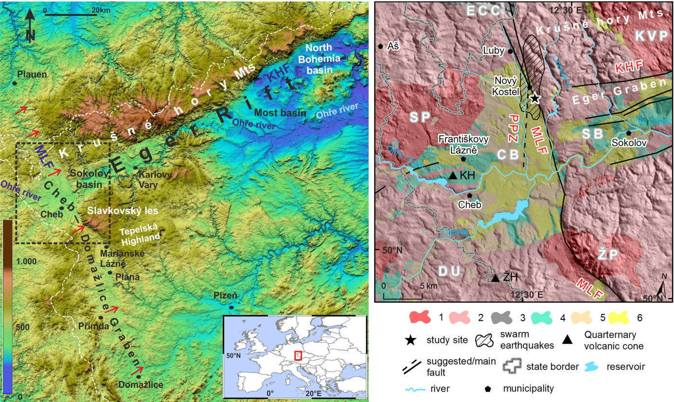
Fig. 1. Left panel: relief map from SRTM3 data with the main morphotectonic structures; red arrows – Mariánské Lázně fault (MLF), KHF – Krušné hory fault, dashed rectangle – extent of right panel. Right panel: geological map simplified after Babuška et al. (2010), Mlčoch (2003), Peterek et al. (2011), and Zulauf et al. (2002). Hatched area defines territory with the highest density of swarm epicentres 1997-2017. Geology: 1 – Late Variscan granites and granitoids; 2 – Variscan metamorphic units; 3 – Volcanics (mainly Oligo-/Miocene); 4 – Miocene (Cypris Formation); 5 – Plio-/Pleistocene (Vildštejn Formation); 6 – Quaternary. Saxothuringian: ECC – Erzgebirge (Krušnéhory) Crystalline Complex, DU – Dyleň Unit; Variscan granitoids: SP – Smrčiny (Fichtlgebirge) Pluton, KVP – Karlovy Vary Pluton, ŽP – Žandov Pluton; CHB – Cheb basin, SB – Sokolov Basin; KHF – Krušné hory Fault zone, MLF – Mariánské Lázně Fault zone, PPZ – Počátky-Plesná Fault zone. Quarternary volcanic cones: KH – Komorní Hůrka volcano, ŽH – Železná Hůrka volcano. After Štěpančíková et al. (2019).
The course of the fault is not properly geologically proved in the NW part between the CZE-GER state border and the Nový Kostel and it is traced only morphologically. However, the fault is crosscutting the bodies of phyllites in the NNW-SSE direction and their displacement suggests the dextral movement on this part of the fault (Müller et al., 1997). The sedimentary Cheb Basin is bounded by the MLF in the segment between Nový Kostel and Milíkov. The youngest gravels, sands and clays of Vildštejn formation (Pliocene-Pleistocene) or clays and claystones of an older Cypris formation (Miocene) can be found on the surface to the west of the fault. Holocene cover of various thickness (e.g. loess) can be found there as well (Teodoridis et al., 2016). Older formations - Staré Sedlo formation, Nové Sedlo formation (Eocene) or Sokolov formation (Oligocene-Miocene) are known only form wells and are not exposed on the surface (Müller et al., 1997). However, the Tertiary infill of the basin is in the sharp contrast with the schists and other crystalline rocks laying to the east of the MLF (Chlupáč et al., 2002). The part of the MLF between Milíkov and Mariánské Lázně is not forming any distinct lithological boundary. The fault is crosscutting mainly the granitic rocks or other crystalline rocks of saxo-thuringian unit (Cháb et al., 2008). Also, the fault orientation NW-SE in this part is different from the prevailing NNW-SSE direction. There is complicated lithological situation in the surroundings of Mariánské Lázně: the fault itself is forming the fault zone with diverse lithological blocks between fault branches. The orientation of MLF is changing to typical NNW-SSE direction to the south of Mariánské Lázně, also the fault is forming a boundary between granitic and metamorphic rocks of Teplá-Barrandian. MLF is formed by two or more parallel branches in this segment (Seifert a Straka, 1998). There are two main deviations from the prevailing orientation of the fault: the short segment near Kočov, where is the orientation almost W-E and the segment between Boječnice and Staré sedlo (NW-SE) (Seifert a Straka, 1998). To the south of Staré Sedlo, there is mostly only simple course of the fault (without branching) of NNW-SSE orientation. The fault is separating the Sedmihoří granitic massif from the major body of moldanubian batholite and further to the south it is crosscutting the paragneisses of moldanubian. In the part between granitic massifs, the MLF is accompanied with the zone of the weak hydrothermal alteration (Vejnar et al., 1980). According to faults parallel to the MLF, the main fault should have a steep dip to WSW Vejnar et al., 1978). The fault is gradually fading out south to the Horšovský Týn and it cannot be detected in lithology or morphology south to the Blížejov (Vejnar et al., 1978b).
Fault structure and dip
The MLF fault structure is complex and has been described by several authors differently, also depending on the various geological period of its activity (Špičáková et al. 2000, Peterek et al. 2011). Due to lack of the outcrops, the boreholes, geophysics and trenching survey that covers only very superficial part, are the only source of information. In a 100 m long trench across the most morphologically pronounced sections of the MLF near Kopanina village, the paleoseismic trenching survey revealed several fault strands with repeated movements and migrating activity towards the basin within a ~28 m-wide zone, which most probably form a single fault at the depth and which displaced Oligocene to Holocene sediments (Blecha et al. 2018, Štěpančíková et al. 2019)(Fig. 2). These faults appeared to dip towards the SW to the basin, usually 80°, which was also confirmed by the shallow geophysical survey (Fischer et al. 2012) as well as deeper geophysics (Blecha et al. 2018) (Fig. 2). Those geophysical surveys show the area of expected MLF position as an up to 100 m wide zone of low resistivity, low density and low seismic velocity, which could indicate a zone of intensively fractured and weathered rocks along the fault zone. The dip of the MLF was then shown as generally steeply dipping towards SW with dip 60° near the surface to 80° in the deeper parts. The normal dragging along the boundary fault of the MLF in the same area near Kopanina site was also confirmed by the seismic reflection by Halpaap et al. (2018).
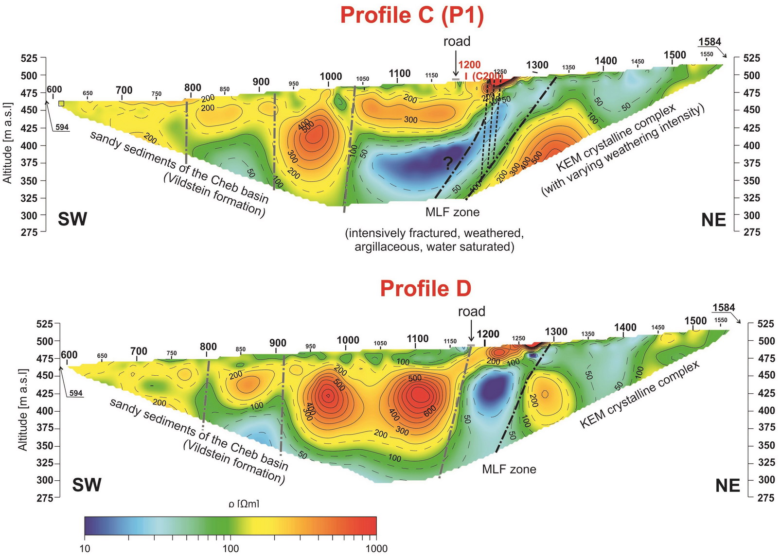
Fig. 2 Example of ressults of geophyiscal survey, namely electrical resistivity tomography (ERT) across the MLF near Kopanina site. Black dashed lines represent MLF zone, probably fractured and/or intensively weathered and water saturated as shown by higher conductivity. The dotted lines on profile C represent a splay of faults revealed by trenching and ERT by Fischer et al. (2012) and Štěpančíková et al. (2019). Adopted from Blecha et al. (2018).
Cross structures and Segmentation
The segmentation of the MLF was made for the purpose of the Fault database and further calculations, based on 1:50000 scale geological maps (CGS) and supplementary topographic data (DMR 4G; ČÚZK 2017). For the numerical purpose the strike changes of the fault trace were the leading information for segmentation (making sections), and 53 sections were distinguished.
Moreover, about 20 major cross structures were found along the MLF and were incorporated to the database with a proper code. Most of these structures are in the central and southern part of the MLF (to the south of Mariánské Lázně). Some of them are elongated step-overs of the main fault. The general direction of the MLF (besides 3 short parts, see above) is NNW-SSE. Therefore, the orientation of the cross structures is varying between WNW-ESE to SW-NE.
Large parts of the MLF are formed of two or more branches, only the parts between Milíkov and Kynžvart, and further to the south to Staré Sedlo, seem to be a simple course of the fault without branching.
Scarp morphology
The MLF is expressed in morphology by more or less pronounced fault scarp at the length of 120 km from Plauen in Germany to Horšovský Týn despite the lack of any fault outcrops (Fig. 1). In the northern part the fault is expressed by a linear arrangement of saddles and by 40-130 m high slope (fault scarp), which divides Smrčiny (Fichtelgebirge) from Krušné hory Mts (Erzgebirge) on the Czech territory. Around Nový Kostel, the fault splays into two scarps, where one is expressed by linear arrangement of places where enhanced headward erosion starts and several valleys change their character or direction, and the second by a steeper slope. This segment is proved also by geophysics and paleoseismic trenching (Fischer et al. 2012, Štěpančíková et al. 2018). From Milíkov the fault is bent and controls the highest elevated area, Slavkovský les by up to 300 m high fault scarp. The scarp is expressed by pronounced trapezoidal to triangular facets. From Mariánské Lázně the fault scarp strikes again NW to NNW and it steps over to the right near Planá, from where is rectilinear to Kočov, where the main river Mže antecedently flows into the fault scarp of about 100 m height. More to the south, almost up to Bor, the fault steps over to the left and is almost N-S striking expressed by two parallel gentle fault scarps, 10-15 m high. This segment seems to be morphologically the youngest one. Near Nová Hospoda (3 km north of Bor) Neogene fluvio-lacustrine sediments are ceased by the fault. From Bor to Staré Sedlo the fault/fault scarp is bending twice from N-S direction to WNW-ESE and reaches the height 15-35 m. From Horšovský Týn, the fault is not expressed in morphology any more.
Seismicity
To be revisited after completion of earthquake catalogue. 
The Cheb basin, which is controlled by the MLF at its eastern limit, is a part of one of the neotectonically most active regions in central Europe and overlaps with the West Bohemia/Vogtland earthquake swarm region that is characterized by persistent weak to moderate seismic activity (Fischer et al., 2014). The earthquake swarms are related mainly to the Nový Kostel focal zone, which dominates the seismicity of the whole West Bohemia/Vogtland area (Fig. 1, right panel). This is the location of all the ML≥3 swarms during the past 30 years (one swarm in 1985 and 6 others between 1997 and 2018). Recent earthquake swarms usually consist of several thousands of earthquakes with prevailing focal depths between 6 and 15 km. The NK focal zone is formed by a steeply dipping narrow NNW striking belt of about 12 km length and by several intersecting fault planes with prevailing N-S orientation, which are step-wise activated. It crosscuts the MLF, suggesting no relation of the present earthquake swarms with the MLF (Fischer et al., 2014).
Pre-Miocene evolution
The MLF originated already in the late-Variscan as a normal fault with a dextral component and which alternated several different kinematics (Pitra, 1999). The fault itself is a bounding structure of several distinctive geological units of the Bohemian Massif at the surface: the Saxo-Thuringian unit in the NW, Moldanubian unit in the S and SW and Teplá-Barrandian unit in the E (Zoubek et al. 1963). The MLF is parallel to the West Bohemian Shear Zone to the West (Zulauf et al. 2002) which separates the Teplá-Barrandian in the East from the Moldanubian in the West and probably roots in the lithospheric mantle (Babuška et al. 2007). According to Zoubek et al. (1963) the MLF originated probably during the Asturian phase of the Variscan orogeny. During pre-mesozoic period the vertical position of the blocks on the both sides of the MLF was opposite to the present-day one. This could have lasted probably still during the beginning of the Tertiary sedimentation in the basins when Cheb basin (western block) was at higher position than the adjacent Sokolov basin (eastern block) as it is suggested by the lack of the oldest formations of Sokolov basin in the Cheb basin.
Fault activity in late Cenozoic
Tertiary
The evolution of the MLF started to have its great importance later with the Late Cenozoic Eger rift formation. It has been studied and known only due to Cheb basin formation controlled by the northern section of the MLF. So, the MLF evolution is related to the Cheb basin evolution.
The stratigraphy in the Cheb basin can be simplified and divided into three intervals (Malkovský, 1995; Špičáková et al., 2000). The Pre-Cypris strata (Late Oligocene to Early Miocene, ca. 26-21 Ma) group together the Lower Clay and Sand Formation, including volcanics and volcanoclastics and the coal seam formation, which fill several small depocenters associated with E-W trending normal faults. The Cypris Formation (Early to Middle Miocene, ca. 21-17 Ma) is characterized by widespread lacustrine conditions with dominant clay lithologies. This depositional period was terminated by partial uplift and erosion. The Vildštejn Formation (Late Pliocene-Pleistocene, ca. 4.5-1.4 Ma; Teodoridis et al., 2017) was deposited discordantly after a hiatus of 12 Ma duration. Its fluvio-lacustrine sediments consist of kaolinic clays, sands and gravels. During this period the NW-trending faults controlled the shape of the basin depocenters, especially the MLF as a master fault. Špičáková et al. (2000) proposed that the MLF acted as a sinistral strike-slip fault under transtension, although they mentioned also some contradictions (see also Rojík et al., 2014). The asymmetric subsidence was accompanied or followed by the uplift of the footwall with the Krušné hory Mts., which resulted in separate evolution of the formerly united Cheb and Sokolov basins (Špičáková et al., 2000; Pešek et al., 2014).
Quaternary
The Quaternary activity of the fault can be inferred from the morphology of the fault scarp controlled by the MLF as well as from the boreholes in the Cheb basin and paleoseismic trenching survey.
Geomorphology
The fault scarp controlled by the MLF at the lenght of around 100 km is one of the most prominent fault scarp in the Bohemian massif with several antecedent valleys of the largest rivers in the region, with anomalies of longitudinal river profiles analysed by morphometric methods, rectangular drainage network, tectonic valley assymmetry etc. In the Cheb basin sections, rapid changes in erosion intensity are present in the MLF zone related to the uplift. While in the Krušné hory Mts. well-preserved and deep V-shaped valleys are present, in the Cheb Basin, valleys are shallow and U-shaped.
Quaternary tectonic activity of the MLF is evidenced also by offset of the fluvial terraces of the Ohře/Eger river in the Cheb basin. Newly published work shows their vertical offset within the longitudinal profiles when crossing the Mariánské Lázně fault, which limits the Cheb basin towards the Chlum horst (Balatka et al. 2019). The vertical offset of the oldest terraces, which are ascribed to the early Pleistocene in age, is 15-20 m, with diminishing offset in progressively younger terraces, so it shows that the MLF has been active through the entire Pleistocene (Fig. 3).
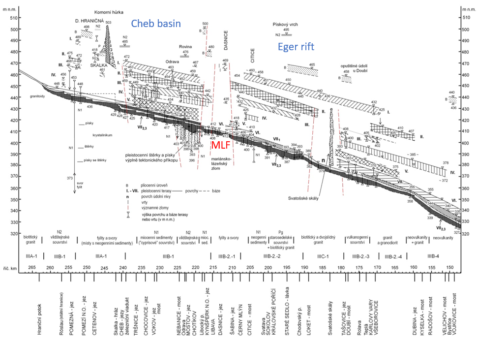
Fig. 3. A longitudinal profile of the Eger River terraces between the Smrčiny Mountains and the Doupovské hory Mountains. The red dotted lines – significant faults. The terraces of I., II., III. are uplifted along the MLF and can be found at higher position on the footwall than in the Cheb basin. Adopted from Balatka et al. (2019).
Continuity of overlying strata
The activity of the MLF during Quaternary has been documented based on Plio-Pleistocene Vildštejn Formation, whose depocenter with >100 m thickness is related to the MLF.
Oligocene to Holocene strata displaced by several strands of the MLF zone were documented in the paleoseismic trenches in the Cheb basin close to the Kopanina village (Štěpančíková et al. 2019). The topsoil was the only layer that was demonstrably non deformed, while the underlaying Holocene units of the age 4-1 ka have been displaced twice (Fig. 4).
Seismicity and paleoseismicity
Historical records show several earthquakes that could be associated with the southern continuation of the MLF within the Cheb Domažlice graben. These are the earthquakes in 1688 near Domažlice, in 1787, 1788, 1855 and in 1915 near Planá, and 1902 near Přimda (Procházková and Šimůnek, 1999; Leydecker, 2011) with intensity I0 from 4.5° to 6.5° MSK. The unknown focal mechanisms of these pre-instrumental earthquakes, however, prevent us from verifying their tectonic relation to the MLF.
The paleoseismic studies at the Kopanina site, close to Nový Kostel village, revealed that the MLF was reactivated during several ground-breaking earthquakes during late Quaternary, with mid-Pleistocene normal faulting and two M6.5+ events in the late Holocene of right-lateral strike-slip character under transpression with maximum vertical displacement of 0.4 m (Štěpančíková et al. 2017, 2019). The youngest event dated by radiocarbon dating into the interval of about 792 to 1020 AD, which is even the historical event (Fig. 4). The fast seismic character of the movements documented in the trenches is indicated by the fault scarp, folds, push-up, and fissures, by faulted and folded strata, as well as by microstructural analysis of grain samples taken from the fault zone and showing different orientations of the grains within the fault and outside.
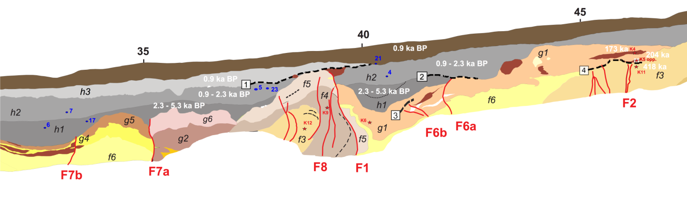
Fig. 4. Simplified chronological scheme of the faulting revealed in the Kopanina A trench. Calibrated radiocarbon (dots for samples) and OSL ages (asterisks for samples) of the strata in the area of the faults F1, F2, F6, F7, and F8 are indicated in white; dash bold lines mark the event horizons of the events 1, 2, 3 and 4. Adopted from Štěpančíková et al. (2019).
Based on the empirical relationships between moment magnitude, rupture length and surface displacement described by Wells and Coppersmith (1994), the extensively used magnitude scaling relationships in paleoseismology, a probable minimum earthquake magnitude for the recorded events on the MLF were approached. The surface rupture length was consider to be at least 10 km, identified by using LiDAR images and vertical fault displacements, which points to a minimum moment magnitude up to Mw=6.3 to 6.5. The values of Mw based on displacements were similar ranging from Mw=6.1 to 6.6 (Štěpančíková et al. 2019).
Related local evidence
(See layer Local evidence on a map. The sites are listed in south-to-north order.)
The local evidence of the activity of the MLF was documented in the paleoseismic trenches at the Kopanina site, close to Nový Kostel village, by deformed and displaced Oligocene to Holocene stratigraphy (Fig. 5)(Štěpančíková et al. 2017, 2019).
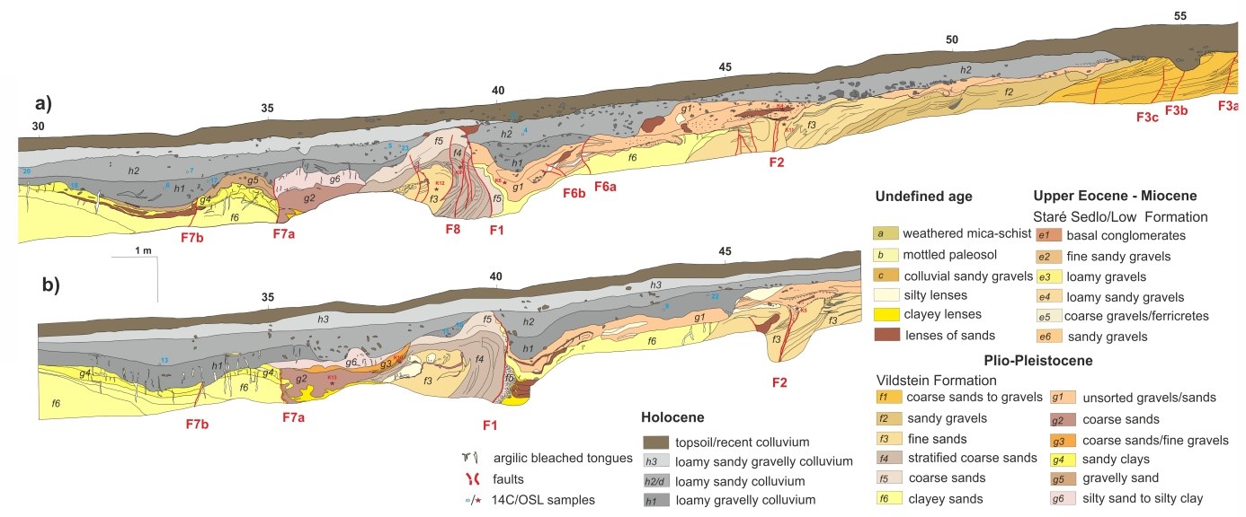
Fig. 5. Paleoseismological log of the Kopanina A trench with geological information. a) – southern part of the log of SE-facing wall, b) - flipped NW-facing wall. Adopted from Štěpančíková et al. (2019).
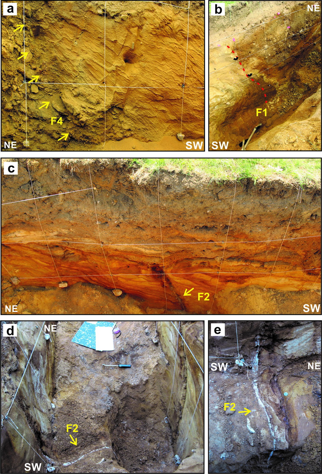
Fig. 6. Photographs from the trench Kopanina A, see the 0.5 m grid on the walls for scale. (a) Deformation bands around fault F4, NW-facing wall, X=58 m at the log – fig. 5 (b) Fault F1 with folded sandy layers (left block) and downwarped beige clay, sand and Holocene loamy colluvium (right block) sealed by upper 0.5 m of topsoil and unit h3, black marks – matching points, SE-facing wall, X=39-41 m, © Fault F2 with normal drag of unit f3 sandy layers (left block) pigmented by iron oxyde-hydroxides, NW-facing wall, X=44-46 m, (d) Fault F2 filled with white silty clay and (e) accompanied by distinctive iron mineralization that hardened the fault zone and by structures reminding Riedel shears on the trench floor indicating a horizontal component. Adopted from Štěpančíková et al. (2019).
Main data sources for fault map
- Geologická mapa. List 11-41 Mariánské Lázně. Český geologický ústav
- Seifert A., Straka, J., 1998. Geologická mapa 1: 50 000, list 11-43 Bor. ČGS, Praha.
- Vejnar, Z., Šalanský, K., Skrbek, J., 1978. Vysvětlivky k základní geologické mapě ČSSR 1:25 000, list 21-214 Mířkov. Ústřední ústav geologický, Praha
- Vejnar, Z., Šalanský, K., Skrbek, J., 1978b. Vysvětlivky k základní geologické mapě ČSSR 1:25 000, list 21-232 Horšovský Týn. Ústřední ústav geologický, Praha
- Vejnar, Z., Šalanský, K., Skrbek, J., 1980. Vysvětlivky k základní geologické mapě ČSSR 1:25 000, list 21-212 Staré Sedlo. Ústřední ústav geologický, Praha
Other notes
…
References
- Adamová, M., Čurda, J., Lochmann, Z., Majer, V., Müller, V., Opletal, M., Pošmourný, K., Tomášek, M., Veselý, J., Volšan, V., 2001. Soubor geologických a ekologických účelových map přírodních zdrojů 1:50 000, Geologická mapa. List 11-41 Mariánské Lázně. Český geologický ústav.
- Balatka B., Kalvoda J., Steklá T., Štěpančíková P. (2019): Morphostratigraphy of river terraces in the Eger valley (Czechia) focused on the Smrčiny Mountains, the Chebská pánev Basin and the Sokolovská pánev Basin. AUC GEOGRAPHICA, Vol 54 No 2 (2019), 240–259.
- Blecha V., Fischer T., Tábořík P., Vilhem J., Klanica R., Valenta J., Štěpančíková P. (2018): Geophysical evidence of the Eastern Marginal fault of the Cheb Basin (Czech Republic). Studia Geophysica et Geodaetica, Volume 62, Issue 4, pp 660–680, DOI 10.1007/s11200-017-0452-9.
- Blížkovský, M., Čejchanová, B., Friáková, O., Hanák, J., Kadlec, E., Mitrenga, P., Novák, M., Novotný, A., Ondra, P., Švancara, J., 1981. Construction of the stripped gravity map of the Bohemian Massif on the basis of revision of density data, Part II. Density data on the Bohemian Massif on the territory of ČSR. Geofyzika n.p. Brno, unpublished internal report (in Czech).
- DEMEK J., CZUDEK T.,(1957) : Geomorfologické poměry Jilmového potoka na Tepelské vrchovině, Sborník ČSSZ, číslo 3, svazek 62, 193–205.
- Fischer, T., Horálek, J., Hrubcová, P., Vavryčuk, V., Bräuer, K., Kämpf, H., 2014. Intra-continental earthquake swarms in West-Bohemia and Vogtland: a review, Tectonophysics 611, 1-27, doi: 10.1016/j.tecto.2013.11.001
- Fischer, T., Štěpančíková, P., Karousová, M., Tábořík, P., Flechsig, Ch. and Gaballah, M. (2012): Imaging the Mariánské Lázně Fault (Czech Republic) by 3-D ground-penetrating radar and electric resistivity tomography. Studia Geophysica et Geodaetica 56 (2012), p. 1019-1036, DOI: 10.1007/s11200-012-0825-z.
- Flechsig, C., Fabig, T., Rücker, C., Schütze, C., 2010. Geoelectrical investigations in the Cheb Basin/W-Bohemia: an approach to evaluate the near-surface conductivity structure. Stud. Geophys. Geod. 54, 443–463.
- Halpaap, F., Paschke, M., Bleibinhaus, F., 2017: Shallow Reflection Seismic Evidence of Tectonic Activity in the Cheb Basin, NW Bohemia, Studia Geophysica et Geodaetica, doi: 10.1007/s11200-016-0386-7
- Cháb, J., Breiter, K., Fatka, O., Hladil, J., Kalvoda, J., Šimůnek, Z., Štorch, P., Vašíček, Z., Zajíc, J., Zapletal, J., 2008. Stručná geologie základu Českého masivu a jeho karbonského a permského pokryvu. Vydavatelství ČGS, Praha, 283 p.
- Chlupáč, I., Brzobohatý, R., Kovanda, J., Stráník, Z., 2002. Geologická minulost České republiky. Academia Praha, Praha, 436 p.
- Květ R., Ivan A., (1983): Fotolineamenty v oblasti tachovsko - domažlického příkopu, Sborník ČSGS, svazek 80, 256–259.
- Malkovský, M., 1987. The Mesozoic and Tertiary basins of the Bohemian Massif and their evolution. Tectonophysics 137, 31–42.
- Mlčoch B. and Skácelová Z., 2009. Digital elevation model of the crystalline basement of the Cheb and Sokolov Basin areas (Western Bohemia, Central Europe). Z. Geol. Wiss., 37, p. 145-152.
- Müller, V., Burda, J., Dubec, O., Hrazdíra, P., Hrkal, Z., Jinochová, J., Lochmann, Z., Majer, V., Manová, M., Mlčoch, B., Rejchrt, M., Sáňka, V., Schovánek, P., Skácelová, D., Šalanský, K., Šantrůček, P. (1998). Vysvětlivky k souboru geologických a ekologických účelových map přírodních zdrojů v měřítku 1 : 50 000. Listy 11 - 13 Hazlov, 11 - 14 Cheb. Český geologický ústav. ISBN 80-7075-263-7
- Neunhöfer, H., Hemmann, A., 2005. Earthquake swarms in the Vogtland/Western Bohemia region: Spatial distribution and magnitude-frequency distribution as an indication of the genesis of swarms? J. Geodynamics 39, 361-385.
- Pešek, J., 1972. Terciérní sedimenty ve středních a západních Čechách. Sborník Západočeského muzea Příroda, 6, 56 pp.
- Pešek, J. ed. 2014. Tertiary basins and lignite deposits of the Czech Republic. Czech Geological Survey, 283p.
- Procházková D., Šimůnek P. (1999): Regional earthquake catalogue and focal regions in central Europe, Acta Montana IRSM AS ČR, Series A Geodynamics, No. 13 (111), Praha, 83p.
- Rojík, P., Fejfar, O., Dašková,J.,Kvaček, Z., Pešek, J., Sýkorová, I., Teodoridis, V. 2014. Cheb basin. In: Pešek, J. ed. Tertiary basins and lignite deposits of the Czech Republic. Czech Geological Survey, 143-161.
- Seifert A., Straka, J., 1998. Geologická mapa 1: 50 000, list 11-43 Bor. ČGS, Praha.
- Špičáková, L, Uličný, D, Koudelková, G, 2000. Tectonosedimentary evolution of the Cheb Basin (NW Bohemia, Czech Republic) between Late Oligocene and Pliocene: a preliminary note. Studia Geoph. Geod 44: 556–580.
- Štěpančíková, P., Tábořík, P., Fischer, T., Hartvich, F., Karousová, M., Stemberk, J. (Jr.), Nováková, L., 2015: Holocene activity of the Mariánské Lázně Fault (Cheb basin, Bohemian Massif): youngest proved surface faulting in central Europe? In: Blumetti, A.M., et al. (Eds.), 6th International INQUA Meeting on Paleoseismology, Active Tectonics and Archaeoseismology, 19-24 April 2015, Pescina, Fucino Basin, Italy, Miscellanea INGV, 27, pp. 490-492.
- Teodoridis, V. , Bruch, A.A., Martinetto, E., Vassio, E., Kvaček, Z., Stuchlik, L. ,2017. Plio-Pleistocene floras of the Vildštejn Formation in the Cheb Basin, Czech Republic – a review and a new paleoenvironmental evaluation – Palaeogeography, Palaeoclimatology, Palaeoecology, 467 (2017): 166-190.
- Vejnar, Z., Šalanský, K., Skrbek, J., 1978. Vysvětlivky k základní geologické mapě ČSSR 1:25 000, list 21-214 Mířkov. Ústřední ústav geologický, Praha
- Vejnar, Z., Šalanský, K., Skrbek, J., 1978b. Vysvětlivky k základní geologické mapě ČSSR 1:25 000, list 21-232 Horšovský Týn. Ústřední ústav geologický, Praha
- Vejnar, Z., Šalanský, K., Skrbek, J., 1980. Vysvětlivky k základní geologické mapě ČSSR 1:25 000, list 21-212 Staré Sedlo. Ústřední ústav geologický, Praha
- Wells, D.L., and Coppersmith, K.J., 1994. New empirical relationships among magnitude, rupture length, rupture width, rupture area, and surface displacement. Bulletin of Seismological Society of America, 84, 974–1002,
- Zoubek V. (ed., 1963): Vysvětlivky k přehledné geologické mapě ČSSR 1 : 200 000, list M-33-XIII, Karlovy Vary - Plauen. NČSAV Praha
- Zulauf, G., Buess, C., Dörr, W., Vejnar, Z. 2002. 10 km Minimum throw along the West Bohemian shear zone: Evidence for dramatic crustal thickening and high topography in the Bohemian Massif (European Variscides). Int J Earth Sci 91: 850–864
mlz/marianske_lazne_fault.txt · Last modified: 2020/05/22 16:20 by petrs
Except where otherwise noted, content on this wiki is licensed under the following license: CC Attribution-Share Alike 4.0 International
