Table of Contents
Pfahl Fault System (PFFS)
Structure ID: PFHQ / PFH
Fault Section IDs: PFHQ_01 – PFHQ_22 / PFH_01 – PFH_04
Related terms: Pfahl, bavorský křemenný val (in Czech); Pfahl-Störungssystem (De); Bavarian Pfahl shear zone (En)
Editor: Ivan Prachař
Last update: 6. 12. 2022
General description
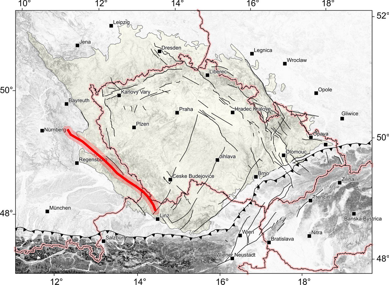
The Pfahl is NW-SE striking, steep to NE dipping fault system which runs from Schwarzenfeld in Oberpfälz Forest, through the Bavarian Forest (D), along the border with the Czech Republic, to Klafferstraß (D) on the German-Austrian border and then runs via Ulrichsberg, through the Mühl river valley to Haslach an der Mühl and further to Untergeng in the Große Rodl valley, where it is cut off from the Rodl fault system (see also http://resource.geolba.ac.at/ structure/147). The German word ‘‘Pfahl’’ makes reference to the quartz lode running through the Bavarian Forest in the length of 150 km (see all Fsections PFHQ).
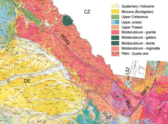
This fault system is evident in the Moldanubian complex (see Fig. 1), mainly due to the distinctive quartz lode, along which there are a number of smaller granitoid massifs of the Weinsberg and Eisgarn type.
Fig. 1: Sketch of the Pfahl fault system (PFHQ – quartz vein and PFH section) depicted on the raster geological map of Bavaria (1: 500 000) and Upper Austria (1: 200 000).
It is assumed that the fault zone continues to the Franconian Jura in the form of direction-related faults (see Geological map of Bavaria 1 : 500 000). E.g. as parallel Amberg-Sulzbach fault (NW-SE) or Freihunger fault (see REYNHOLD, 2005). A fault that is parallel to Pfahl limits the half-graben “Bodenwöhrer Senke” between Pösing and Schwarzenfeld, where Permo-carboniferous and Upper Cretaceous sediments are deposited (see upper left corner of Fig. 1).
Fault structure and dip
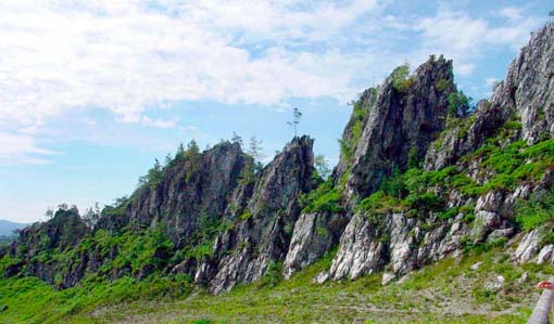
In the Bavarian Forest, the fault acts as a Pfahl quartz lode 150 km long. Over long distances, this quartz wall rises up to approximately 30 meters above the surroundings thanks to weathering resistance (see Fig. 2). The lode width is around 120 m. Dip of the lode is steep to the NE.
Fig. 2: The „Große Pfahl“ near Viechtach (D). Photo Bavarian Forest Nature Park. (https://www.arberland-bayerischer-wald.de/pfahl-významný-přírodní-památník/150/5631/21516).
The vein consists of 95-98% quartz (see MESCHEDE, 2015). The formation of a vein is explained as a long-lasting hydrothermal process where cyclic dissolution, precipitation and fragmentation of quartz occurred on large scale (see YILMAZ ET AL., 2014).
The mylonites are also present in the Pfahl Zone. They are strongly overprinted by subsequent brittle deformation. As one of the major dextral shear zones the foliation dips steeply to the NE with a sub-horizontal stretching lineation. On a macroscopic and a microscopic scale, the mylonites are developed as highly deformed rocks comprising a fine-grained matrix flowing around large feldspar clasts. Quartz most commonly occurs as recrystallized grains forming bands (see BRANDMAYR ET AL., 1997).
Cross structures and Segmentation
More significant segmentation of the Pfahl can be observed near Haslach an der Mühl, where a distinct quartz vein is terminated. Here it is also possible to observe topo-lineaments of the NNE-SSW direction, which follow the faults of the Lhenice shear zone in the north. The course of the Pfahl fault system also turns gradually from NW-SE to NNW-SSE. Between Haslach and crossing with the Rodl fault, the Pfahl fault system is not accompanied by a quartz lode (see Raster geological map of Upper Austria 1 : 200 000).
Scarp morphology
The morphological manifestation of the Pfahl fault zone between Schwarzenfeld and Haslach an der Mühl is highlighted by a quartz wall rising up to 30 m (see Fig. 2).
Seismicity
To be revisited after completion of earthquake catalogue. 
Pre-Miocene evolution
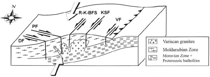
The beginning of Pfahl shear zone formation is dated to the Early Paleozoic in connection with the formation of the Moldanubian nappes as a result of large-scale northeastward directed transpression of an Early Paleozoic terrane. After this main tectonic event, shear activity initiated on the dextral shear zone set of the Pfahl and Danube Shear Zones and in the sinistral Rodl / Karlstift / Vitis Shear Zones (see BRANDMAYR ET AL., 1997), as shown in Fig. 3.
Fig. 2: Initial shear zone activity in the Danube (DF), Pfahl (PF), Rodl (RF), Karlstift (KSF) and Vitis (VF) Shear Zones. Arrows indicate major compression directions. Adopted from BRANDMAYR ET AL. (1997).
However, the main ductile deformation phase is dated to the Late Variscian, showing mainly dextral direction of movement (see http://resource.geolba.ac.at/structure/147). This corresponds to the age of syn-kinematic mylonites (so-called palites - feldspar-phyric massive rock) and other dykes, which was determined by SIEBEL ET AL. (2005) at 332.7-334.5 Ma (Lower Carboniferous). The authors further state that the shear zone controlled the siting of these intrusions and that the shear zone was active when the magmas intruded. Dating also showed a long-lasting cooling history after mylonitization.
Fault activity in late Cenozoic
Tertiary
It is considered that during Miocene a brittle reactivation with the same kinematics went on. (see BRANDMAYR ET AL., 1997; BÜTTNER, 2007). Post Miocene activity of the Pfahl fault zone has not been proven, yet.
Quaternary
There is no evidence that this fault system was active in the Quaternary.
Related local evidence
(See layer Local evidence on a map. The sites are listed in south-to-north order.)
They are not yet processed. …
…
Main data sources for fault map
See text above.
Other notes
…
References
- BRANDMAYR, M., LOIZENBAUER, J. & WALLBRECHER, E., 1997. Contrasting P-T conditions during conjugate shear zone development in the Southern Bohemian Massif, Austria.- Mitteilungen der Österreichischen Geologischen Gesellschaft 90, p. 11-29.
- BÜTTNER, S.H., 2007. Late Variscan stress-field rotation initiating escape tectonics in the south-western Bohemian Massif: A far field response to late-orogenic extension.- In: Journal of Geosciences 52, Nr. 1-2, S. 29-43.
- MESCHEDE, M., 2015. Geologie Deutschlands: Ein prozessorientierter Ansatz. 249 s., Český Springer-Verlag, 2018. [in German]
- REYNHOLD, K., 2005. Tiefenlage der Kristallin – Oberfläche in Deutschland. Abschlussbericht, 89 s., BGR, Hannover/Berlin.
- SIEBEL, W.; BLAHA, U.; CHEN, F.; ROHRMÜLLER, J., 2005. Geochronology and geochemistry of a dyke-host rock association and implications for the formation of the Bavarian Pfahl shear zone, Bohemian Massif. International Journal of Earth Sciences (Geologische Rundschau) 94, Nr. 1, S. 8-23.
- YILMAZ, T. I.; PROSSER, G.; LIOTTA, D., KRUHL, J.H. ; GILG, H.A., 2014. Repeated hydrothermal quartz crystallization and cataclasis in the Bavarian Pfahl shear zone (Germany). Journal of Structural Geology 68 (2014), 158-174.
- http://resource.geolba.ac.at/structure/147 (state to 2020-03-01).


