Table of Contents
Hronov-Poříčí Fault
Structure ID: HPF
Fault Section IDs:
Related terms: (cze: )
Editor: Miroslav Coubal, Petra Štěpančíková
Last update: 25. 6. 2020

← click the image to open new tab with interactive map
General description
The Hronov-Poříčí Fault has an orientation of NW-SE between Žacléř and Hronov (Malkovský 1977, Tásler ed. 1979) (Fig. 1). It changes it´s orientation to WNW-ESE near Hronov and continues to Poland, where are the fault structures called as Žďarky-Pstrążna structure (Wojewoda, J., 2009a). The continuation of the fault towards NW from Žacléř is not clear and provable in the rocks of Krkonoše - Jizera crystalline complex. The fault itself forms a boundary between Intra-Sudetic and Krkonoše-Piedmont basins of Permo-Carboniferous origin (Tásler et al. 1979). Also, it bounds upper Cretaceous Police basin from SW (Malkovský 1979).
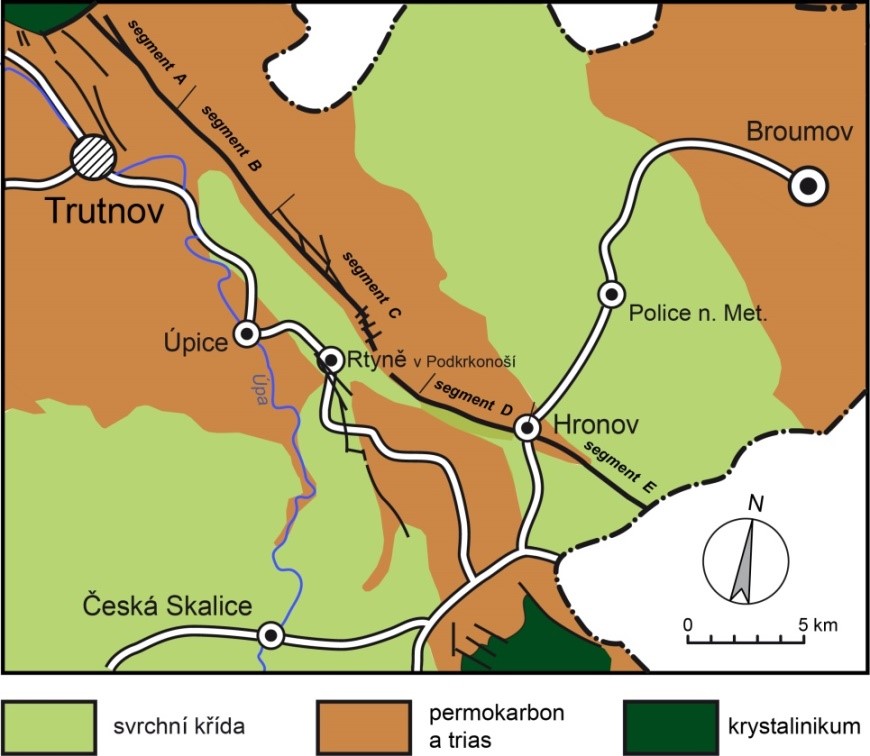
Fig. 1. Geological sketchof the Hronov-Poříčí fault with the main segments.
The Hronov-Poříčí Fault has an orientation of NW-SE between Žacléř and Hronov (Malkovský 1977, Tásler ed. 1979) (Fig. 1). It changes it´s orientation to WNW-ESE near Hronov and continues to Poland, where are the fault structures called as Žďarky-Pstrążna structure (Wojewoda, J., 2009a). The continuation of the fault towards NW from Žacléř is not clear and provable in the rocks of Krkonoše - Jizera crystalline complex. The fault itself forms a boundary between Intra-Sudetic and Krkonoše-Piedmont basins of Permo-Carboniferous origin (Tásler et al. 1979). Also, it bounds upper Cretaceous Police basin from SW (Malkovský 1979).
The fault s.s. has an orientation of NW-SE, its main plane is dipping steeply to the NE and works as a reverse fault. There are outcrops of Carboniferous rocks of Žacléř and Odolov formations in the tectonic elevation to the NW side from the fault. In some places, there are also the outcrops of underlying Krkonoše-Jizera crystalline rocks. There are mostly Permian or partially Carboniferous rocks in the tectonic depression on the other side of the fault. There are thrusting of Carboniferous rocks over Cretaceous in the surroundings of Hronov.
Most of its course, the fault s.s. has the characteristics of a fault zone. The main fault is following by several parallel ones in the distance up to 250 m. Towards the SE, the accompanying faults are going closer to the main one and we can describe the structure as a simple fault in the part to the SE from Strážkovice. The fault plain is dipping to the NE – there is a dip 60-70° in the surroundings of Svatoňovice, 70-80° near Žacléř and Hronov.
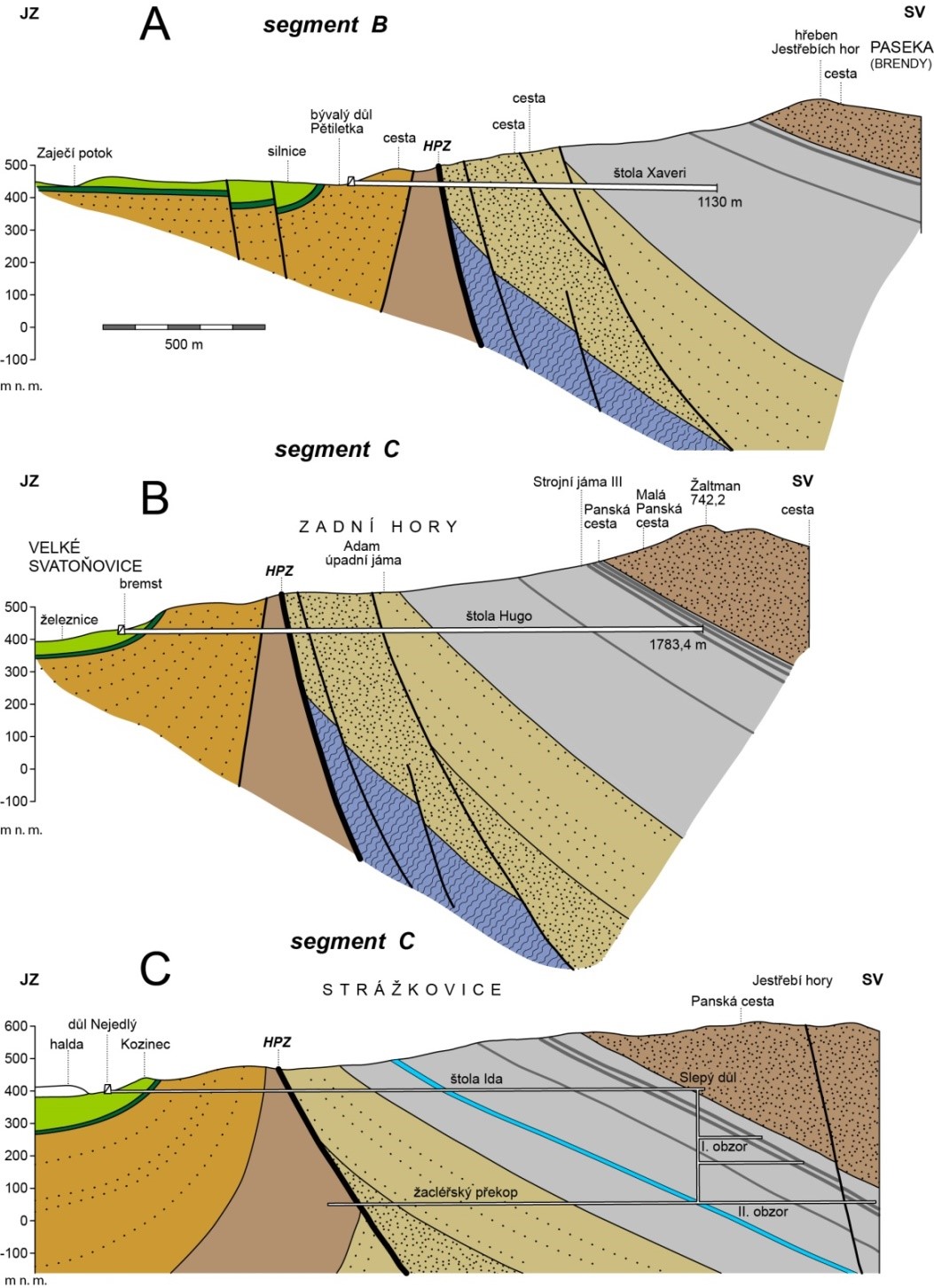
Fig. 2. Representative geological profiles across Hronov-Poříčí fault following the galleries Xaveri (A), Hugo (B) a Ida (C), nonexaggerated
The core of the main fault is separating the Carboniferous sedimentary rocks in the NE block from younger Permian and Cretaceous sediments in the SW block (Fig. 2). It is several meters wide at maximum and it is formed by breccia, blocks of different sizes or partially grey clay with crushed rocks.
The zone of the deformation along the fault can be separated into inner and outer part. The inner part is several hundred meters wide, it becomes narrower near Odolov and it is only tens meters wide in the surroundings of Hronov. The rocks there is (with variable intensity) crushed, mylonitized, slided or transformed to tectonic breccia. Sometimes, they can be mineralised (CaCO3, SiO2). The outer part can be delineated by the presence of slickensides and joints. It is width can be up to 1 km.
The movement range along the Hronov-Poříčí fault is not clear yet. Malkovský (1977) theorizes about 1000m range.
Fault structure and dip
The architecture of a wide zone of the Hronov-Poříčí fault (s.l.) is rather untypical due to “roof-shaped” laying of sediments in the neighbourhood of the main fault. Traditionally, this structure was interpreted as the regional scale fold, subsequently breached and deformed by Hronov-Poříčí fault, which is going through the fold along the inflection axis between anticline and syncline (Tásler ed. 1964, 1979, Malkovský 1977). Therefore the origin of the structure is interpreted as a result of two different subsequent processes. The other theory suggests the origin of the structure during one process: forming the anticline and syncline by the layer dragging during thrusting on the fault (Prouza, Coubal a Adamovič 2015). The basic structures of the fault (s.l.) are rather simple and similar along the fault. There are not many signs of poly-phases evolution of the fault, e.g. distinctive crosscutting faults. Comparing to other faults in the region of northern Bohemia, the structures of the Hronov-Poříčí fault are corresponding to the structures of compression α1 of upper Cretaceous-lower Paleogene origin. There are not enough preserved Cenozoic sediments in the area for detailed dating of fault origin. However, some authors suggest poly-phase evolution of the Hronov-Poříčí fault s.l. : Nováková (2014) and Wojewoda (2009 b, c). Wojweoda suggests the deformation phases: 1) Paleogene drop of the NE block, 2) Neogene drop of the SW block, 3) forming of the Hronov-Poříčí graben during recent period. Tectonic evolution of the Polish part of the fault he explains by the dextral strike-slip fault rejuvenation during the Tertiary-recent period.
Cross structures and Segmentation
The Hronov-Poříčí fault can be divided to 5 main fault segments, according to different structure and origin: a) žacléřský, b) markoušovický, c) rtyňsko-svatoňovický, d) zbečnický, e) žďárecký.
a) žacléřský – orientation NW-SE, dip 70-80°,dip direction: NE
b) markoušovický – orientation NW-SE, dip almost subvertical
c) rtyňsko-svatoňovický – orientation NW-SE, dip 60-70°, in the depth around 600 m dip around 40°
d) zbečnický – thrusting of Carboniferous rocks over Cretaceous, rise of the mineralised water on the crossing of Hronov-Poříčí fault and dislocations of N-S orientation.
e) žďárecký – orientation W-E, continues as Žďarky-Pstrążna structure (fault zone) in Poland
Scarp morphology
Seismicity
To be revisited after completion of earthquake catalogue. 
Pre-Miocene evolution
Fault activity in late Cenozoic
Tertiary
Quaternary
Related local evidence
(See layer Local evidence on a map. The sites are listed in south-to-north order.)
Main data sources for fault map
Other notes
…
References
- Braathen A., Tveranger J., Fossen H., Skar T., Cardozo N., Semshaug S. E., Bastesen E., Sverdrup E. (2009) Fault facies and its application to sandstone reservoirs. AAPG Bulletin 93: 891–917.
- Coubal, M., Adamovič, J., Málek, J., & Prouza, V. (2014): Architecture of thrust faults with alongstrike variations in fault-plane dip: anatomy of the Lusatian Fault, Bohemian Massif. – J. Geosci., 59, 183–208.
- Coubal, M., Málek, J., Adamovič, J., Štěpančíková, P. (2015): Late Cretaceous and Cenozoic dynamics of the Bohemian Massif inferred from the paleostress history of the Lusatian Fault Belt. J. Geodyn. 87, 1, 26-49.
- Engelder, T., Marshak, S. (1985): Disjunctive cleavage formed at shallow depths in sedimentary rocks. J. Struct. Geol. 7, 327–342.
- Fossen H. (2010): Structural Geology. Cambridge University Press, New York, pp 1–463.
- Grasemann, B., Martel, S., Passchier, C., 2005. Reverse and normal drag along a fault. Journal of Structural Geology 27, 999–1010.
- Havíř J., Pazdírková J., Sýkorová Z., Špaček P. (2006): Exhibitions of the seismo-tectonic activity in the NE part of the Bohemian Massif in the period 2004-2005. Geol. Res. Moravia Silesia (Geol. vyzk. Mor. Slez. v r. 2005), 13, 120121 (in Czech, with English Abstract).
- Kolínský P., Valenta J., Gaždová R. (2012): Seismicity, groundwater level variations and earth tides in the Hronov-Poříčí Fault Zone, Czech Republic. Acta Geodyn. Geomater., 9 (2), 191-209.
- Malkovský, M. (1977). Důležité zlomy platformního pokryvu severní části Českého masívu. Ústřední ústav geologický. Praha. 30pp.
- Malkovský, M. (1979): Tektogeneze platformního pokryvu Českého masivu (Tectogeny of the platform cover of the Bohemian Massif). Ústřední ústav geologický, Praha. 176 pp.
- Málek J., Brož M., Stejskal V., Štrunc J. (2008): Local seismicity at the Hronov-Poříčí Fault (Eastern Bohemia). Acta Geodyn. Geomater., 5(2), 171-175.
- Nováková, L. (2014): Evolution of paleostress fields and brittle deformation in Hronov-Poříčí Fault Zone, Bohemian Massif. Studia geophysica et geodaetica. 58: 269-288.
- Passchier, C. W. (2001) Flanking structures. J Struct Geol 23: 951–962.
- Petrascheck, W. (1904): Das Bruchgebiet des böhmischen Anteils der Mittelsudeten westlich des Neissegrabens. Zeitschrift Deutschen geologischen Gesellschaft, Bd.56, 210–222.
- Petrascheck, W. (1922): Zur Entstehungsgeschichte der sudetischen Karbon- und Rotliegendablagerungen. Zeitschrift Deutschen Geologischen Gesellschaft, (ed.1923), Bd. 74, 244–262.
- Petrascheck, W. (1933): Der böhmische Anteil der Mittelsudeten und sein Vorland. Mitteilungen Geologischen Gesellschaft, Bd. 26, 9–136.
- Prouza, V., Coubal, M., Adamovič, J. (2015): Specifika architektury hronovsko-poříčského zlomu. (Specific architecture of the Hronov-Poříčí Fault.) Zprávy o geologických výzkumech. Roč. 2014, č. 1 (2015), 13-18.
- Stejskal V., Štěpančíková P., Vilímek V. (2006): Selected geomorphological methods assessing neotectonic evolution of the seismoactive Hronov-Poříčí Fault Zone. Geomorph. Slovaca, 6, 14-22.
- Stejskal V., Skalský L., Kašpárek L. (2007): Results of two years’ seismo-hydrological monitoring in the area of the Hronov-Poříčí Fault Zone, Western Sudetes. Acta Geodyn. Geomater., 4(4), 59-76.
- Stejskal V., Kašpárek L., Kopylova G.N., Lyubyshin A.A., Skalský L. (2009): Precursory groundwater level changes in the period of activation of the weak intraplate seismic activity on the NE margin of the Bohemian Massif (Central Europe) in 2005. Stud. Geophys. Geod., 53, 215238.
- Špaček P., Sýkorová Z., Pazdírková J., Švancara J. and Havíř J. (2006): Present-day seismicity of the south-eastern Elbe Fault System (NE Bohemian Massif). Stud. Geophys. Geod., 50, 233-258.
- Tásler R. (1964): Permian-Carboniferous and Lower Triassic of the Intrasudetic Depression. In: Svoboda J. (Ed.), Regionální geologie ČSSR (Regional Geology of Czechoslovakia). Academia (CSAV Publishing), Prague, p. 204-232.
- Tásler, R., ed. (1979): Geologie české části vnitrosudetské pánve. – Ústřední ústav geologický, 296 s. Praha.
- Valenta J., Stejskal V., Štěpančíková P. (2008): Tectonic pattern of the Hronov-Poříčí Trough as seen from pole-dipole geoelectrical measurements. Acta Geodyn. Geomater., 5 (2), 185-195.
- Weithofer, K.A. (1897): Der Schatzlar-Schwadowitzer Muldenflügel des Niederschlesisch-Böhmischen Steinkohlenbeckens. – Jb. K.-kön. geol. Reichsanstalt, 47: 455-478. Wien.
- Wojewoda, J. (2007): Neotectonic aspect of the Intrasudetic Shear Zone. Acta Geodyn. Geomater., 4, 4 (148), 1–11.
- Wojewoda, J. (2009a): Žďarky-Pstrążna Dome: a strike-slip fault-related structure at the eastern termination of the Poříčí-Hronov Fault Zone (Sudetes). Acta Geodynamica et Geomaterialia 6: 273-290.
- Wojewoda, J. (2009b): The role of the Porici-Hronov Fault Zone in formation of sudetic basins (poster). Conference: 7th Meeting of the Central European Tectonic Studies Group (CETeG), Pecs, 13-16.05.2009.
- Wojewoda, J. (2009c): The role of the Porici-Hronov Fault Zone in formation of sudetic basins (konference paper). Conference: 7th Meeting of the Central European Tectonic Studies Group (CETeG), Pecs, 13-16.05.2009.
- Woodcock N. H., Mort K. (2008): Classification of fault breccias and related fault rocks. Geol Mag 145: 435–400.