Table of Contents
Hluboká Fault (HLU)
Structure ID: HLU
Fault Section IDs: HLU_01 to HLU_08
Related terms: hlubocký zlom; Reiningerův zlom (in Czech)
Editors: Ivan Prachař Petr Špaček
Last update: 22. 5. 2020
General description
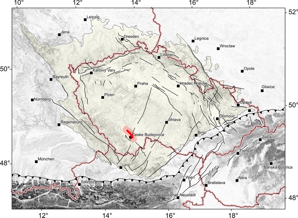
The Hluboká fault represents one of the very significant fault structures of the South Bohemian region. It is a system of faults in the NW - SE direction in general along the northeast edge of the Budějovice Basin. In a broader concept, which appears in geological literature, the course of the fault is described further to the southeast through the Lišov threshold and further in the Třeboň Basin.
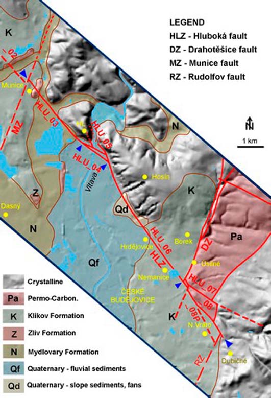
Fig. 1: Sketch of the course of the Hluboká fault between Munice and Dubičné. Adopted from PRACHAŘ (2012).
Towards the northwest, the propagation of the Hluboká fault is described far beyond the western boundary of the Budějovice Basin. However, the course of the Hluboká fault labeled as the “Hluboká fault sensu stricto” can be clearly demonstrated in the section between Munice and Dubičné (Fsections HLU_03 to HLU_06 and HLU_08. Here, the Hluboká fault represents the north-eastern tectonic margin of the Budějovice Basin (See Fig. 1). The total length of the defined fault section is approximately 12 km (see ŠPAČEK ET AL., 2010). See Raster geological maps, Czech Geological Survey, sheets 32-22 České Budějovice, 22-44 Hluboká and 22-43 Vodňany.
In the southeast, after crossing with the Drahotěšice fault near Úsilné, the Hluboká fault splits in three fault branches of a horsetail fault structure (sections HLU_07, HLU_08 and HLU_08P).
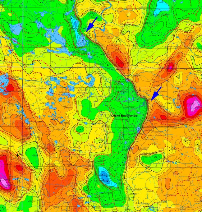
At the other end, a distinct segmentation of the Hluboká fault can be observed near Munice, where it is interrupted by the Munice fault of the NNE-SSW direction. The continuation of the Hluboká fault to the northwest is already taking place inside the Budějovická Basin, without any apparent morphological manifestation (see Fsection HLU_02). Outside the basin, the trace of the Hluboká fault can be traced between Dubenec and Strpí, where the Hluboká fault is interrupted by the Blanice valley fault of the N-S direction. The trace of the fault follows a shallow valley of the Radomilice brook with several ponds. The course of the fault is indicated by significant gravity and morphological manifestations in the section Munice - Dubičné. The significant linear maximum of the horizontal gradient of Bouguer's anomalies (see Fig. 2) can be observed over almost the entire fault segment between Hluboká nad Vltavou and Dubičné. This maximum of the gradient is explained by ŠPAČEK ET AL. (2010) as a steep limitation of the deepest part of the Budějovice Basin with thickness of Cretaceous sediments about 300 - 350 m.
Fig. 2: A section from the map of the residual gravity field depicting the eastern part of the Budejovice Basin. Step of isolines 0.25 mGal. The map is completed with the course of Linsser's indications of density contacts at a depth of 250 m. Adopted from ŠPAČEK ET AL., 2010.
Fault structure and dip
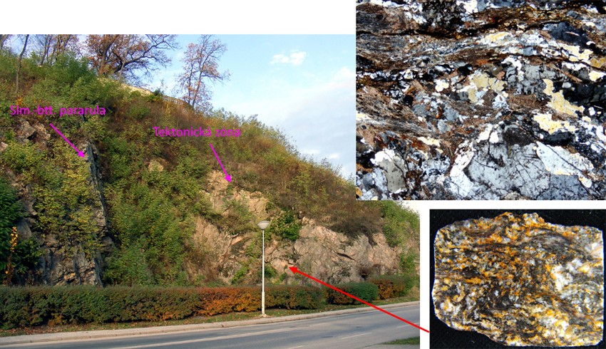
The angle of dip of the fault plane is assumed to be steep, about 70° to the SW. Observations of fault core in sounds rocks reached by drills are not available. Near the surface, the fault rocks (all crystalline rocks) are completely weathered and argilized. However, it was possible to investigate the outcrop of one of the related dislocations in Hluboká-Podskalí (see Fig. 3). The fault core in outcrop HLU_A had the character of approximately 60 m thick shear zone in the sillimanite-biotite paragneiss. The rock was probably also affected by younger biotitization. The dislocation acted as a left-slip fault with the azimuth 329° and dip 64° to the southwest. Part of the fault core was a zone about 10 m thick, consisting of folded fine-grained gneisses with erlan lentil.
Fig. 3: View of the outcrop HLU_A in Hluboká-Podskalí with mylonized and folded sillimanite-biotite paragneiss (see details on the right). Adopted from PRACHAŘ (2012).
Cross structures and Segmentation
Geological maps (see e.g. Raster geological map 1 : 50 000, Czech Geological Survey – sheets 22-44 Hluboká and 32-22 České Budějovice) show two important cross structures that segmented the Hluboká fault. These are the NNE-SSW faults, Drahotěšice and Munice Fault. Further segmentation is expected near Strpí, where the Hluboká fault is interrupted by the Blanice valley fault, also of the N-S direction in general. Clear segmentation is also at Hluboká nad Vltavou, where the Vltava river leaves the Budějovice Basin and breaks through the slope of the Hluboká fault. According to geological maps of the Czech Geological Survey, the course of the NNE-SSW fault is also assumed at this locality. The presence of such a fault was not excluded by the investigation (see ŠPAČEK ET AL., 2010). However, the Hlubocá fault segmentation at this point seems much more complicated than a simple horizontal shift in the N-S direction. Various discontinuities in the broader shear zone seem to have been applied as the azimuth of the fault also slightly changes at this location. A ness with the Hluboká chateau rises between the branches of the fault and it is possible to observe the mylonitized and folded rocks of this shear zone on the outcrops below the chateau (see Fig. 3).
Scarp morphology
The morphological manifestation of the Hluboká fault is evident at first sight, especially between Hluboká and Hrdějovice (see Fig. 4), where the slope parallel to the fault plane has a height of up to 65 m and angle of slope about 15‐30°, sometimes 45°.
Fig. 4: Panoramic view of the straight running slope between Hluboká and Hrdějovice (on the left the church tower in Hosín, on the right the village Hrdějovice), where the Hluboká fault runs near the foot of the slope. In the foreground of the picture is a wide floodplain of the Vltava with terrace sediments of Riss, Würm and Holocene age. View from southwest. Photo I. Prachař, 2010.
In the segment between Munice and Hluboká, the Hluboký fault does not manifest itself in morphology. The apparent morphological slope (see Fig. 5) with angle of slope of 3‐11° in spatial coincidence with this segment of the Hluboká fault represents mainly the edge of the Miocene accommodation space.
Fig. 5: Morphology of the area of the Hluboká fault segment between Munice and Hluboká. View from the southwest to Hluboká nad Vltavou over Podhradský pond. The trace of the Hluboká fault is assumed at the south-western outskirts of the city. Photo I. Prachař, 2010.
Seismicity
No earthquake epicenters were recorded in the fault zone. Except for one micro-earthquake near Strpí (49.135°N, 14.241°E) on May 5, 2003, which had ML = 0.3.
Pre-Miocene evolution
The tectonic history of the Hluboká fault must be assessed in the context of the development of the whole South Bohemian region, and in particular the Permo-Carboniferous and Cretaceous basin structures. The tectonic development of the South Bohemian region was influenced by two significant fault systems of the direction of NNE-SSW (direction of the Blanice furrow) and NW-SE (direction of the so called “Jáchymov” system of faults). Both fault systems were established at the latest in the last stages of the Moldanubian metamorphosis and significantly influenced the formation and development of the platform cover of this area (see PRACHAŘ, 2012).
Significant tectonic movements on these fault systems took place in the Asturian tectogenetic phase (Stephanian C). As a result, the accomodation space of the Permo-Carboniferous basins was opened in the fault zone of the Blanice Furrow. After a long phase of denudation and peneplenization of the Variscan mountains, a significant revival of tectonic movements occurred only during the Mediterranean tectogenetic phase in the Turonian Era (≈ 93-89 Ma).
In the accommodation space, stretched in the NW-SE direction, between Vodňany and České Velenice with continuation to the Austrian Waldviertel, two centers were formed - the Budějovice Basin and the southern part of the Třeboň Basin, which was drained to the SE. The faults of the NW - SE direction, the Hluboká fault in the Budějovice Basin and the faults of the Stropnice Zone in the Třeboň Basin contributed decisively. However, a comparison of the individual sedimentation cycles in different parts of the basins shows that the syngenetic down thrust movements were identical in both basins and therefore both basins underwent the same tectonic development as it considers SLÁNSKÁ (1963).
As a result of the Ilesian phase in the Alpine area, at the turn of the lower and middle Santonian (≈ 85 Ma), there was a slight uplift of the South Bohemian region, interruption of sedimentation of the lower part of the Klikov Formation and a new arrangement of the depositional area, including mainly the Třeboň Basin, where the upper part of the Klikov Formation began to be deposited. Further uplift of the southern part of the Bohemian Massif during the Wernigerode phase of the Alpine orogeny at the end of the Santonian (≈ 83 Ma) led to the ending of the Senonian sedimentation in the South Bohemian basins. The mild, uneven uplift of the Bohemian Massif, associated with kaolinic weathering of crystalline rocks, denudation and peneplenization, probably continued until the end of the Eocene. Apparently, due to the Pyrenees phase, a partial height differentiation of the surface and local sedimentation of the Lipnice Formation (early Oligocene) occurred (see Fig. 6).
Fault activity in late Cenozoic
Tertiary
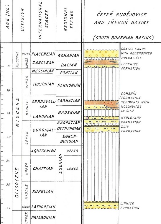
Several sedimentation cycles took place during Miocene and Pliocene. First during Ottnangian (≈ 18.3 - 17.0 Ma), when less important sediments of the Zliv Formation were deposited in an area little overlapping the Senonian Basins. At the Karpatian (≈ 16.5 Ma), the wider area was subsidized, and the depositional area expanded far beyond the Senonian Basins. In the depressions, the flow lakes formed NW-SE and NNE-SSW, which were drained to the south. Fluvial-lacustrine sedimentation began in the Karpatian by deposition of the lower part of the Mydlovary Formation (in the Budějovice Basin in the Pištín “Ditch” and in the Třeboň Basin in the “Ditches” of the Soběslav, Šalmanovice and Stropnice) and gradually expanded to the wider periphery of the Senonian Basins. The lithological development of the sediments of the Mydlovary Formation was influenced mainly by the oscillation of the depositional area level in relation to the level of the nearby sea. Due to the getting of brackish and sea water into the depositional area during the Badenian (≈ 16.1 Ma), there was a change in the lithology of sediments and deposition of diatomite clays (see ŘEHÁKOVÁ, 1959) of the upper part of the Mydlovary Formation. At the end of the Badenian, the last Miocene sedimentation cycle took place, during which the diatomite clays of the Domanín Formation were deposited in the Třeboň Basin and the Vrábeč and Koroseky gravelly sands with moldavites (see ŽEBERA, 1967) were deposited in the Budějovice Basin and on its periphery.
The next cycle took place only in Pliocene, when fluvial-lacustrine sediments of Ledenice Formation were deposited. Other short cycles also appeared in Romanian (Kamenný Újezd gravelly sands) and at the turn of Late Pliocene and Pleistocene (Zbudov gravelly sands).
According to some authors (e.g. A. Malecha – see Malecha, 1994) Miocene and Pliocene sedimentation cycles were accompanied by fault displacements, assuming activity faults of the NW-SE, NNE-SSW and E-W direction. A. Malecha created the concept of Miocene tectonic “ditches”, i.e. elongated basins limited by faults. Later surveys, however, did not confirm the Malecha’s concept of tectonic ditches, as e.g. nearby Pořežany ditch or Pištín ditch inside the Budějovice Basin (see PRACHAŘ, 2012).
Fig. 6: Stratigraphic table of Tertiary in the South Bohemian basins. KLOMÍNSKÝ ED. (1994).
Numerous indications and evidence (see ŠPAČEK ET AL., 2010; PRACHAŘ, 2012) suggest that the Hluboká fault is extinct and its morphological manifestation is primarily the result of differential erosion at the contact of very weakly consolidated sediments of the Budějovice Basin and resistant crystalline rocks around. In the middle part of the fault (Hluboká-Hrdějovice), the intensity of erosion was significantly increased by the rapid deeping of the Vltava river.
There are indications that the Hluboká fault does not disrupt the sediments of the Mydlovary Formation, which overlap the trace of the fault between Munice and Hluboká nad Vltavou. The assumption of the transgressive character of the deposit of the Mydlovary Formation was confirmed and its disruption was not observed even in the available outcrops. Investigations also showed that the course of layers of Zliv sediments is also not disturbed by the movement at the Hluboká fault, and no significant discrepancies were found when the relict base heights around the fault were compared.
Quaternary
In the section between Hluboká and Hrdějovice, height continuity of the levels corresponding to the Holocene and the Late Würm was indicated in blocks separated by a fault. A similar thickness of Quaternary river sediments was observed on both sides of the fault, too. Dating clearly confirmed that there was no displacement on the Hluboká fault over the last 22,000 years (see Špaček et al., 2010). But the position of other terrace levels indicates the integrity of their course at least since Mindel (about 800,000 years).
Related local evidence
(See layer Local evidence on a map. The sites are listed in northwest-to-southeast order.)
Munice: Trench Munice and Seismic profile P-MU
evi_ID: MUN_A
fsec_IDs: HLU_03
editor: Ivan Prachař
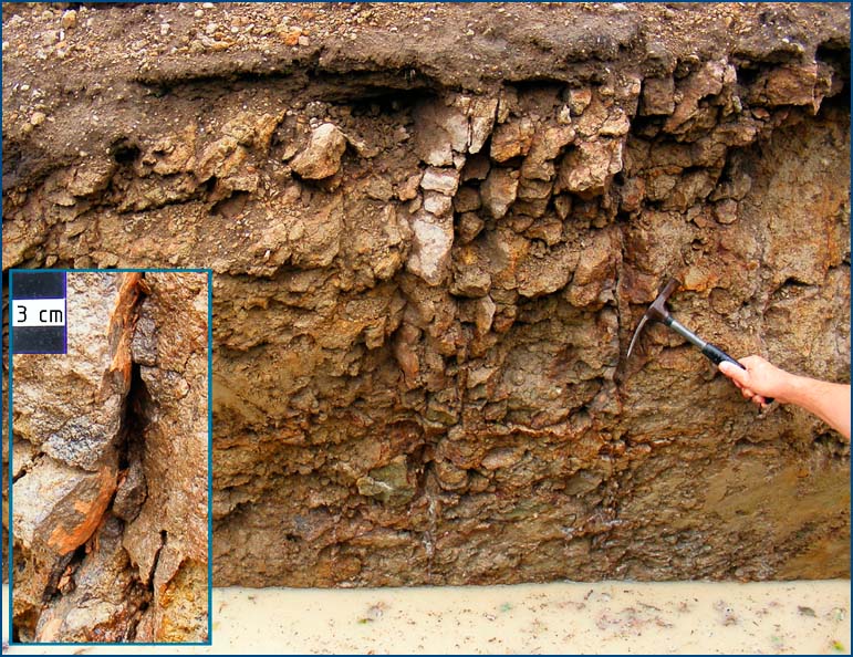
Hluboká fault has no morphological manifestation between Hluboká and Munice, but it could be assumed that its trace is covered by sediments of the Zliv Formation (Ottnangian, ca 18.3 - 17.0 MA). The fault trace was uncovered at the point that was selected by means of ERT profiles and core drilling by the trench Munice with length 100 m. A more precise delimitation of the faults was made more difficult by the fact that at this point the Hluboká fault does not form the boundary between the sediments of the Budějovice Basin and the crystalline complex. The fault plane was not reached because the Zliv sediments had a thickness of about 6 m. However, the sediments of the Zliv Formation were not interrupted by the Hluboká fault. There was no interruption in the course of the layers throughout the length of the trench, too (see Fig. 7). Also, the evaluation of the drilling profile of the drills MUN-5, MUN-4, MUN-3, MUN-6, MUN-7 and MUN-2 did not show any significant disturbance of the course of the Zliv sediment base.
Fig. 7: View of the trench wall (shallow southern part of the trench) with a pair of continuous cracks in the position of silicified Zliv sandstone. The opening of the cracks and the decay of the bed into fragments of decimeter dimensions are the result of the Quaternary weathering processes. In the cut-out on the left is a detailed view of the crack. The cracks in the Zliv sediments were interpreted as the result of probably tertiary failure of rigid beds of silicified sandstones lying on a plastic, clay base (see ŠPAČEK ET AL., 2010). Adopted from PRACHAŘ (2012).
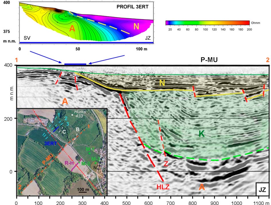
The deeper fabric of the Budějovice Basin near Munice (between Munice and Hluboká nad Vltavou) was very clear from the seismic reflection profile P-MU. Here the border between Cretaceous sediments and the crystalline complex (fault plane) is covered by a thick layer of sediments of the Mydlovary Formation. As can be seen from the migrated seismic reflection profile (see Fig. 8), the sediments of the Mydlovary Formation are deposited sub-horizontally and their base is located at a depth of approximately 50-70 m below the surface. The horizontal reflectivity of this layer shows a quiet sedimentation of the Mydlovary Formation without tectonic failure. Only at the base there are discontinuous reflections that may show both the uneven relief of the surface of the Klikov Formation (Senonian) and the fault activity within the masses that sedimented at the beginning of the deposition of the basal layers of the Mydlovary Formation. In the north-eastern part of the profile, only the lower part of the multiple representing main reflection of the base of the Mydlovary Formation can be observed here. The course of the inflow into the Miocene depositional area, which flowed along the eastern slope of the Hůrka elevation, is assumed by PRACHAŘ (2012). Transgression of Mydlovary sediments over crystalline complex is also well evident on the 3ERT profile (see Fig. 8 – upper part).
Results of geophysical survey of the edge of the Budějovice Basin between Munice and Hluboka n.Vlt. The upper part of the figure shows an isoohmic section of the 3ERT profile, taken from ŠPAČEK ET AL. (2010). The interpretation of the reflex seismic profile of P-MU is shown in the lower part (see DECKER ET AL., 2011). The lithological units are marked with the letters - N - Miocene sediments of the Mydlovary Formation, K - Senonian deposits of the Klikov Formation, A - crystalline rocks. The map in the lower left corner of the figure shows all the exploratory work carried out at this location: geophysical profiles measured by the electromagnetic dipole profiling (DEMP) method and the combined profiling (KP) method - light blue dashed lines 1,2 and 3 (see ŠPAČEK ET AL., 2010). Depicted 3ERT profile is blue. ERT profiles B and C performed in 1993 (see ŠIMŮNEK ET AL., 1995) are white. Seismic reflection profile of P-MU with a length of 1150 m is marked as orange dashed line (see DECKER ET AL., 2011). The thick dark purple line, designated R-H, represents the shallow trench of the wastewater conduit described by ŠPAČEK ET AL. (2010). The core drills M-1, M-2 (ŠIMŮNEK ET AL., 1995) and M-3 (ŠPAČEK ET AL., 2010) are marked in green. The assumed course of the Hluboká fault line (HLZ), covered by Miocene sediments, is marked by a red, double dashed line. Adopted from PRACHAŘ (2012).
The seismic profile was interpreted in such a way that the Hluboká fault does not disrupt the sediments of the Mydlovary Formation. This interpretation can be supported by the documentation of the shallow trench for wastewater conduit (R-H in Fig. 8). No failure of the Tertiary sequence of clay sediments was detected in its profile.
Hluboká and Vltavou: Outcrop in paragneiss
evi_ID: HLU_A
fsec_IDs: HLU_01P (parallel)
editor: Ivan Prachař
See the text of the chapter “Fault structure and dip” and Figure 3 above.
Hluboká and Vltavou: The NNE-SSW fault that segmented the Hluboká fault in the tectonic junction in Hluboká nad Vltavou
evi_ID: HLU_B
fsec_IDs: HLU_01T (transverse)
editor: Ivan Prachař
The delimitation of this fault is based mainly on the documentation of the outcrop under the Hluboká castle (see outcrop C in the Fig. 9), where continuous cracks with horizontal striations were observed. There are more significant discontinuities in the directions N‐S, NW ‐ SE and NE ‐ SW. The occurrence of thin zones (about 5 - 10 mm thick) with silicification and tourmalinization was found on the planes of discontinuities.
The presence of dislocation of the N-S direction is also evidenced by findings from drills HL-11 (see ŠPAČEK ET AL., 2010) and J2 (PUPÍK, 2007), in which a highly weathered, altered (chloritized) paragneiss was drilled.
Hluboká and Vltavou: Wear - the tectonic junction in Hluboká nad Vltavou
evi_ID: HLU_C
fsec_IDs: HLU_01P (parallel), HLU_01T (transverse), HLU_04, HLU_04P, HLU_05, HLU_06
editor: Petr Špaček, Ivan Prachař
Interpretation of the tectonic junction in Hluboká is shown in the Fig. 9.

Fig. 9: Results of geophysical survey of the edge of the Budějovice Basin between Munice and Hluboka n.Vlt. The upper part of the figure shows an isoohmic section of the 3ERT profile, taken from ŠPAČEK ET AL. (2010). The interpretation of the reflex seismic profile of P-MU is shown in the lower part (see DECKER ET AL., 2011). The lithological units are marked with the letters - N - Miocene sediments of the Mydlovary Formation, K - Senonian deposits of the Klikov Formation, A - crystalline rocks. The map in the lower left corner of the figure shows all the exploratory work carried out at this location: geophysical profiles measured by the electromagnetic dipole profiling (DEMP) method and the combined profiling (KP) method - light blue dashed lines 1,2 and 3 (see ŠPAČEK ET AL., 2010). Depicted 3ERT profile is blue. ERT profiles B and C performed in 1993 (see ŠIMŮNEK ET AL., 1995) are white. Seismic reflection profile of P-MU with a length of 1150 m is marked as orange dashed line (see DECKER ET AL., 2011). The thick dark purple line, designated R-H, represents the shallow trench of the wastewater conduit described by ŠPAČEK ET AL. (2010). The core drills M-1, M-2 (ŠIMŮNEK ET AL., 1995) and M-3 (ŠPAČEK ET AL., 2010) are marked in green. The assumed course of the Hluboká fault line (HLZ), covered by Miocene sediments, is marked by a red, double dashed line. Adopted from PRACHAŘ (2012).
Opatovice: The trace of the Hluboká fault covered by the terrace sediments of the Vltava river
evi_ID: OPA_A
fsec_IDs: HLU_06
editor: Ivan Prachař
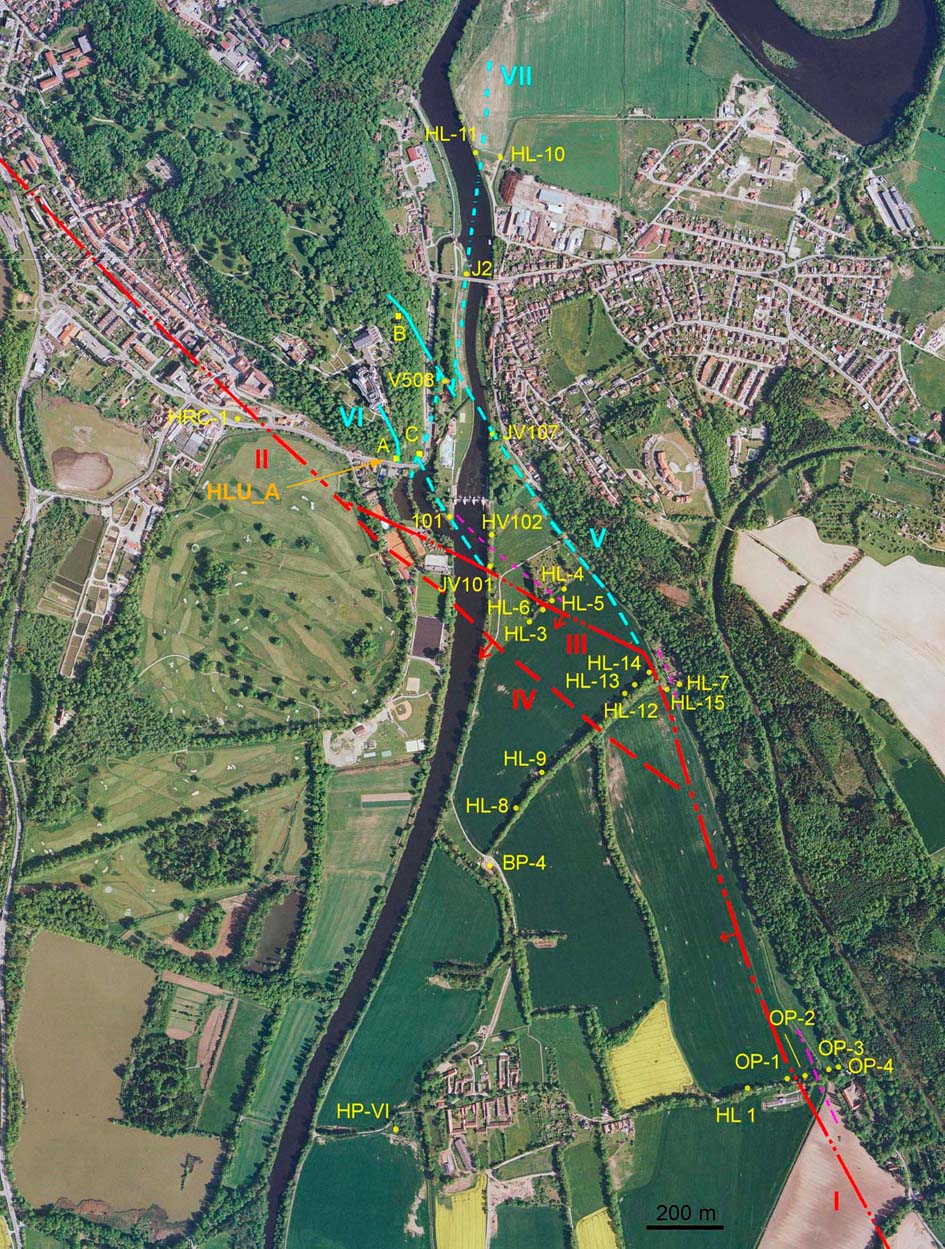
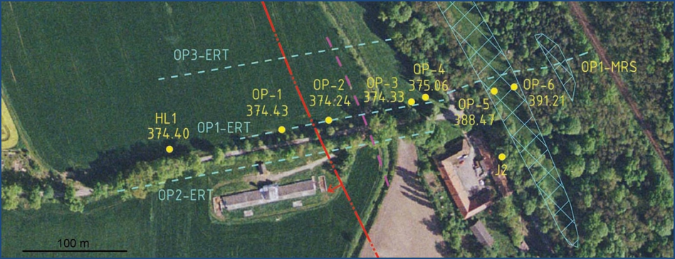
The “Opatovice profile” characterizes the edge of the Budějovice Basin west of Opatovice village, at a point where the edge of the basin is identified with the foot of a distinct, steep straight running slope (see Fig. 4) protruding emerging from the flat relief of the basin (see Fig. 10) and wherein the contact between the block of Cretaceous sediment and the crystalline massif is tectonic, with a fault throw at least 300 m (see drill HL1 log; GF P018881; Dornič et al., 1966).
Fig. 10: Situation on the “Opatovice profile”. Light blue dotted lines - geophysical profiles with the name and the method used. Core boreholes are marked in yellow (name and altitude). Light blue hatch - platforms with clastic sediments. Red dash-and-dot line - supposed line of Hluboká fault covered by Pleistocene sediments of the Vltava River. Purple dashed line - supposed boundary between kaolinized crystalline rock and sound rock. Adopted from ŠPAČEK ET AL., 2010.
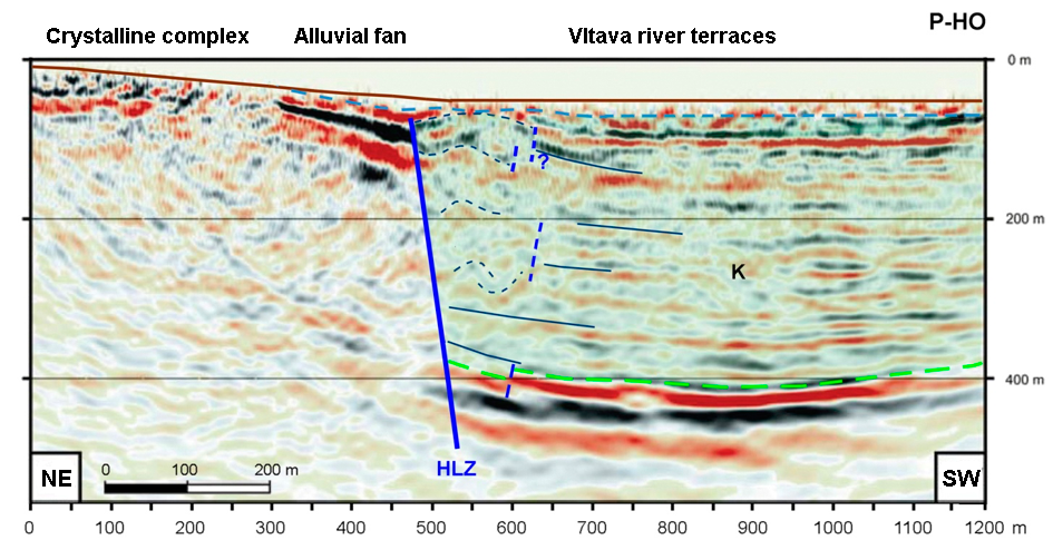
The result of seismic reflection profiling (profile P-HO (Hosín) about 400 m south of the “Opatovice” profile; DECKER AT AL., 2010-2011; see Fig. 11) supports the interpretation of one fault plane forming the boundary between the crystalline complex and the Senonian sediments between Hluboká-Zámostí and Hrdějovice.
Fig. 11: Interpretation of the seismic reflection profile P-HO (see DECKER ET AL., 2010-2011). In the central part of the picture, the assumed Hluboká fault plane (HLZ) is marked on the profile. The letter “K” and green shading indicate the Senonian sediments of the Klikov Formation, the crystalline rocks are without marking and shading. Adopted from Prachař (2012).
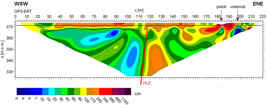
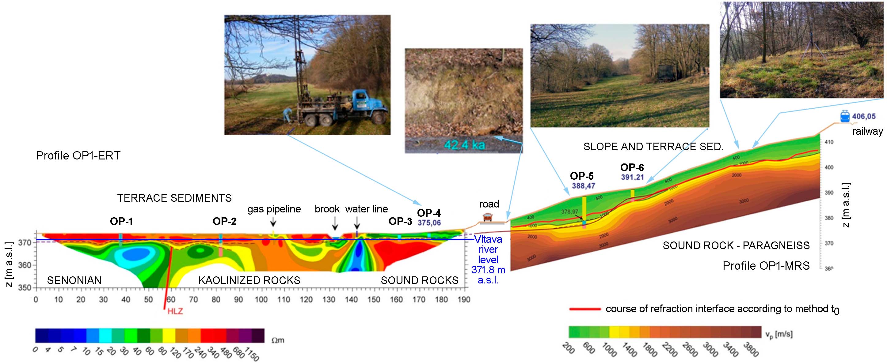
The position of the Hluboká fault plane on the “Opatovice” profile is evident from the ERT profiles OP1-ERT and OP3-ERT (see Fig. 12 and Fig. 13).
Fig. 12: ERT cross section OP3-ERT with interpretation of the Hluboká fault plane (red line – HLZ). Adopted from ŠPAČEK ET AL., 2010.
Fig. 13: Interpretation of the profile OP-1 based on ERT profiling (left) and seismic refraction profiling (right) with interpreted Hluboká fault plane (red – HLZ) and Quaternary sediments: terrace sediments of the Vltava river (Würm and VI – Riss levels) in the basin plain, OSL dated colluvium in the road cut with age 42.4 ka and slope and terrace sediments deposited on a stair slope on the edge of the Budějovice Basin (probably Vb-Riss level in the drill OP-5). The photos show various morphological elements on the profile. Based on the data in ŠPAČEK ET AL., 2010.
The findings from the “Opatovice” profile clearly show that the Hluboká fault does not run at the foot of the slope, but about 100 m inside the basin. The significant morphological slope is therefore not a fault plane but it is the result of lateral erosion of the Vltava river during the Pleistocene.
Hrdějovice: The trace of the Hluboká fault covered by the alluvial fan
evi_ID: HRD_A
fsec_IDs: HLU_06
editor: Ivan Prachař
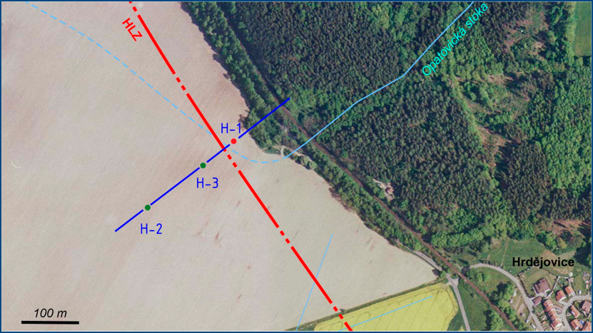
The “Hrdějovice” profile represents the trace of the Hluboká fault covered by the alluvial fan. As well as on the “Opatovice” profil, also on the “Hrdějovice” profile the edge of the basin is identified with the foot of a distinct, steep straight running slope (see Fig. 4). But unlike the previous site at the foot of the slope, there is a large alluvial fan covering the fault trace.
The interpretation of the profile was performed based on evaluation of three core drills H ‐ 1, H ‐ 2, H ‐ 3 (see Fig. 14). All drills have undergone, in various thickness, both the proluvial sediments of the fan and the terrace sediments of the Vltava river and reached the pre-Quaternary basement. The drill H ‐ 1, situated 55 m south of the road Hluboká nad Vltavou - Hrdějovice, reached a crystalline rock at a depth of 18.7 m. Drills H ‐ 3 and H ‐ 2, situated to the southwest, then reached the claystone of the Klikov Formation.
Drill logs show interfingering of terrace and proluvial sediments. Terrace sediments on the base of the fan sequence probably belong to sediments VI - Riss level. In the roof of this layer there are proluvial clastics and colluviums, as shown by drilling logs (see Fig. 15). Their age, determined by the OSL method on feldspar, is 53.6 thousand years.
Fig. 14: Profile “Hrdějovice” - see blue line. The color of the dots, which represent boreholes H-1, H-2 and H-3, also indicate the type of pre-Quaternary basement (red - crystalline; green - Senonian sediments). The supposed HLZ line, covered by Pleistocene fluvial and slope sediments, is marked by a red dash-and-dot line. Adopted from PRACHAŘ (2012).
Fig. 15: Profile “Hrdějovice”. 1 - crystalline; 2 - Cretaceous (Senonian); 3 - fluvial sediments of the Vltava river; 4 – cobble colluvium; 5 - sandy to silty colluvium (proluvium); 6 - silty (loamy) colluvium; 7 - railway track embankment; the expected course of the Hluboká fault is shown in red; drill label: name and altitude in m a.s.l. Adopted from ŠPAČEK ET AL. (2010).
The findings from the “Hrdějovice” profile again clearly show that the Hluboká fault does not run at the foot of the slope, but about 80-120 m inside the basin. The significant morphological slope is therefore not a fault plane but it is the result of lateral erosion of the Vltava river during the Pleistocene. The alluvial fan is a result of the creek activity. After moving the meandering river from the foot area of the slope, probably during Würm, a huge alluvial fan was formed in the mouth of the Opatovická stoka stream in the basin.
Main data sources for fault map
Raster geological maps 1 : 50 000, Czech Geological Survey, sheets 32-22 České Budějovice, 22-44 Hluboká and 22-43 Vodňany.
ŠPAČEK, P., PRACHAŘ, I., VALENTA, J., ŠTĚPANČÍKOVÁ, P., ŠVANCARA, J., PISKAČ, J., PAZDÍRKOVÁ, J., HANŽLOVÁ, R., HAVÍŘ, J., MÁLEK, J., 2010. Paleoseismologické vyhodnocení průzkumu zlomových struktur v okolí JE Temelín. Závěrečná zpráva o řešení veřejné zakázky ve výzkumu a vývoji. MS, Ústav fyziky Země MU Brno, Energoprůzkum Praha spol. s r.o., Ústav struktury a mechaniky hornin AV ČR, v.v.i. Praha. 2010. [in Czech]
Other notes
…
References
- DECKER, K., HINTERSBERGER, E., HOMOLOVA, D., 2010-2011. Paleoseismology of Temelin´s Near-Regional Faults. Manuscript, AIP (Austrian Interfacing Project), Interim Report 1, 2, 3, Universität Wien.
- DORNIČ, J., GABRIELOVÁ. N., KNOBLOCH, E., MALECHA, A., ŘEHÁKOVÁ, Z., ŘEZÁČ, B., SLÁNSKÁ, J., VOJTĚCH, S., 1966. Vysvětlivky k základní geologické mapě 1:50 000, list M-33-101-D (Hluboká n.Vltavou). Ústřední ústav geologický, Praha. [in Czech]
- KLOMÍNSKÝ, J. EDITOR, 1994. Geologický atlas České republiky, Stratigrafie = Geological atlas of the Czech Republic, Stratigraphy. Český geologický ústav, 1994.
- MALECHA, A., 1994. Geologická a tektonická stavba jihovýchodní části budějovické pánve a její vývoj. Unpublished manuscript. Dolní Bukovsko, 1994, 27 p. [in Czech]
- PRACHAŘ, I., 2012. Lokalita JE Temelín. Komplexní charakteristika lokality z hlediska splnění geologických a seismologických požadavků na lokalitu jaderného zařízení. Unpublished manuscript
 , RNDr. Ivan Prachař, CSc. Praha. 2012. [in Czech]
 - PUPÍK, V., 2007. Hluboká nad Vltavou - mosty 146-001 a 146-002, podrobný geotechnický průzkum. Stavební geologie-Geotechnika, a.s., Praha. Geofond Archive sign. GF P116281.
- ŘEHÁKOVÁ, Z., 1959. Mikrofytopaleontologický výzkum diatomitu na území ČSR – výroční zpráva za r. 1958 – lokalita Čtyři dvory u Českých Budějovic. ÚÚG, Praha, GF P010238. [in Czech]
- SLÁNSKÁ, J., 1963. Výsledky petrografického výzkumu klikovského a mydlovarského souvrství. Věstník ÚÚG, roč. XXXVIII, 1963, 367-384. [in Czech]
- ŠIMŮNEK P., PRACHAŘ I., BARTÁK V., DOMÁCÍ L., PISKAČ J., 1995. NPP Temelín Construction Site. Supplementary geological and seismological surveys. Part A: Tectonics. Part B: Seismic Risk. Unpublished manuscript
 , Energoprůzkum Praha. [in Czech]
 - ŠPAČEK, P., PRACHAŘ, I., VALENTA, J., ŠTĚPANČÍKOVÁ, P., ŠVANCARA, J., PISKAČ, J., PAZDÍRKOVÁ, J., HANŽLOVÁ, R., HAVÍŘ, J., MÁLEK, J., 2010. Paleoseismologické vyhodnocení průzkumu zlomových struktur v okolí JE Temelín. Závěrečná zpráva o řešení veřejné zakázky ve výzkumu a vývoji. MS, Ústav fyziky Země MU Brno, Energoprůzkum Praha spol. s r.o., Ústav struktury a mechaniky hornin AV ČR, v.v.i. Praha. 2010. [in Czech]
- VRÁNA, S., SUK, M., MALECHA, A., KOPECKÝ, A., 1994. Tektonická stavba jihočeské oblasti a její vývoj. Unpublished manuscript, chapter 6, pp. 22-90. [in Czech]
- ŽEBERA, K., 1967. Moldavite-bearning sediments between Koroseky and Holkov in South Bohemia. Věst. ÚÚG, 42, 5, 327-337, Praha. [in Czech]
